 VAST Challenge'19 MC2:Citizen Science to the Rescue
Task 2: Represent uncertainty in the measurement of radiation across the city
a) Compare uncertainty of the static sensors to the mobile sensors. What anomalies can you see? Are there sensors that are too uncertain to trust?
| Sensor Type |
Uncertainties |
Evidence (if applicable) |
| Static Sensors |
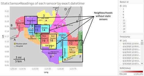
There are very few static sensors located in St.Himark. There are only 9 static sensors when there are 19 neighbourhoods that need to be studied by the emergency team. Thus, the radiation data collected do not give sufficient information for analysis for neighbourhoods without static sensors such as Easton, Northwest or Scenic Vista. |
 |
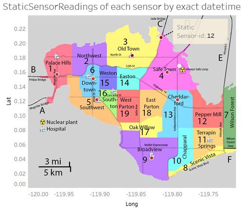
| Not all the static sensors are located at the heart of the neighbourhood. For example, sensor with sensor id 12 is located in between Old Town and Safe Town, which does not help in interpreting the data correctly as the analyst would not know which neighbourhood to focus on when studying the radiation fluctuations of the neighbourhoods. |
 |
| The radiation level recorded by static sensors are used to interpolate the radiation level of the whole neighbourhood, which might not be accurate and cause uncertainties in the radiation level of each neighbourhood. Only the circular area of the neighbourhood nearer to the location where the sensor is placed has higher confidence level of the radiation level recorded by the sensor. |
| Mobile Sensors |
As these citizen-operated sensors are mobile, the radiation level recorded by the mobile sensors do not tell us the specific changes in the radiation level of each neighbourhood. We only know the changes in the radiation level of the route that the citizen-scientists took. |
| Each radiation level recorded by mobile sensors might not be entirely independent of each other because as citizen-scientists travel from one place to another with their own mobile sensors, there is a possibility of their already-contaminated cars further contaminating the areas that these citizens go to, thus increasing the radiation level when recording the data. |


