ANLY482 AY2017-18T2 Group 11 Project Overview
| HOME | PROJECT OVERVIEW | ANALYSIS & INSIGHTS | PROJECT MANAGEMENT | DOCUMENTATION | ANLY482 MAIN |
| Final | Initial |
|---|
| Motivation |
The lack of use of a VRS to provide delivery routing solutions is one that resonates strongly with some SME companies operating within the logistics sector. A possible reason is due to the high cost associated with the purchase of such a software. To illustrate, Paragon – a VRS provider in the United Kingdom, revealed that a system designed for a Delivery Service Company with a fleet size of 100 vehicles can expect license fees of up to £50,000. To exacerbate this situation, the listed price has yet to include additional cost such as the training cost and the maintenance fee that is usually required with the use of the software. This example serves to exemplify the high cost associated with a VRS and it can be observed that this is not in line with the purchasing capabilities of a typical SME. Thus, the team believes that it is even more crucial to identify and create low-cost solutions so as to ensure SMEs, too, have vehicle routing tools at their fingertips.
In addition, another underlying motivation for this research is due to the lack of relevant skillset in the current job market. To be more specific, in order to derive a VRS, it is imperative of the developer to possess domain expertise in the geospatial and computer science field. However, the lack of low-cost solutions in the market seems to indicate a possibility that such skills are scarce. Besides, given the team dynamics, it seems that the team is well-poised to derive a VRS for the SMEs.
| Project Objective & Goal |
Like all business models, operating with such a business model is not without its flaws. This form of business model has resulted in the company being susceptible to the integrity and capabilities of external parties – Temporary Drivers. As such, even if the company were to know the number of parcels to deliver in the following day, it might still be unable to accurately determine the number of Temporary Drivers needed. While the company has pre-existing solutions in solving this issue, they are still interested in exploring alternatives that will help improve their capabilities in this aspect.
In response, the team suggests that the company can engage in a systematic method to guide its decision on deciding the number of Temporary Drivers to employ. This could be accomplished by utilising a “Logistics Application” – Vehicle Routing Software (VRS), which is able to provide delivery routing details such as the time and route taken when a predetermined number of drivers is hired to complete the days’ worth of delivery. Ultimately, when the company is armed with these details, the company would not be at the mercy of its external contractors.
| System Architecture Design |
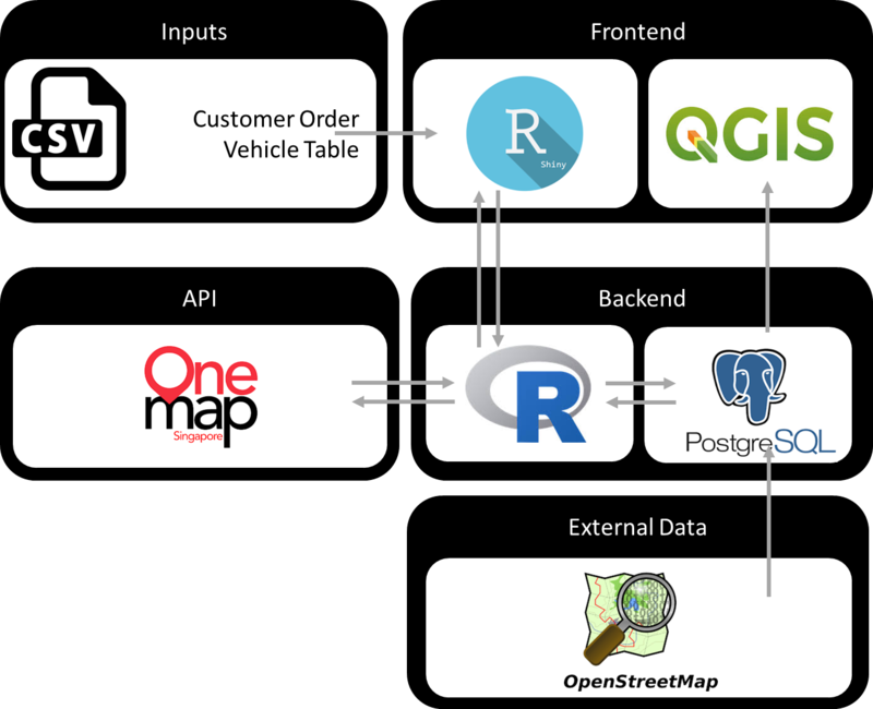
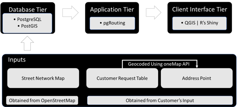
This system architecture contains the interaction between various software and libraries used in deriving the model. The specific details pertaining to each of these components will be explored in the next section.
| Methodology - Framework |
1. Inputs
OpenStreetMap - This is a collaborative project dedicated to creating free and editable map of the world. The main motivation underlying this project is to solve the issue of unavailability of map information across the world. OpenStreetMap attempts to do so by tapping on the advent of inexpensive portable satellite navigation devices. The open-sourced map data is collected from scratch by volunteers worldwide who utilised tools such as a handheld GPS unit, voice recorder or notebook. In addition to Pedestrian Mapping, it has also expanded its functionality to include Road and Cycling Networks which has proved to be useful to many. This data can be viewed on multiple softwares such as OsmAnd and Maps.me. Moreover, these data can be downloaded into user’s workspace and can be accessed offline. This allows flexibility in less financially capable SME who has no constant access to internet and hence, a strong reason for the adoption of this mapping tool. More critically, OpenStreetMap uses actual vector data which provides routing capabilities. As a result of the underlying vectors in OpenStreetMap, it will be extremely pertinent in building a routing application.
oneMap - This is an integrated online geospatial platform that provides location-based information. It’s open-sourced API has many functions, amongst which are its ability to allow users to geocode locations based on postal code. Besides being open-sourced, this API is developed by the Singapore Land Authority which adds credibility to its capabilities.
2. Database Tier
PostgreSQL - Also known as Postgres, this is an object-relational, enterprise database management system, whose primary functions are to stores data securely and returns the data in response to requests from other software programs. This open-sourced software is jointly developed by individuals and diverse group of companies who are also known as the PostgreSQL Global Development Group. Its developers have created it to possess the capabilities of handling workloads ranging from single-machine applications to large web-facing applications with many concurrent users. In addition, its SQL-specification conformance and data integrity features allow only the strictest ways to interact with the database, much to the delight of security fans. Due to these capabilities, many industries adopt this database management such as Telecom, Media and e-Commerce.
PostGIS - This is an open-sourced geospatial extension of PostgreSQL. It follows the simple features for SQL specification from the Open Geospatial Consortium and turns PostgreSQL into a spatial database by adding 3 key features and they are: - 1) Spatial Types, 2) Spatial Indexes, 3) Spatial Functions. As these functions are built on PostgreSQL, a key advantage in using this extension is how it automatically inherits important “enterprise” features from PostgreSQL such as crash recovery, hot backup and replication. As a result of this advantage, there are numerous companies such as Uber who utilise heavily on this extension. PostGIS has a full list of case studies in which users has successfully manged to commercialise the use of PostGIS.
3. Application Tier
pgRouting - This is an extension to PostGIS/ PostgreSQL geospatial database and provide geospatial routing functionality based on cost metrics. Besides the shortest route algorithm by Dijkstra, pgRouting also contain other routing algorithms such as All Pairs Shortest Path – Johnson’s Algorithm and Floyd-Warshall Algorithm. These routing algorithms are jointly created by individuals and corporations and have been utilised extensively such as in the case of emergency management or traffic management.
4. Client Interface Tier
QGIS - This is an open-sourced geographic information system to create, edit, visualize, analyze and publish geospatial information.
R’s Shiny - This is open-sourced package available through R that possess interactive capabilities allowing users to build web apps quickly and efficiently.


