Difference between revisions of "JeromeQuah Ex2 Suitability"
| (2 intermediate revisions by the same user not shown) | |||
| Line 31: | Line 31: | ||
! style="text-align: center; width:20em; height: 1em; border:5px ridge Crimson; font-weight:bold; font-size:25px; font-family:Times New Roman !important;; background-color:Black; color: White;"| RASTER MAP | ! style="text-align: center; width:20em; height: 1em; border:5px ridge Crimson; font-weight:bold; font-size:25px; font-family:Times New Roman !important;; background-color:Black; color: White;"| RASTER MAP | ||
|} | |} | ||
| + | |||
[[File:Ex2 Map4 SuitabilityRasterMap JeromeQuah.jpg|900px|thumb|center|'''Gombak Study Area - Suitability Raster Map''']] | [[File:Ex2 Map4 SuitabilityRasterMap JeromeQuah.jpg|900px|thumb|center|'''Gombak Study Area - Suitability Raster Map''']] | ||
| Line 80: | Line 81: | ||
| style="text-align:justify; width:20em; height: 1em; font-size:17px; font-family: Times New Roman !important; background-color:ghostwhite; color: black;" | At first glance, the selected suitable area seems to be on elevated terrain from '''90 to 120 metres''' with a park being within its '''proximity on the West'''. There is '''a service road to its North''', but the transportation or movement to that road itself would require an assisted vehicular mode of transport or transport infrastructure as the road is near the apex of the elevation of Gombak, in which movement from the site to that road would involve transiting up a slope or hill. However, with the prioritization of the Health Risk Factor, we can clearly see that there are '''no buildings in close proximity''' to this site. The following view zooms further into this selected area and the features in its proximity. | | style="text-align:justify; width:20em; height: 1em; font-size:17px; font-family: Times New Roman !important; background-color:ghostwhite; color: black;" | At first glance, the selected suitable area seems to be on elevated terrain from '''90 to 120 metres''' with a park being within its '''proximity on the West'''. There is '''a service road to its North''', but the transportation or movement to that road itself would require an assisted vehicular mode of transport or transport infrastructure as the road is near the apex of the elevation of Gombak, in which movement from the site to that road would involve transiting up a slope or hill. However, with the prioritization of the Health Risk Factor, we can clearly see that there are '''no buildings in close proximity''' to this site. The following view zooms further into this selected area and the features in its proximity. | ||
|} | |} | ||
| + | |||
<!--About The Land Lot --> | <!--About The Land Lot --> | ||
| Line 87: | Line 89: | ||
[[File:Ex2 Map4 TheLandLot JeromeQuah.jpg|900px|thumb|center|'''Location of the Suitable Land Lot for the Communicable Disease Quarantine Centre''']] | [[File:Ex2 Map4 TheLandLot JeromeQuah.jpg|900px|thumb|center|'''Location of the Suitable Land Lot for the Communicable Disease Quarantine Centre''']] | ||
| + | |||
<!--About The Land Lot Text --> | <!--About The Land Lot Text --> | ||
{| align=center width = 100% | {| align=center width = 100% | ||
| − | | style="text-align:justify; width:20em; height: 1em; font-size:17px; font-family: Times New Roman !important; background-color:ghostwhite; color: black;" | | + | | style="text-align:justify; width:20em; height: 1em; font-size:17px; font-family: Times New Roman !important; background-color:ghostwhite; color: black;" | In addition to the full Vector Suitability Map layer view above, the derived suitable site has the following features: |
| + | * '''Area''': 41,584m<sup>2</sup> | ||
| + | * '''Shape''': Wide | ||
| + | * '''Land Elevation''': 70m - 120m | ||
| + | * '''Accessibility Features''': North Service Road 0.3km North | ||
| + | * '''Nearest Buildings''': Military Infrastructure 0.5km North | ||
| + | * '''Natural Features''': Within Close Proximity of Park to the West<br> | ||
| + | |||
| + | However, if the this selected site were to be finalized as the CDQC in Gombak, there would not only be '''high developmental costs''' because of the land terrain, but also '''further additional costs''' for the possible investing of more transportation infrastructure to increase its accessibility to the service roads and tracks of Gombak. Moreover, with the park on its West being in close proximity to the site, it does not contribute towards natural conservation. Given the '''excessive land area''' for this derived site, we can consider starting the CDQC in a smaller area first and consider its expansion in due time to come. The following shows the suggested area within this site. | ||
| − | + | [[File:AreaConsideration JeromeQuah.jpg|450px|thumb|center|'''Suggested Smaller Area for CDQC''']] | |
| − | + | This area was derived with the '''Measure Area Tool''', in which this newly suggested smaller site for the CDQC still qualifies in terms of the '''minimum area requirement'''. Also, it has lower land elevation from 70 to 90 metres, which could possibly save the redevelopmental costs during its construction stage. In addition to the '''absence of buildings in its close proximity''' hence limiting any health risks, this area takes into account the natural conservation factor greater than the previous larger area, therefore being more environmentally friendly. | |
| − | + | We should also take into account that this site is considered when only taking the '''features and infrastructure within Gombak''' into account, in which this site could face further changes if the features that are in close proximity of the site but are within the external region of the Gombak boundary is considered. | |
|} | |} | ||
Latest revision as of 00:50, 10 November 2019
| OVERVIEW | PROXIMITY | CRITERION SCORES | AHP | SUITABILITY |
|---|
| With the AHP Scores for each of the factors for the construction of the CDQC buildings in Gombak, we can now combine the normalized proximity criterion score layers of the Roads, Buildings, Natural Features and Slope layer to determine the areas within the Gombak boundary that could be suitable for the CDQC. For the combination of the Suitability Raster Map, the following formula was used in the Raster Calculator: ("Buildings_Proximity_Normalised_Inverted@1"*47.9%) + The result would be the combination of all four of these normalized layer into a single criterion score Suitability Raster Map after the criteria weights were incorporated into their respective factors. The map below shows the output after symbolization. |
| RASTER MAP |
|---|
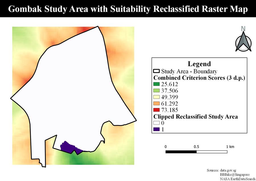
| Recalling from the Criterion Score Map Layout of the Four Factors, in which all their scales followed 0 to be FAVOURABLE and 1 to be UNFAVOURABLE, this map's scale would be interpreted in a similar fashion, in which the lower the values, the greater the favourability of that area being suitable for the construction of the CDQC. From this, the suitable areas would like in the yellowish-green color-coded areas in the Raster Map. However, in order to specifically digitize the possible areas for the CDQC, we would need to reclassify the pixel values using a certain range threshold. The Reclassify by Table function was used with this map as its input, using the following reclassification.
The output for the reclassification function was further clipped within the Gombak area boundary via the Clip Raster by Mask Layer function with the reclassification layer and the Gombak area layer as its inputs to return the map view below. |
| RECLASSIFIED RASTER MAP |
|---|
| This map view further shows the suitable area within the Gombak boundaries represented by the Value 1. From this, we know that the suitable area derived would be located in the Southern region of Gombak. In order to derive the area of this site, we need to convert this area into polygons. From this, the Polygonize (Raster to Vector) was used to convert this layer into a vector layer. From the returned output of the function, a new field named Area was created into the Attribute Table of the layer via the Field Calculator. This is used to find out if the suitable area derived from the map fulfill the minimum area requirement of 10,000m2. The following syntax was used to derive the areas of the polygons in the layer.
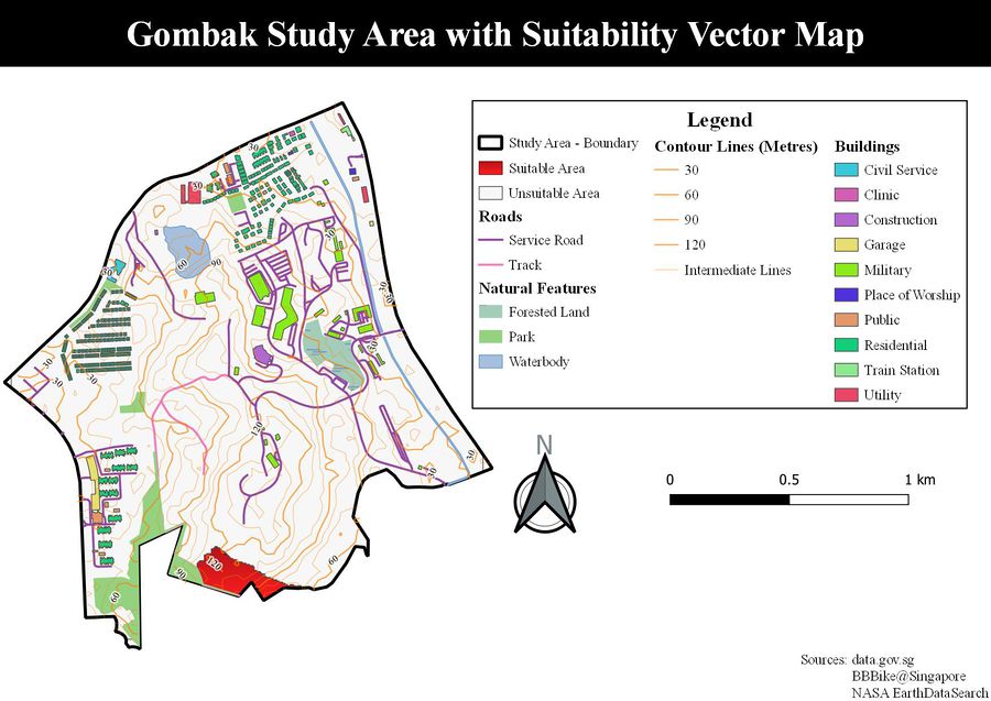
The following map view shows the suitable site derived from the Suitability Maps with the inclusion of Roads, Buildings, Natural Features and Digital Elevation of Gombak. |
| VECTOR MAP |
|---|
| At first glance, the selected suitable area seems to be on elevated terrain from 90 to 120 metres with a park being within its proximity on the West. There is a service road to its North, but the transportation or movement to that road itself would require an assisted vehicular mode of transport or transport infrastructure as the road is near the apex of the elevation of Gombak, in which movement from the site to that road would involve transiting up a slope or hill. However, with the prioritization of the Health Risk Factor, we can clearly see that there are no buildings in close proximity to this site. The following view zooms further into this selected area and the features in its proximity. |
| ABOUT THE LAND LOT |
|---|
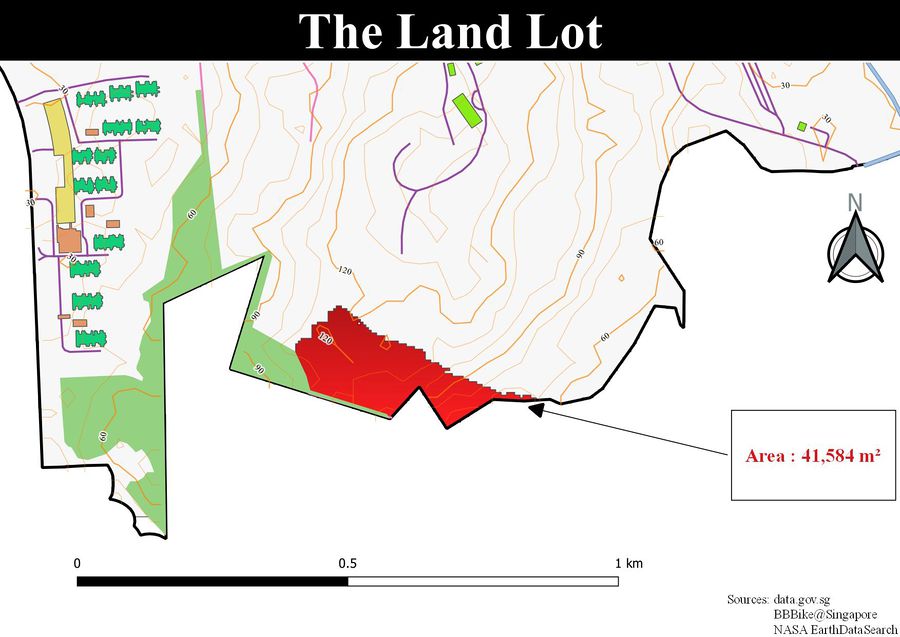
In addition to the full Vector Suitability Map layer view above, the derived suitable site has the following features:
However, if the this selected site were to be finalized as the CDQC in Gombak, there would not only be high developmental costs because of the land terrain, but also further additional costs for the possible investing of more transportation infrastructure to increase its accessibility to the service roads and tracks of Gombak. Moreover, with the park on its West being in close proximity to the site, it does not contribute towards natural conservation. Given the excessive land area for this derived site, we can consider starting the CDQC in a smaller area first and consider its expansion in due time to come. The following shows the suggested area within this site. This area was derived with the Measure Area Tool, in which this newly suggested smaller site for the CDQC still qualifies in terms of the minimum area requirement. Also, it has lower land elevation from 70 to 90 metres, which could possibly save the redevelopmental costs during its construction stage. In addition to the absence of buildings in its close proximity hence limiting any health risks, this area takes into account the natural conservation factor greater than the previous larger area, therefore being more environmentally friendly. We should also take into account that this site is considered when only taking the features and infrastructure within Gombak into account, in which this site could face further changes if the features that are in close proximity of the site but are within the external region of the Gombak boundary is considered. |


