From Geospatial Analytics for Urban Planning
Jump to navigation
Jump to search
|
|
| Line 15: |
Line 15: |
| | [[File:Ex2 Map3 BinarySlope JeromeQuah.jpg|900px|thumb|center|'''Gombak Study Area with Criterion Scores of:<br>- Economic Factor (Top Left)<br>- Health Risk Factor (Top Right)<br>- Natural Conservation Factor (Bottom Left)<br>- Accessibility Factor (Bottom Right)''']] | | [[File:Ex2 Map3 BinarySlope JeromeQuah.jpg|900px|thumb|center|'''Gombak Study Area with Criterion Scores of:<br>- Economic Factor (Top Left)<br>- Health Risk Factor (Top Right)<br>- Natural Conservation Factor (Bottom Left)<br>- Accessibility Factor (Bottom Right)''']] |
| | | | |
| − | used Min-Max for Normalisation | + | |
| | + | <!-- Preface Text --> |
| | + | {| align=center width = 100% |
| | + | |
| | + | | style="text-align:justify; width:20em; height: 1em; font-size:17px; font-family: Times New Roman !important; background-color:ghostwhite; color: black;"|used Min-Max for Normalisation. |
| | + | |} |
| | + | |
| | + | |
| | | | |
| | <!-- Economic Factor Heading --> | | <!-- Economic Factor Heading --> |
Revision as of 02:32, 9 November 2019
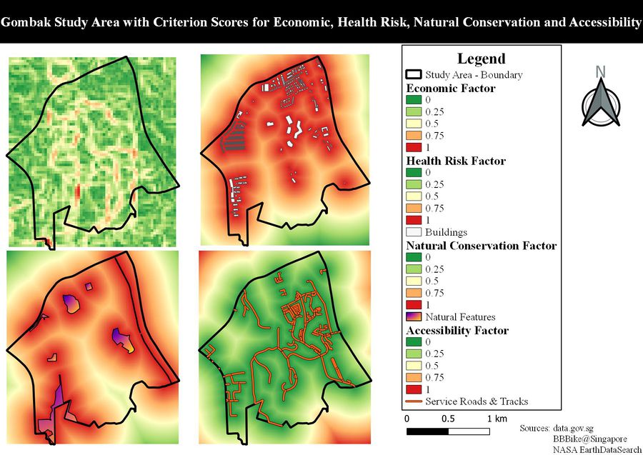
Gombak Study Area with Criterion Scores of:
- Economic Factor (Top Left)
- Health Risk Factor (Top Right)
- Natural Conservation Factor (Bottom Left)
- Accessibility Factor (Bottom Right)
| used Min-Max for Normalisation.
|
| From the Slope Layer (Bottom Right), similar to the Digital Elevation - Contour Lines Map View, the degree of the land terrain of Gombak tends to increase when progressing from the North region to the South region of Gombak, in which Gombak Hill is within that proximity. From this, it is in our best interests that we do not consider the Southern areas of Gombak with high slope degrees for the suitable site for building the CQDC in terms of Economic.
|
| HEALTH RISK FACTOR (BUILDINGS)
|
| From the Slope Layer (Bottom Right), similar to the Digital Elevation - Contour Lines Map View, the degree of the land terrain of Gombak tends to increase when progressing from the North region to the South region of Gombak, in which Gombak Hill is within that proximity. From this, it is in our best interests that we do not consider the Southern areas of Gombak with high slope degrees for the suitable site for building the CQDC in terms of Economic.
|
| NATURAL CONSERVATION FACTOR (NATURAL FEATURES)
|
| From the Slope Layer (Bottom Right), similar to the Digital Elevation - Contour Lines Map View, the degree of the land terrain of Gombak tends to increase when progressing from the North region to the South region of Gombak, in which Gombak Hill is within that proximity. From this, it is in our best interests that we do not consider the Southern areas of Gombak with high slope degrees for the suitable site for building the CQDC in terms of Economic.
|
| ACCESSIBILITY FACTOR (ROADS)
|
| From the Slope Layer (Bottom Right), similar to the Digital Elevation - Contour Lines Map View, the degree of the land terrain of Gombak tends to increase when progressing from the North region to the South region of Gombak, in which Gombak Hill is within that proximity. From this, it is in our best interests that we do not consider the Southern areas of Gombak with high slope degrees for the suitable site for building the CQDC in terms of Economic.
|
