VAST 2019 MC1: Crowdsourcing for Situational Awareness
Question: Emergency responders will base their initial response on the earthquake shake map. Use visual analytics to determine how their response should change based on damage reports from citizens on the ground. How would you prioritize neighborhoods for response? Which parts of the city are hardest hit? Limit your response to 1000 words and 10 images.
Insights
| Summary
|
Detailed Description
|
| Analysis of Shake Map
|
The source of the earthquake (epicenter) appears to be located near the 12th of July Bridge and Himark Bridge on 6 April 2020. The shaking is weak. However, the shaking got stronger on 8 April and more cities were affected by the earthquake. From the shake map, we can see that the following cities are more likely to be greatly affected by the earthquake. Cities sorted by perceived damage: Old Town, Safe Town, Cheddarford, Pepper Mill, Wilson Forest, Easton, East Parton, West Parton, and Terrapin Springs.
|
| Determine the Time Of The Earthquake
|
Refer to the numbers in the chart to follow along:
The damage type filter is set to Shake Intensity for this analysis.
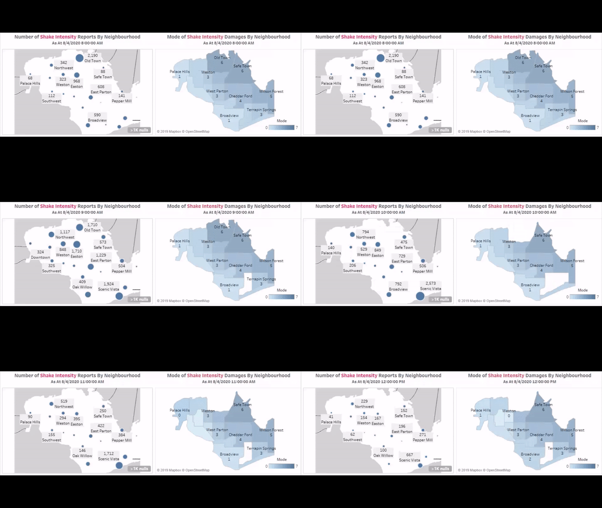
- Citizens from Old Town, Safe Town, Wilson Forest, Terrapin Springs, Pepper Mill, Cheddarford, Easton, East Parton, and West Parton made a high number of reports starting from 8 April, 8 AM. We can conclude that this is the time when the first earthquake started. Do note that records, where the impact score is empty, are filtered out.
- 6939 shake intensity reports were made at 8 AM with Old Town making 31.56% of the total reports.
- On 8 April at 9 AM, 12,998 reports were made with Scenic Vista taking over the top spot and comprise of 14.80% of the total number of reports at that time.
- The number of shake intensity reports start to drop rapidly from 9 AM till about 6 PM on 8 April. The earthquake most likely ended at around 11 AM to 12 PM.
- We can observe a spike in shake intensity reports again on 9 April starting from 3 PM although the earthquake is over. We will investigate this further later on.
|
| Hardest Hit Areas
|
Refer to the numbers in the chart to follow along:
- We can confirm that the earthquake started on 8 April, 8 AM with this dashboard.
- The hardest-hit areas appear to be Old Town, Safe Town, Pepper Mill, and Wilson Forest. This is supported by the shake map analysis since the neighbourhoods are located near to the epicenter of the earthquake and we can expect these neighbourhoods to be more affected by the earthquake.
- We can also identify anomalies in the data for Old Town and Wilson Forest. For Old Town, the neighbourhood is most likely to be greatly affected by the earthquake due to its close proximity to the epicenter, but no reports were made 1 to 2 hours after the earthquake on 8 April, 8 AM. A possible reason was that the earthquake resulted in a power outage and the citizens were unable to report the damages. As for Wilson Forest, the power outage situation appears to be worse since reports were made at the start of the earthquake on 8 April, 8 AM. Before the earthquake, no reports were made except for 6 April, 2 PM. (The other data points before the earthquake have Null shake intensity impact scores)
- On 8 April, Old Town, Safe Town, and Pepper Mill are consistently the top 3 cities with the highest number of reports with an impact level of strong, very strong and severe. This is supported by the average shake intensity chart with the 3 cities having a high average shake intensity score as compared to the other cities.
- Old Town is the hardest-hit city. Set the filter of ‘Select Neighbourhood’ to Old Town and we can see that the maximum shake intensity for Old Town on 8 April, 8 AM is 9 out of 10!
|
| Emergency Response Planning
|
From the shake intensity charts, we can deduce that the following cities need more help from 8 April, 8 AM to 11 AM: Old Town, Safe Town, Pepper Mill, and Wilson Forest as identified above. The team should respond to these cities. The number of reports made by neighborhood chart also shows that areas that are hardest hit may not always have a high number of reports and vice-versa. Therefore, using the mode of the impact score seems to be a better option in assessing the extent of the damage instead of solely using the number of reports in our analysis.
|
| Prioritization
|
The time frame for this analysis will be 8 April 8 AM to 11 AM. The hardest-hit areas identified in the previous dashboards are Old Town, Safe Town, Pepper Mill, and Wilson Forest. Taking this into consideration, we can further analyze the intensity of each damage type across the city in this dashboard. Do note that Wilson Forest is considered a high priority area despite the lack of reports.
An assumption made is that the emergency response team comprise of different divisions and responders are specialized or trained to deal with a specific damage type. The following cities should receive a higher priority:
| Damage Type |
High Priority Neighbourhoods |
Rationale
|
| Buildings |
Broadview, Old Town and Wilson Forest. |
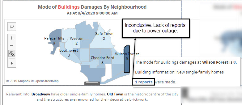
Broadview has older-single family homes known for their architectural styles and masonry construction. It is also a great place to raise a family. We can assume that the people who live here are either old or live together as a family. Since the buildings are old, it is logical to conclude that the buildings and the people are prone to experience greater damage. As for Old Town, they are the hardest-hit area and it is a historic center. Wilson Forest also showed a high mode for building damages of 8 at 9 AM but this is based on only one report which is not conclusive enough. The team should focus on Broadview and Old Town first.
|
| Medical |
Palace Hills, Old Town, East Parton and Terrapin Springs. |
|
| Power |
Old Town, Wilson Forest, and Chapparal |
The team can work with the St. Himark Power department. The Always Safe Nuclear Power Plant provides 72% of St. Himark’s electricity. It located in Safe Town which is one of the hardest-hit areas. The mode for power damages in Safe Town is about 3. However, it is crucial for the team to restore power since it can affect the recovery efforts (e.g. Some hospitals like the Community Hospital in Broadview have a high mode impact score for power).
|
| Roads and Bridges |
Palace Hills, Old Town and Wilson Forest |
Example
|
| Sewer and Water |
Broadview, Old Town and Terrapin Springs |
Example
|
|
Conclusion


