IS428 AY2019-20T1 Assign Christine Anomalies Observation
Contents
- 1 Q1. Visualize radiation measurements over time from both static and mobile sensors to identify areas where radiation over background is detected. Characterize changes over time.
- 2 Q2. Use visual analytics to represent and analyze uncertainty in the measurement of radiation across the city.
- 2.1 Q2a. Compare uncertainty of the static sensors to the mobile sensors. What anomalies can you see? Are there sensors that are too uncertain to trust?
- 2.2 Q2b. Which regions of the city have greater uncertainty of radiation measurement? Use visual analytics to explain your rationale.
- 2.3 Q2c. What effects do you see in the sensor readings after the earthquake and other major events? What effect do these events have on uncertainty?
- 3 Q3. Given the uncertainty you observed in question 2, are the radiation measurements reliable enough to locate areas of concern?
- 3.1 Q3a. Highlight potential locations of contamination, including the locations of contaminated cars. Should St. Himark officials be worried about contaminated cars moving around the city?
- 3.2 Q3b. Estimate how many cars may have been contaminated when coolant leaked from the Always Safe plant. Use visual analysis of radiation measurements to determine if any have left the area.
- 3.3 Q3c. Indicated where you would deploy more sensors to improve radiation monitoring in the city. Would you recommend more static sensors or more mobile sensors or both? Use your visualization of radiation measurement uncertainty to justify your recommendation.
- 4 Q4. Summarize the state of radiation measurements at the end of the available period. Use your novel visualizations and analysis approaches to suggest a course of action for the city. Use visual analytics to compare the static sensor network to the mobile sensor network. What are the strengths and weaknesses of each approach? How do they support each other?
- 5 Q5. The data for this challenge can be analyzed either as a static collection or as a dynamic stream of data, as it would occur in a real emergency. Describe how you analyzed the data - as a static collection or a stream. How do you think this choice affected your analysis?
Q1. Visualize radiation measurements over time from both static and mobile sensors to identify areas where radiation over background is detected. Characterize changes over time.
STATIC SENSOR READINGS
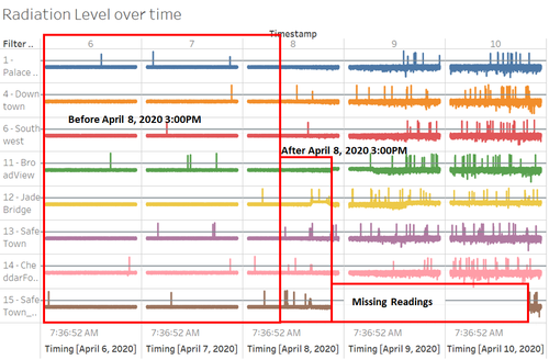
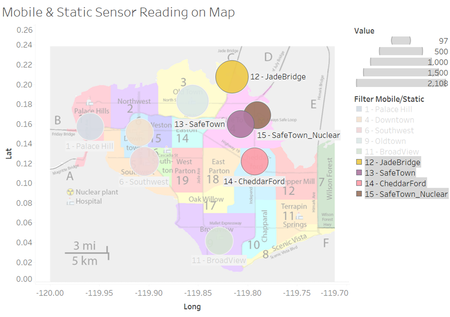
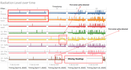
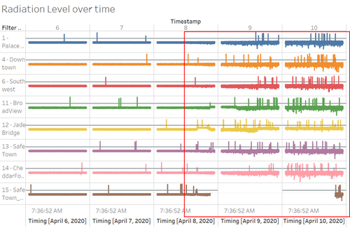
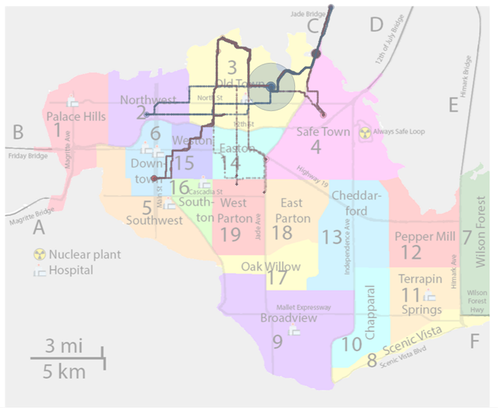
In terms of radiation level, healthy reading level was set at 75cpm (Watts, A. et al., 2011), when any sensor readings that exceed this healthy level; attention need to be given to the respective sensor before it reaches warning level at 100cpm. Based on the readings, before 8 April 2020 03:00PM, radiation level shows minor fluctuation (relatively stable in terms of changes in reading); however, after 8 April 2020 03:00PM, there are significant spikes of radiation readings spotted across all sensors but especially sensor 12-JadeBridge, 13-SafeTown, 14-CheddarFord, and 15-SafeTown_Nuclear have the noisiest spikes among other sensors on this day. This was possibly due to these sensors are located nearest to the power plant especially sensor 13-SafeTown and 15-SafeTown_Nuclear located in the region of Safe Town – location of Always Safe Nuclear power plant. So that when earthquake is happening, those sensors are affected the most.
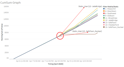
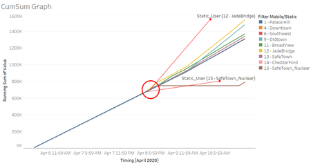
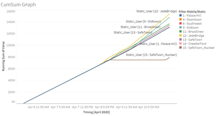
Additionally, from Cumulative Sum of radiation readings, we can clearly identify the first few sensors that show abnormal spikes in radiation readings are sensor 12-JadeBridge at 8 April 2020 3:00PM and 15-Safe Town_Nuclear at 8 April 2020 4PM.
MOBILE SENSOR READINGS
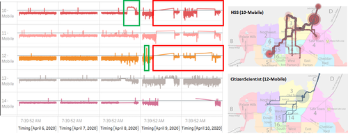
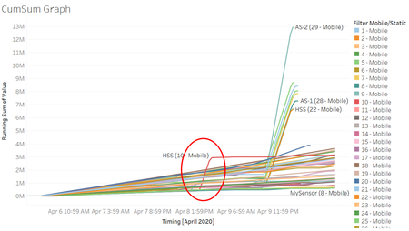
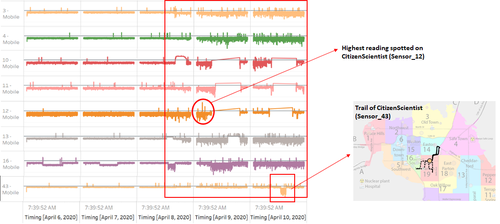
As compared to static sensor, mobile sensor HSS(10-Mobile) show high spike above healthy level (75cpm) between 8 April 2020 4:37PM until 10:00PM where at this period the sensor’s trail passed Jade Bridge (Green box on Figure 1.4) and based on Figure 1.5, HSS(10-Mobile) is the first sensor that show high spike of radiation reading. Aside from HSS (10-Mobile), there is another sensor that pass Jade Bridge at this period, CitizenScientist(12-Mobile) also show similar pattern in radiation readings which shows that there are contaminations at Jade Bridge. On top of that, CitizenScientist(12-Mobile) show short period highest spike of radiation reading on 9 April 2020 02:43AM (Green box on Figure 1.4). Aside from these findings, both HSS(10-Mobile) and CitizenScientist(12-Mobile) located at Old Town, then travelled to Jade Bridge and surrounding. At the end of readings, both sensors come back to Old Town; this suggest that there are contaminations at Jade Bridge.
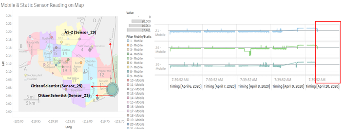
However, on 9 April 2020 08:02PM; readings show high readings for CitizenScientist(21-Mobile), CitizenScientist(25-Mobile), and AS-2(29-Mobile) with AS-2(29-Mobile) is the highest; but after 10 April 2020 06:35:35PM, all three sensors’ readings are starting to disappear sequentially from AS-2(29-Mobile), CitizenScientist(25-Mobile), and CitizenScientist(21-Mobile).
Q2. Use visual analytics to represent and analyze uncertainty in the measurement of radiation across the city.
Q2a. Compare uncertainty of the static sensors to the mobile sensors. What anomalies can you see? Are there sensors that are too uncertain to trust?
STATIC SENSORS' READING
Before 8 April 2020 3:00PM; almost all static sensors show stable readings. While the most obvious anomalies detected in this case is the missing readings of sensor 15-SafeTown_Nuclear after 8 April 2020 10:06:25PM. In addition, notable that after 8 April 2020 10:06:25PM, sensor 15-SafeTown_Nuclear has some missing readings but the readings start to appear again on 10 April 2020 8:47PM. Some possible reason could be due to location sensor 15-SafeTown_Nuclear that located near to the power plant. Another notable finding is that the first few sensors that show the most obvious spikes after 8 April 2020 3:00PM are sensor 15-SafeTown_Nuclear and 12-JadeBridge which means that during the earthquake, these two regions are affected the most by the contamination level.
Additionally, while sensor 1-PalaceHill, 4-DownTown, and 12-JadeBridge shows smaller spikes (more consistent readings) during the period before 9 April 2020. In contrast, 15-SafeTown_Nuclear shows noisier readings during this period especially on 8 April 2020. This may be affected by the different environmental condition where 15-SafeTown_Nuclear is located directly on the vicinity of power plant (Safe Town). The consistency in recording the readings also suggest that static sensors overall are reliable in providing radiation levels based on the surrounding environment.
MOBILE SENSORS' READING
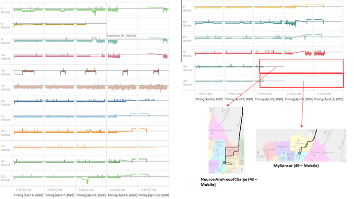
Based on the observation, I found that most of mobile sensors’ reading will have some intermittent break of missing values which can be understood that during the start of each day (midnight) and end of each day (midnight), cars won’t be moving around and readings will stop. However, there are some sensors with more missing readings than other sensors as follow: mobile sensor 5, 6, 9, 14, 18 to 25, 27 to 30, 48, and 49. The possible reason that sensors stop reading was because they left the map zone, for example on the sensor NeutronsAreFreeOfCharge(48-Mobile) and MySensor(49-Mobile) where both of sensors left the map - NeutronsAreFreeOfCharge(48-Mobile) left Himark Bridge and MySensor(49-Mobile) left Jade Bridge at sensor’s reading period around 8 April 2020 7:00AM.
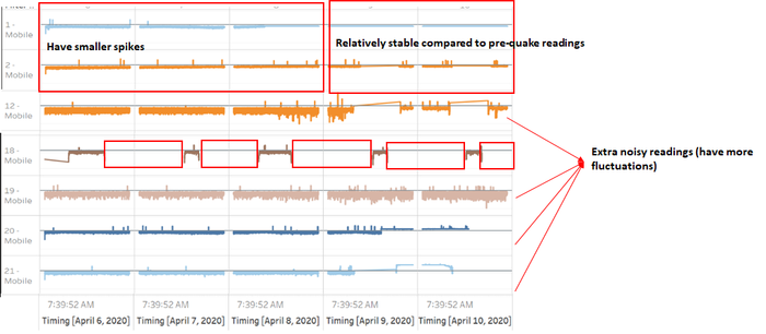
Let’s take an example of sensor HiMarkHS(18-Mobile) and CitizenScientist(20-Mobile), both sensors’ readings show anomalies in terms of missing value and extra noisy background contamination. On sensor HiMarkHS(18-Mobile), the intermittent reading is more frequent and more missing data spotted; while sensor CitizenScientist(20-Mobile) shows extra noisy background (more fluctuation in readings that ove); aside from these two sensors, other sensors that show extra noisy background are CitizenSceintist sensor 12, 19, and 21.
On top of those extra noisy sensors and missing value, one notable point that we can observe the anomalies are sensor MySensor(1-Mobile) and TestUnit(2-Mobile) where the distribution of the readings of pre-quake readings have some spikes / fluctuation spotted but after earthquake, the readings show a relatively stable readings as compared to other sensors.
By considering these anomalies, we can conclude that some possible sensors that should be treated with caution will be sensor 1, 2, 12, 19, 20, and 21.
Q2b. Which regions of the city have greater uncertainty of radiation measurement? Use visual analytics to explain your rationale.
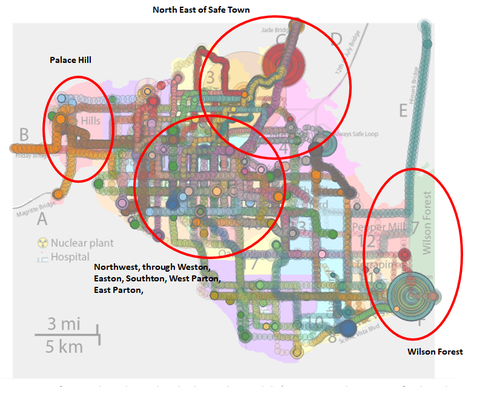
Based on the Mobile Sensor map readings, there are several regions/areas that show diverse/heterogeneous readings that are unlikely due to environmental causes and the vicinity of the power plant. Some regions/areas in the diverse readings such as North East of Safe Town, Wilson Forest (excluding the highway), and Palace Hills. The unreliable sensor at Safe Town is sensor CitizenScientist(15-Mobile) that mentioned previously. Sensor CitizenScientist(15-Mobile) is located near the power plant but has a certain period of missing readings. Hence, it is not contributing to the reliable readings of the level of contamination.
While for Wilson Forest, we can observe that the mobile sensors are very far from the affected region, yet sensor AS-2(29-Mobile) recorded a very high spike reading on 09 April 2020 7:00 PM – 9:00 PM, which means that it was unlikely to be affected by the environment (possible of contamination outside the map) which made sensor in this area is not reliable.
In addition, area such as Northwest, through Weston, Easton, Southton, West Parton, East Parton, and Palace Hill show diverse readings / erroneous fluctuation that was unlikely due to environmental causes since most cars will pass those areas (high density) which made the reading have possible cross-contamination. While Palace Hill is near to the exit Friday Bridge, this also means that these areas show a great uncertainty with the sensor readings.
The largest spike at Old Town also should be treated with caution as well due to the high spike in a short period of time; however, after the high spike, it returns to average readings which show that the readings in Old Town are not sustainable and reliable.
Q2c. What effects do you see in the sensor readings after the earthquake and other major events? What effect do these events have on uncertainty?
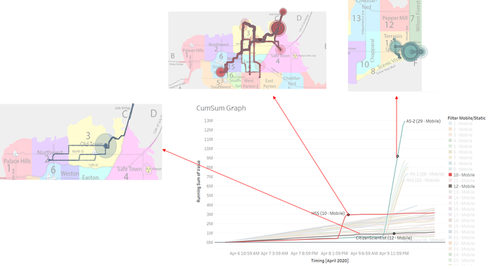
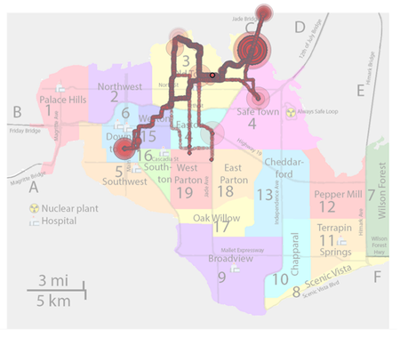
From the graph, we can observe that there are general increases for most sensors from 8 April 2020 3:00PM onwards, especially some few first spikes of Static sensors (Sensor 12-JadeBridge and Sensor 15-SafeTown_Nuclear) and Mobile sensors HSS(10-Mobile) that located at Old Town (Figure 2.6). Due to most of first few spikes happened at this period; it can be concluded that earthquake happened around this period, 8 April 2020, 3:00PM (Figure 2.7).
More specifically, we can observe that after earthquake, there are increasing in spike frequency on mobile sensor 3, 4, 10-13, and 16, but most spikes / fluctuations observed was still below the healthy level (75cpm) as compared to readings before earthquake. Additionally, there is an interesting reading of CitizenScientist(43-Mobile) around 10 April 2020 12:00PM that shows there is a sudden drop for a short period of time. After tracing the trail of CitizenScientist(43-Mobile) at 10 April 2020 5:00PM when the reading is increasing again, it shows no obvious environmental cause detected since it only moves around Southton, Easton, and West Parton.
Notably, CitizenScientist(12-Mobile) shows the highest log value which means having greater proportion of very low values than most sensors. This means that with the varying of spike frequency and readings value, it will decrease the confidence of recorded values.
Q3. Given the uncertainty you observed in question 2, are the radiation measurements reliable enough to locate areas of concern?
Q3a. Highlight potential locations of contamination, including the locations of contaminated cars. Should St. Himark officials be worried about contaminated cars moving around the city?
Potential areas of those contaminated cars are Jade Bridge, Wilson Forest Highway, and potentially Old Town. From Figure 3.1, we can observe that HSS(Sensor_10) contribute to main contamination from 8 April 2020 04:37PM to 10:00PM; sensor AS-2(29-Mobile) contribute to main contamination from 9 April 2020 06:00PM to 9 April 2020 06:00AM; while last potential region, Old Town is contributed by CitizenScientiest(12-Mobile) where large contamination spotted on 9 April 02:43PM. However, as mentioned in question 2, sensor CitizenScientiest(12-Mobile) is identified as a sensor that has high degree of uncertainty which made the reading not reliable. Hence, St. Himark should worry about the contaminated cars that pass through Jade Bridge, Wilson Forest Highway; but for Old Town due to the reliability of readings, we can only conclude that this area is potentially to be contaminated as well.
Q3b. Estimate how many cars may have been contaminated when coolant leaked from the Always Safe plant. Use visual analysis of radiation measurements to determine if any have left the area.
JADE BRIDGE
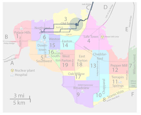
HSS(10-Mobile) shows the high readings that believed it was strongly affected by the contamination that can be seen from 8 April 2020 04:37 PM to 10:00 PM. Trail of HSS(Sensor_10) shows that it moved around Old Town and Jade Bridge. If observed from the trails’ record, it is noticeable that CitizenScientist(Sensor_12) has a similar / overlap path (Figure 3.4) as HSS(10-Mobile) and both sensors will eventually left the map through Jade Bridge at end of the day of 10 April 2020. Additionally, due to a similar path for both sensors, the radiation readings also show a similar pattern that can be seen from Figure 3.5. This suggests that there is some possibility of cross-contamination between these two cars.
WILSON FOREST HIGHWAY
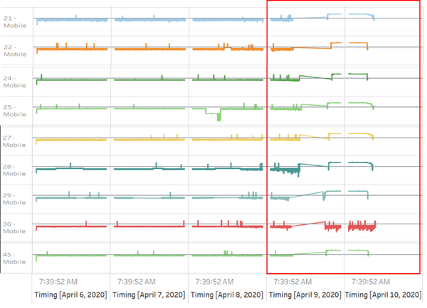
From the graph, we can observe there are some possible contaminated cars/sensors that have similar readings pattern and contamination periods. Those sensors are 21, 22, 24, 25, 27, 28, 29, 30, and 45. Even though there is a little difference between sensor PeterLovesCrystals54(30-Mobile) and the rest, but in terms of the contamination pattern and period still similar. It just that PeterLovesCrystals54(30-Mobile) at lower readings and below the healthy level (75cpm) compared to the rest.
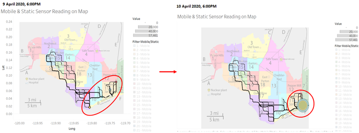
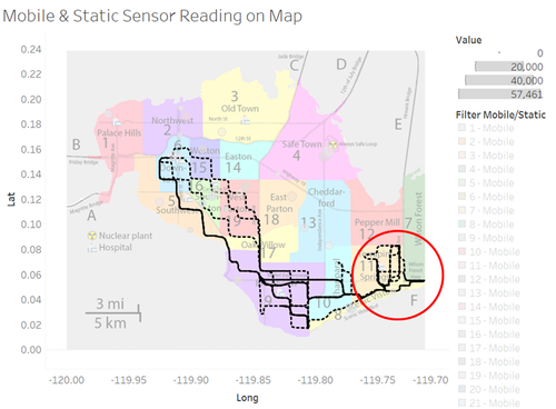
In instance, we took sensor 27, 28, 29 and 30 as example at two different point of time to see the movement. On 9 April 2020 06:00AM, all four sensors are respectively at four points and starting to show similar pattern in terms of reading. However, when on 10 April 2020, 06:00PM, it shows that all four sensors located near to the Wilson Forest Highway and readings at this timing show extremely high until all left the map through Wilson Forest Highway by the end of day 10 April 2020.
Hence, in total for both contaminated areas, there are 11 contaminated cars identified.
Q3c. Indicated where you would deploy more sensors to improve radiation monitoring in the city. Would you recommend more static sensors or more mobile sensors or both? Use your visualization of radiation measurement uncertainty to justify your recommendation.
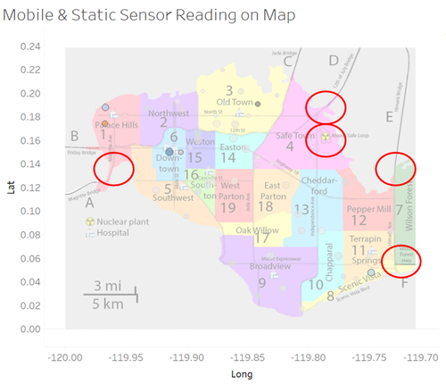
Based on the observation of previous questions, it shows that Mobile sensor have higher chance of contamination due to cars moving to contaminated area and bring the radiation to the clean area. Hence, I suggest of having new static sensors implemented as static sensor provide higher accuracy and reliability as compared to Mobile sensor. Those uncovered areas / regions previously that have high chance of contamination should be focus on such as sensors in the proximity of power plant and exit routes as follow: Magritte Bridge, 12th July Bridge, Himark Bridge, and Wilson Forest Highway.
Q4. Summarize the state of radiation measurements at the end of the available period. Use your novel visualizations and analysis approaches to suggest a course of action for the city. Use visual analytics to compare the static sensor network to the mobile sensor network. What are the strengths and weaknesses of each approach? How do they support each other?
By observing the two cumulative sum graphs, I will suggest some course of actions as follow:
- We can observe that all static sensors have a consistent increment in background radiation level which almost doubling the normal radiation level.
- Based on the static sensor, the graph shows that two regions at Jade Bridge and Old Town have the highest contamination level and some possible reason that Old Town was high in reading because it located right at the entrance of Jade Bridge. The priority should be given to these two areas for decontamination and Jade Bridge should be closed until no radiation level was detected.
- While for mobile sensors, cars (Sensor 21, 22, 24, 25, 27, 28, 29, 30, and 45) that pass-through Wilson Forest Highway shows high readings which indicate that there is a risk of those cars to contaminate other clean areas. Hence, these cars that pass Wilson Forest Highway should be located as a priority for decontamination.
In terms of the difference between Static and mobile sensors, we can say that the static sensor provides more reliable reading but with less comprehensive coverage due to its fixed location. However, at the same time due to its fixed location, the Static sensor is useful in detecting the contamination sources. While the other side, the mobile sensors could move around which have more comprehensive coverage, but at the same time, mobile sensors could be the vector of contamination due to the function of a car that could possibly bring the contaminated particle into clean areas. However, due to this mobility, the mobile sensor could detect the radiation level outside St Himark while static sensors would not able to cover. In addition, the mobile sensor could effectively demonstrate the severity of radiation, but the drawback located at the inconsistent and unreliability of readings. In conclusion, we can observe that both Static and Mobile sensors have their own performing advantage and constraint; what mentioned above shows that both sensors could support each other in have different areas of coverage.
Q5. The data for this challenge can be analyzed either as a static collection or as a dynamic stream of data, as it would occur in a real emergency. Describe how you analyzed the data - as a static collection or a stream. How do you think this choice affected your analysis?
Initially, data were analyzed as a static collection. However, stream collection of data is needed when the analysis is conducted. In this case, no time-based calculation required processed data in the stream which means that the timeline-based layout is amenable to constant streaming.
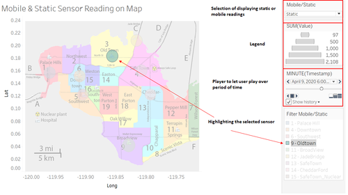
In instance, cumulative sum graph was used because we just need to have assumed stable background rate which to compare with real time rates. It is useful in detecting the early spikes / fluctuation of the readings; and suitable for the condition that required emergency response the moment any noisy data detected. Some additional feature can be added such as the selection between displaying mobile or static data with legend provided (Figure 5.2). Additionally, it will be useful to be able to monitor behaviour of sensor and detect the pattern of readings even path (for mobile sensor) that they passed through. In this case, map graph with interactive slider / player that allows user to monitor the changes of reading over time and trace the path will be useful to detect what could be the possible affecting factors besides environmental causes.
