 Sofia City's Air Pollution Problem Analysis
Methodology & Dashboard Design
Methodology
| Description |
Illustration |
| 1.Time Frame
The Time Frame is adjust to daily and hourly to provide a better pictorial oversight on the trends as well as looking out for hidden insights. The data will be illustrated using heat map.
|
|
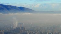
| 2.Identifying the stations versus geographical location
Understanding the locality of the stations to ensure relevant data are being captured. We only want to capture the information taken by stations located within the Sofia city to provide an accurate illustration of the situation.
Also, based on the stations' location we will refer to the geographical data to see if there is any connection. We hope that geographical data can give us some connections to the pollution information recorded.
|
|
| 3.Connection Pollution and Meteorological Data
We will break down the data sets by seasonality. The data sets will be broken down using cycle plot before identifying for trends.
|
|
 Sofia City's Air Pollution Problem Analysis