Difference between revisions of "Mandi Assignment Final Answer"
Jump to navigation
Jump to search
VAST Challenge 2017 MC 3
| Line 23: | Line 23: | ||
'''2. Features in the Preserve area as captured in the imagery.''' <br /> | '''2. Features in the Preserve area as captured in the imagery.''' <br /> | ||
| + | Most of the images have sensor artifacts at the bottom right corner. | ||
To identify the features in the Preserve Area, I picked the image which is generated from the data [image11_2016_09_06.csv]. It has no sensor artifacts at all. | To identify the features in the Preserve Area, I picked the image which is generated from the data [image11_2016_09_06.csv]. It has no sensor artifacts at all. | ||
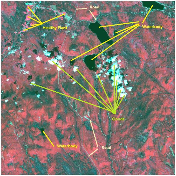
Band combinations(B4, B3, B2) are mapped to the RGB image channels to create the false-color image as below.<br /> | Band combinations(B4, B3, B2) are mapped to the RGB image channels to create the false-color image as below.<br /> | ||
| − | [[File:2016 09 06 Changes PlantHealth.jpeg| | + | [[File:2016 09 06 Changes PlantHealth.jpeg|600px]]<br /> |
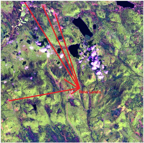
Band combinations(B5, B4, B2) are mapped to the RGB image channels to create the false-color image as below:<br /> | Band combinations(B5, B4, B2) are mapped to the RGB image channels to create the false-color image as below:<br /> | ||
| − | [[File:2016 09 06 Floods newLands.jpeg|650px| | + | [[File:2016 09 06 Floods newLands.jpeg|650px|600px]]<br /> |
With the NDVI and RVI Value, we can identify the different vegetation. <br /> | With the NDVI and RVI Value, we can identify the different vegetation. <br /> | ||
[[File:NDVI NIR.jpg|1200px]]<br /> | [[File:NDVI NIR.jpg|1200px]]<br /> | ||
| Line 35: | Line 36: | ||
* Cluster 4: Waterbody. | * Cluster 4: Waterbody. | ||
* Cluster 5: Clouds. | * Cluster 5: Clouds. | ||
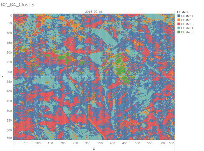
| − | [[File:B2 B4 Cluster.jpg| | + | [[File:B2 B4 Cluster.jpg|700px]] |
<br /> | <br /> | ||
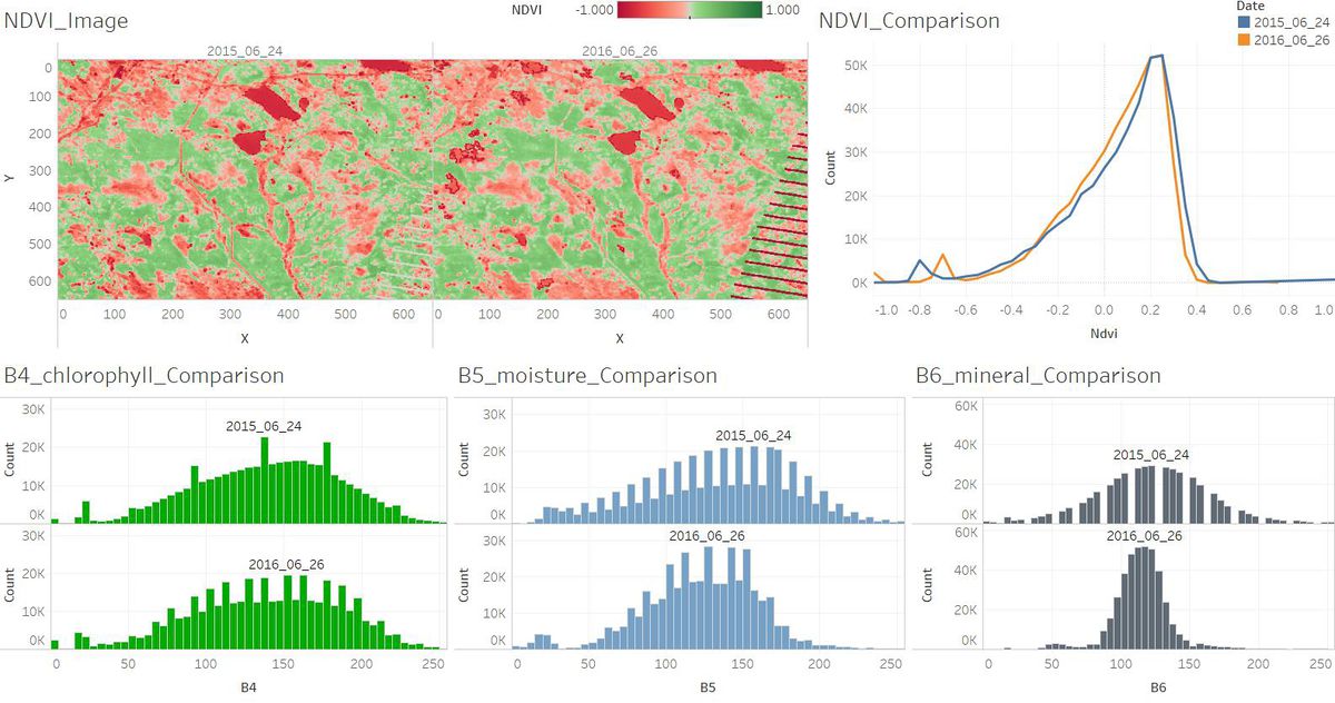
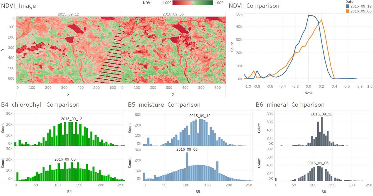
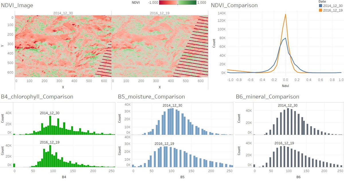
| − | '''3. Features that change over time in these images.''' | + | '''3. Features that change over time in these images.''' <br/> |
| + | [[File:Jun.jpg|1200px]] <br /> | ||
| + | [[File:Sep.jpg|1200px]] <br /> | ||
| + | [[File:Dec.jpg|1200px]] <br /> | ||
Revision as of 22:37, 7 July 2017
Questions:
1. The scale and orientation of the supplied satellite images.
2. Features in the Preserve area as captured in the imagery.
Most of the images have sensor artifacts at the bottom right corner.
To identify the features in the Preserve Area, I picked the image which is generated from the data [image11_2016_09_06.csv]. It has no sensor artifacts at all.
Band combinations(B4, B3, B2) are mapped to the RGB image channels to create the false-color image as below.
Band combinations(B5, B4, B2) are mapped to the RGB image channels to create the false-color image as below:
With the NDVI and RVI Value, we can identify the different vegetation.

- Cluster 1: Common vegetation.
- Cluster 2: Road/Newly Land.
- Cluster 3: Healthy Plant which has absorbed the red light strongly.
- Cluster 4: Waterbody.
- Cluster 5: Clouds.
