ISSS608 2016-17 T3 Assign WEI YUNNA
Yunna Wei - ISSS608 Visual Analytics and Applications_Assignment1
|
|
|
|
|
|
|
Background
|
Mistford is a mid-size city is located to the southwest of a large nature preserve. The city has a small industrial area with four light-manufacturing endeavors. Mitch Vogel is a post-doc student studying ornithology at Mistford College and has been discovering signs that the number of nesting pairs of the Rose-Crested Blue Pipit, a popular local bird due to its attractive plumage and pleasant songs, is decreasing! The decrease is sufficiently significant that the Pangera Ornithology Conservation Society is sponsoring Mitch to undertake additional studies to identify the possible reasons. The Boonsong Lekagul Nature Preserve is used by local residents and tourists for day-trips, overnight camping or sometimes just passing through to access main thoroughfares on the opposite sides of the preserve. The entrance booths of the preserve are monitored in order to generate revenue as well as monitor usage. Vehicles entering and exiting the preserve must pay a fee based on their number of axles (personal auto, recreational trailer, semi-trailer, etc.). This generates a data stream with entry/exit timestamps and vehicle type. There are also other locations in the part that register traffic passing through. |
Data Description
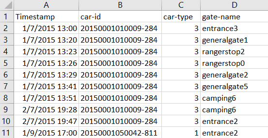
CSV File
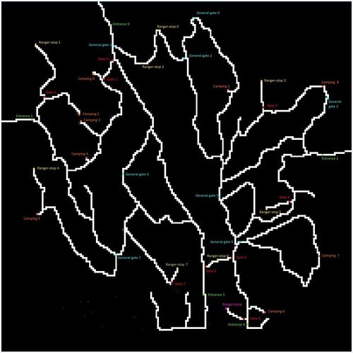
There is a csv file containing data recorded from sensors around the Boonsong Lekagul Nature Preserve. You will also be supplied with a map containing the locations of roadways and sensors throughout the Preserve. Traffic enters and exits the Preserve through official Entrances. There are several Campgrounds where both day-camping and overnight camping are allowed. There are certain roadways restricted to the Preserve Rangers only. The Preserve Rangers are monitoring traffic through various segments of the Preserve, so other sensors are found in various other locations.When vehicles enter the Preserve, they must proceed through a gate and obtain a pass. The gate categorizes vehicles as follows:
- 1:2 axle car (or motorcycle)
- 2:2 axle truck
- 3:3 axle truck
- 4:4 axle (and above) truck
- 5:2 axle bus
- 6:3 axle bus
Vehicles receiving a pass with a “P” appended to their category are park service vehicles that have access to all parts of the Preserve. Currently, the Preserve vehicles are only 2 axle trucks, so they are designated as “2P” vehicle type.
Map
There are five types of sensors recording data:
- Entrances:All vehicles pass through an Entrance when entering or leaving the Preserve.
- General-gates:All vehicles may pass through these gates. These sensors provide valuable information for the Preserve Rangers trying to understand the flow of traffic through the Preserve.
- Gates:These are gates that prevent general traffic from passing. Preserve Ranger vehicles have tags that allow them to pass through these gates to inspect or perform work on the roadway beyond.
- Ranger-stops:These sensors represent working areas for the Rangers, so you will often see a Ranger-stop sensor at the end of a road managed by a Gate. Some Ranger-stops are in other locations however, so these sensors record all traffic passing by.
- Camping:These sensors record visitors to the Preserve camping areas. Visitors pass by these entering and exiting a campground.


