SMT201 AY2019-20T1 EX2 Ho Wei Jie Clint Proximity
TAKE HOME 2: National Communicable Disease Quarantine Centre - Gombak
Contents
Proximity to Target Roads
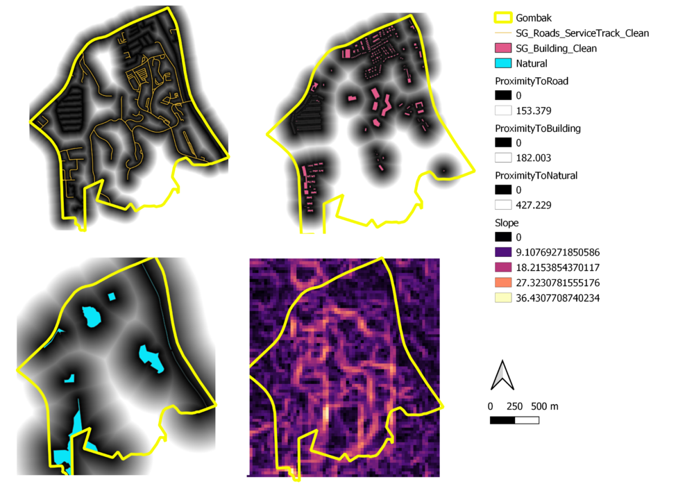
Shown in the top left picture. The dark regions (Black) represents the proximity, between 0 to 153.379m, to the roads and the lighter region (White) represents the distance of at least 153.379m away from the roads. It is observed that the Southern part represents a larger portion of lighter regions which implies that roads are at further away, by at least 153.379, potentially affecting the accessibility of the Southern part of Gombak.
Proximity to Buildings
Shown in the top right picture. The darker regions represent the proximity, between 0 to 182.003, to the roads and the lighter region represents the distance of at least 182.003m away from buildings. As it is important for the quarantine centre to be located further away from buildings, it would be more suitable for the centre to be located at nearer to the southern end of Gombak which shows a lighter region (further away from buildings).
Proximity to Natural Features
Shown in the bottom left picture. The darker region represent the proximity, between 0 to 427.229m, to natural features and the lighter region represents the distance of at least 427.229m away from natural features. The lighter region is mainly located around the southern (right-side) of Gombak. Hence, it might be more ideal that the quarantine centre be located around the southern (right-side) of Gombak as it is important to be away from forested land, parks and water.
Slope
It is observed that the slope ranges from 0 to 36.43 degrees and that most of the current building and roads in Gombak fall under 0 to 18.21 degrees of steepness from where they are currently located. This could possibly imply that Gombak in general is ideal for building a quarantine centre given that majority of the map shows a 0 to 18.21 degree of steepness which current buildings and roads are built upon.
