Kim Chang Heon Ex2 Recommendation
| OVERVIEW | PROXIMITY MAPS | CRITERION SCORES | AHP | RECOMMENDATION |
|---|
| Recommendations |
|---|
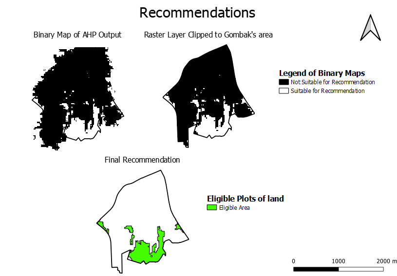
| From the AHP output, the "Reclassify by Table" was used, such that only areas with a AHP score above 0 would be highlighted, with the rest not being highlighted. This produced a binary layer as shown in the top left map. Then, the layer was clipped to fit into Gombak's planning area as shown in the top right map. The black areas are not suitable for the Quarantine center, while the white areas are suitable.
For the final recommendation, I converted this raster layer into a vector layer by using "Polygonize", as I wanted to use the attribute table to calculate the area of the polygons that were suitable. An attribute "Area" was added, with the value being $area. This allowed each polygon to have an attribute with its respective area. From this, by using a rule-based symbology, consisting of the code "area" >= 10000 and "DN" =1, the eligible areas for the Quarantine center was highlighted out, as shown in the bottom map. As shown, the suitable plots of land are located in the extreme east, west and south of Gombak, away from buildings. These plots of land combine the best balance between being away from buildings, natural features, while being near roads and being on relatively flatter ground. |
