From Geospatial Analytics for Urban Planning
Jump to navigation
Jump to search
Part 1: Thematic Mapping
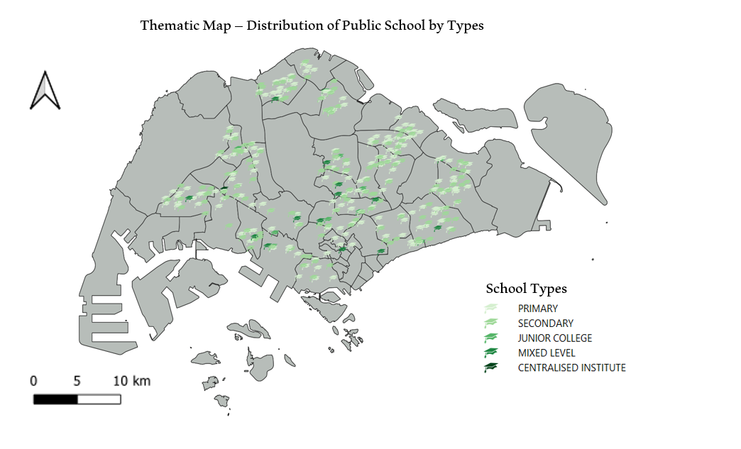
1. The Distribution of Public Education Institution by School Types
- Source of Data : data.gov.sg (general-information-of-schools.csv)
- The graduation hat was chosen to location the schools, as the hat symbolizes education institutions.
- With Primary School being the lightest shade of green, the marker gets darker as the education level goes up. (With the exception for Mixed Level School and Centralised Institute.)
2. The Hierarchy of Road Network System of Singapore
- Source of Data: LTA (RoadSectionLine)
- Different thickness of lines were used to represent the different hierarchy of the roads, along with different shades of colour blue.
- Thicker and darker the lines, the higher the hierarchy of the road is.
- The road classification was done with reference to the table below.
| Road Category |
Types of Roads |
Examples of Street Name Descriptors
|
| Category 1 |
Expressway |
Expressway, Parkway, Highway
|
| Category 2 |
Major Arterial |
Boulevard, Avenue, Way
|
| Category 3 |
Minor Arterial |
Drive, Road, Street
|
| Category 4 |
Primary Access |
Drive, Road, Street
|
| Category 5 |
Local Access |
Walk, Lane, Link, View, Crescent, Terrace, Park, Circle etc.
|
- Because there were no differentiating descriptors for Minor Arterial and Primary Access, they were classified as "Minor Arterial/" as seen on the legend of the map.
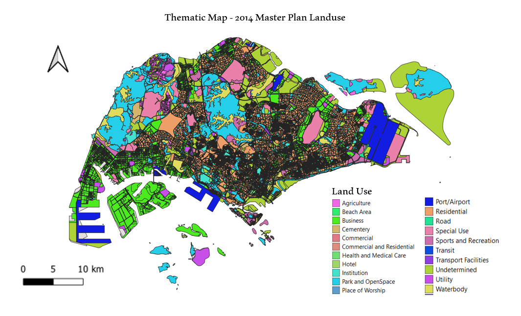
3. 2014 Master Plan Landuse
- Source of Data: data.gov.sg (Master Plan 2014 Subzone Boundary (No Sea))
- There were many fields in the original file. Therefore, the following fields were grouped together under a single legend. The fields that aren't mentioned in the table below were left ungrouped.
| Field Name After Grouping (Legend) |
Grouped Fields From The Original Data Set
|
| Business |
"LU_DESC" in ( 'BUSINESS 1' , 'BUSINESS 1 - WHITE' , 'BUSINESS 2' , 'BUSINESS 2 - WHITE' )
|
| Park and OpenSpace |
"LU_DESC" in ( 'BUSINESS PARK' , 'BUSINESS PARK - WHITE' 'PARK' 'OPEN SPACE' )
|
| Commercial and Residential |
"LU_DESC" in ( 'RESIDENTIAL WITH COMMERCIAL AT 1ST STOREY' , 'COMMERCIAL & RESIDENTIAL' )
|
| Transit |
"LU_DESC" IN ( 'LIGHT RAPID TRANSIT' , ‘MASS RAPID TRANSIT' )
|
| Institution |
"LU_DESC" in ( 'CIVIC & COMMUNITY INSTITUTION' , 'EDUCATIONAL INSTITUTION' , 'RESIDENTIAL / INSTITUTION' )
|
| Undetermined |
"LU_DESC" in ( 'RESERVE SITE' , 'WHITE' )
|


