SMT201 AY2019-20T1 EX1 Goh Jia Xin Genice
Revision as of 15:37, 15 September 2019 by Genice.goh.2018 (talk | contribs) (→Aged Population (65+) in 2010 and 2018)
Contents
Part 1: Thematic Mapping
Part 2: Chloropeth Mapping
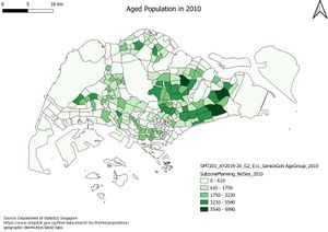
Aged Population (65+) in 2010 and 2018
Aged Population (65+) in 2018
Likewise, I extracted the 2018 Age Group Data from the master file ‘SGPopulationAgeGroupSex’ obtained from Data.gov.sg and cleaned it. I joined the cleaned data with the 2014 Subzone Planning Map and created a new variable called Aged65+, which calculates the number of Singapore Residents who are aged 65 and above. Afterwards, I used graduated categorisation using the variable Aged65+ to create this map.
