Difference between revisions of "SMT201 AY2018-19T1 EX2 Lim Jia Yang James"
| Line 1: | Line 1: | ||
| − | |||
= Gombak National Communicable Disease Quarantine Centre = | = Gombak National Communicable Disease Quarantine Centre = | ||
| Line 16: | Line 15: | ||
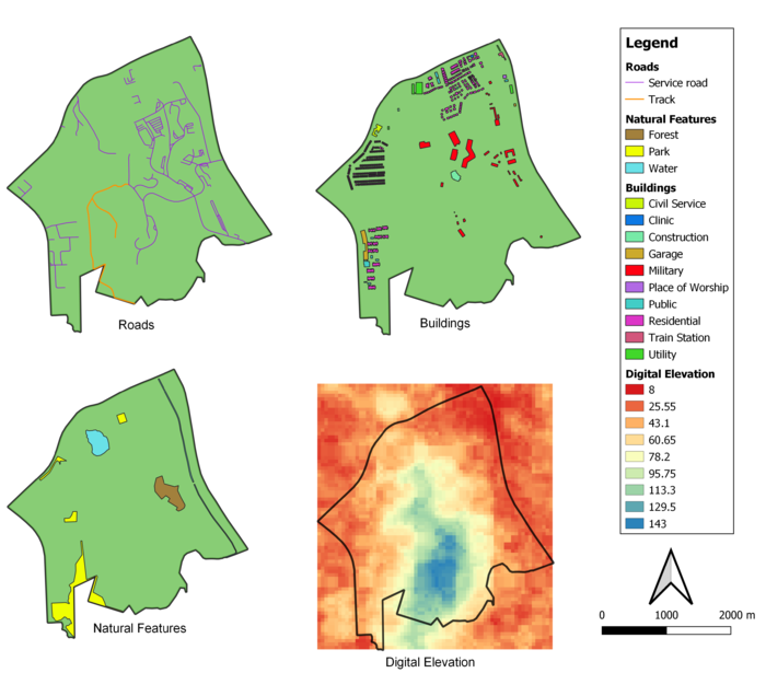
<div class="center" style="width: auto; margin-left: auto; margin-right: auto;">Breakdown Of Gombak And Its Relevant Features </div> | <div class="center" style="width: auto; margin-left: auto; margin-right: auto;">Breakdown Of Gombak And Its Relevant Features </div> | ||
[[File:Map 1 Final James.png|700px|thumb|center|Data Source: Master Plan 2014 Subzone Boundary from URA. Roads, Buildings and Natural Features data from OpenStreetMap. ASTER Global Digital Elevation Model dataset jointly prepared by NASA and METI, Japan. ]] | [[File:Map 1 Final James.png|700px|thumb|center|Data Source: Master Plan 2014 Subzone Boundary from URA. Roads, Buildings and Natural Features data from OpenStreetMap. ASTER Global Digital Elevation Model dataset jointly prepared by NASA and METI, Japan. ]] | ||
| + | |||
| + | |||
| + | === Accessibility Factor (Roads) === | ||
| + | Construction of a National Communicable Disease Quarantine Centre requires a copious amount of construction materials; hence convenient delivery of these materials to the site is essential. Of all the various paths of travel available, only service roads and tracks have been identified as those of use, of which there are 2 and 199 respectively. Tracks are identified in orange and its lines made thicker than service roads, with the purpose of further differentiating itself. It is keen to note that transport to the north-east regions of Gombak will be done mostly by service roads whereas tracks connects to the south-east region | ||
| + | === Health Risk Factor (Buildings) === | ||
| + | |||
| + | === Natural Conservation Factor (Natural Features) === | ||
| + | |||
| + | === Economic Factor (Digital Elevation) === | ||
Revision as of 11:27, 9 November 2019
Contents
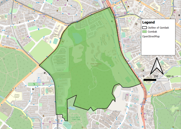
Gombak National Communicable Disease Quarantine Centre
The task was as such- a National Communicable Disease Quarantine Centre had to be constructed in planning subzone Gombak. The contagious area is at least 10,000m2 and it also had to adhere to the following decision factors:
- Accessibility factor: The selected site should be close to existing service roads and tracks.
- Health risk factor: The selected site should be away from population.
- Natural conservation factor: The selected site should be away from forested land, park and water.
- Economic factor: The selected site should avoid steep slope.
Accessibility Factor (Roads)
Construction of a National Communicable Disease Quarantine Centre requires a copious amount of construction materials; hence convenient delivery of these materials to the site is essential. Of all the various paths of travel available, only service roads and tracks have been identified as those of use, of which there are 2 and 199 respectively. Tracks are identified in orange and its lines made thicker than service roads, with the purpose of further differentiating itself. It is keen to note that transport to the north-east regions of Gombak will be done mostly by service roads whereas tracks connects to the south-east region

