Difference between revisions of "G1-Group11 Proposal"
| (7 intermediate revisions by the same user not shown) | |||
| Line 1: | Line 1: | ||
| − | + | [[File:Ang Mo logo.jpg|300px|frameless|center]] | |
| − | + | {| style="margin:auto; padding: 5px 10px 5px 10px;" width="100%"| | |
| − | {| style="margin:auto; padding: | + | | style="text-align: center; border-top:solid #1b2fc4; border-bottom:solid #1b2fc4" width="250px" | [[G1-Group11|<font color="black"><strong>HOME</strong></font>]] |
| − | | style=" | + | | style="text-align: center; border-top:solid #fc7b03; border-bottom:solid #fc7b03" width="250px" | [[G1-Group11 Proposal|<font color="black">PROPOSAL</font>]] |
| − | | style=" | + | | style="text-align: center; border-top:solid #1b2fc4; border-bottom:solid #1b2fc4" width="250px" | [[G1-Group11 Poster|<font color="black"><strong>POSTER</strong></font>]] |
| − | | style=" | + | | style="text-align: center; border-top:solid #1b2fc4; border-bottom:solid #1b2fc4" width="250px" | [[G1-Group11 WebMaps|<font color="black"><strong>WEB MAPS</strong></font>]] |
| − | | style=" | + | | style="text-align: center; border-top:solid #1b2fc4; border-bottom:solid #1b2fc4" width="250px" | [[G1-Group11 Report|<font color="black"><strong>RESEARCH PAPER</strong></font>]] |
|} | |} | ||
<br> | <br> | ||
| − | ==<div style=" | + | ==<div style="border-bottom:solid #fc7b03; padding: 20px; line-height: 0em; font-size:20px; text-align: center;" width="900px"><font color=#1b2fc4 face="Georgia">Project Motivation</font></div>== |
| − | {| style=" | + | {| style="margin:auto; padding: 5px 10px 5px 10px" width="100%" |
|- | |- | ||
| − | !style="font-family: | + | !style="font-family: Calibre; font-weight:normal; text-align:justify; font-size:16px" | |
With a size of 724 square kilometers, half that of London, Singapore is a city state with limited land space. As such, careful and stringent planning is needed to make the best use of current available planning areas. The Singapore population is forecasted to grow to 6.52 million in 2035. We must now ask if current infrastructure and facilities can support this increase in population which would exert pressures on homes, amenities and public spaces. | With a size of 724 square kilometers, half that of London, Singapore is a city state with limited land space. As such, careful and stringent planning is needed to make the best use of current available planning areas. The Singapore population is forecasted to grow to 6.52 million in 2035. We must now ask if current infrastructure and facilities can support this increase in population which would exert pressures on homes, amenities and public spaces. | ||
| Line 20: | Line 20: | ||
|} | |} | ||
| − | ==<div style=" | + | ==<div style="border-bottom:solid #fc7b03; padding: 20px; line-height: 0em; font-size:20px; text-align: center;" width="900px"><font color=#1b2fc4 face="Georgia">Why Ang Mo Kio?</font></div>== |
| − | {| style=" | + | |
| + | {| style="margin:auto; padding: 5px 10px 5px 10px" width="100%" | ||
|- | |- | ||
| − | !style="font-family: | + | !style="font-family: Calibre; font-weight:normal; text-align:justify; font-size:16px" | |
| − | + | Ang Mo Kio is the 8th most populated planning area in the entire city state. Despite being a mature housing estate, one with more amenities and better accessibility, Ang Mo Kio still has immense potential for development. Situated in the North-East region of Singapore, Ang Mo Kio is home to an estimated 143,800 HDB residents, and has around 50,733 flats. Referring to and drawing valuable insights from the 2019 draft masterplan, we would then provide suggestions to better cater to the needs of the residents. | |
| − | Despite being | ||
<br><br> | <br><br> | ||
| − | + | Ang Mo Kio has 12 planning subzones - Ang Mo Kio New Town, Cheng San, Chong Boon, Kebun Baru, Sembawang Hills, Shangri-La, Tagore, Towsville, Yio Chu Kang, Yio Chu Kang East, Yio Chu Kang North and Yio Chu Kang West. | |
|} | |} | ||
| − | ==<div style=" | + | ==<div style="border-bottom:solid #fc7b03; padding: 20px; line-height: 0em; font-size:20px; text-align: center;" width="900px"><font color=#1b2fc4 face="Georgia">Project Objective</font></div>== |
| − | {| style=" | + | {| style="margin:auto; padding: 5px 10px 5px 10px" width="100%" |
|- | |- | ||
| − | !style="font-family: | + | !style="font-family: Calibre; font-weight:normal; text-align:justify; font-size:16px" | |
In this analysis, we compared the 2008 and 2014 URA Masterplan - with a vision of an inclusive, liveable and economically vibrant city state. Through this we identified changes in landuse and would be proceeding to project changes to the 2019 Masterplan. | In this analysis, we compared the 2008 and 2014 URA Masterplan - with a vision of an inclusive, liveable and economically vibrant city state. Through this we identified changes in landuse and would be proceeding to project changes to the 2019 Masterplan. | ||
| Line 47: | Line 47: | ||
|} | |} | ||
| − | ==<div style=" | + | ==<div style="border-bottom:solid #fc7b03; padding: 20px; line-height: 0em; font-size:20px; text-align: center;" width="100%"><font color=#1b2fc4 face="Georgia">Data</font></div>== |
| − | {| style=" | + | {| style="margin:auto; padding: 5px 10px 5px 10px" width="100%" |
|- | |- | ||
| − | !style="font-family: | + | !style="font-family: Calibre; font-weight:normal; text-align:justify; font-size:16px" | |
===Infrastructure=== | ===Infrastructure=== | ||
{| class="wikitable" | {| class="wikitable" | ||
| Line 138: | Line 138: | ||
| − | ==<div style=" | + | ==<div style="border-bottom:solid #fc7b03; padding: 20px; line-height: 0em; font-size:20px; text-align: center;" width="900px"><font color=#1b2fc4 face="Georgia">Scope of Work</font></div>== |
| − | {| style=" | + | {| style="margin:auto; padding: 5px 10px 5px 10px" width="100%" |
|- | |- | ||
| − | !style="font-family: | + | !style="font-family: Calibre; font-weight:normal; text-align:justify; font-size:16px" | |
| − | [[File:Project Scope.png|center]] | + | [[File:Project Scope.png|800x700px|center]] |
---- | ---- | ||
|} | |} | ||
| − | ==<div style=" | + | ==<div style="border-bottom:solid #fc7b03; padding: 20px; line-height: 0em; font-size:20px; text-align: center;" width="900px"><font color=#1b2fc4 face="Georgia">Project Schedule</font></div>== |
| − | {| style=" | + | {| style="margin:auto; padding: 5px 10px 5px 10px" width="100%" |
|- | |- | ||
| − | !style="font-family: | + | !style="font-family: Calibre; font-weight:normal; text-align:justify; font-size:16px" | |
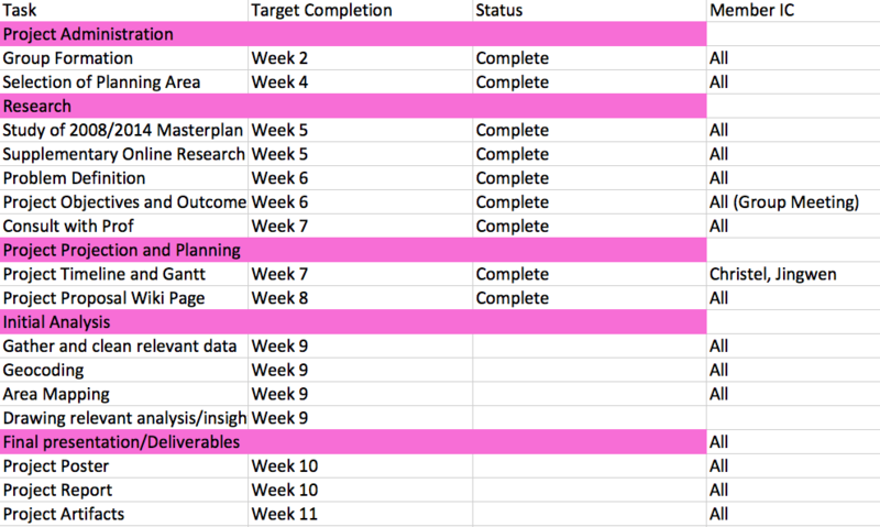
| − | [[File:Schedule1.png| | + | [[File:Schedule1.png|1300x350px|center]]<br><br> |
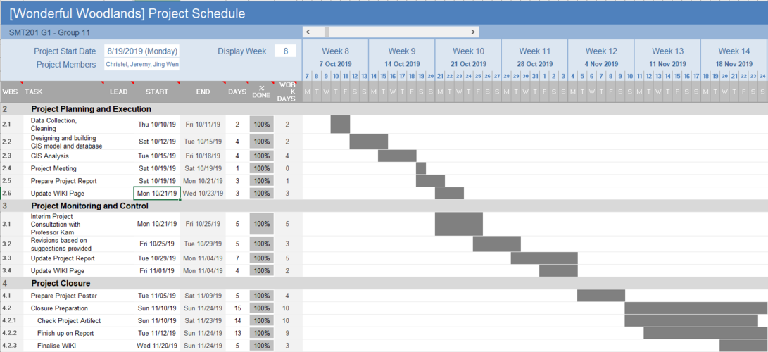
| + | [[File:Schedule2.png|3800x500px|center]] | ||
---- | ---- | ||
|} | |} | ||
Latest revision as of 18:00, 26 November 2019
| HOME | PROPOSAL | POSTER | WEB MAPS | RESEARCH PAPER |
Contents
Project Motivation
|
With a size of 724 square kilometers, half that of London, Singapore is a city state with limited land space. As such, careful and stringent planning is needed to make the best use of current available planning areas. The Singapore population is forecasted to grow to 6.52 million in 2035. We must now ask if current infrastructure and facilities can support this increase in population which would exert pressures on homes, amenities and public spaces.
|
|---|
Why Ang Mo Kio?
|
Ang Mo Kio is the 8th most populated planning area in the entire city state. Despite being a mature housing estate, one with more amenities and better accessibility, Ang Mo Kio still has immense potential for development. Situated in the North-East region of Singapore, Ang Mo Kio is home to an estimated 143,800 HDB residents, and has around 50,733 flats. Referring to and drawing valuable insights from the 2019 draft masterplan, we would then provide suggestions to better cater to the needs of the residents.
|
|---|
Project Objective
|
In this analysis, we compared the 2008 and 2014 URA Masterplan - with a vision of an inclusive, liveable and economically vibrant city state. Through this we identified changes in landuse and would be proceeding to project changes to the 2019 Masterplan.
|
|---|
Data
Scope of Work
|
|
|---|
Project Schedule
|
|
|---|


