Difference between revisions of "G2-Group01"
Jump to navigation
Jump to search
Jttan.2018 (talk | contribs) |
Jttan.2018 (talk | contribs) |
||
| (25 intermediate revisions by the same user not shown) | |||
| Line 1: | Line 1: | ||
| − | + | ||
| + | [[File:G2Grp1-header.jpg|1000px|center]] | ||
| + | |||
Group Members: | Group Members: | ||
| Line 5: | Line 7: | ||
* Lim Jia Yang James | * Lim Jia Yang James | ||
* Tan Jie Ting Christine | * Tan Jie Ting Christine | ||
| + | |||
| + | |||
| + | |||
| + | <div id="mw-content-text" lang="en-GB" dir="ltr" class="mw-content-ltr"><div class="mw-parser-output"><center> | ||
| + | <table style=""background-color:white;" width=""80%"|"> | ||
| + | |||
| + | <tr> | ||
| + | <td style="font-family:Open Sans, Arial, sans-serif; font-size:16px; text-align: center; border-top:solid #003366; border-bottom:solid #003366;" width="200px"> | ||
| + | <p><font color="#003366"><strong>Home</strong></font> | ||
| + | </p> | ||
| + | </td> | ||
| + | <td style="font-family:Open Sans, Arial, sans-serif; font-size:16px; text-align: center; border-top:solid #BBDEF0; border-bottom:solid #BBDEF0" width="200px"> | ||
| + | <p><strong>[[G2-Group01_Proposal|Proposal]]</strong> | ||
| + | </p> | ||
| + | </td> | ||
| + | <td style="font-family:Open Sans, Arial, sans-serif; font-size:16px; text-align: center; border-top:solid #BBDEF0; border-bottom:solid #BBDEF0" width="200px"> | ||
| + | <p><strong>[[G2-Group01_Poster|Poster]]</strong> | ||
| + | </p> | ||
| + | </td> | ||
| + | <td style="font-family:Open Sans, Arial, sans-serif; font-size:16px; text-align: center; border-top:solid #BBDEF0; border-bottom:solid #BBDEF0" width="200px"> | ||
| + | <p><strong>[[G2-Group01_WebMaps|Web Maps]]</strong> | ||
| + | </p> | ||
| + | </td> | ||
| + | <td style="font-family:Open Sans, Arial, sans-serif; font-size:16px; text-align: center; border-top:solid #BBDEF0; border-bottom:solid #BBDEF0" width="200px"> | ||
| + | <p><strong>[[G2-Group01_Report|Project Report]]</strong> | ||
| + | </p> | ||
| + | </td></tr> | ||
| + | |||
| + | </table> | ||
{| border="1" cellpadding="1" | {| border="1" cellpadding="1" | ||
| − | |- style="background-color:# | + | |- style="background-color:#003366; color: white; height:50px; text-align: center; margin: 0 auto" |
| − | ! style="width: | + | ! style="width:1600px"| Project Description |
| − | |||
| − | |||
| − | |||
|} | |} | ||
| + | |||
| + | <div style="text-align: left;"> | ||
| + | This project is a collaboration with an International Food Chain (IFC), where we study and strategically analyse the demographics of selected outlets within the Taoyuan region of Taiwan. Using the help of Geospatial Information Systems, namely QGIS, an open-source cross-platform geographic information system application, we aim to digitalise a map of the respective trade areas, and ultimately through our analysis to value-add to the IFC's business. | ||
| + | </div> | ||
| + | <br> | ||
| + | <br> | ||
| + | |||
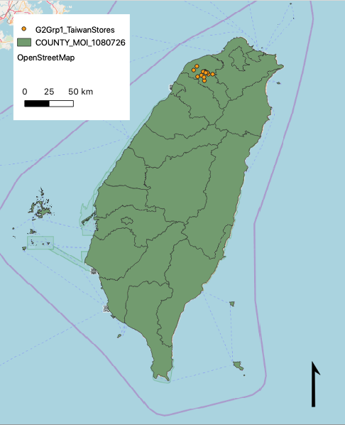
| + | [[File:G2Grp1 taiwanstoresV2.png|100px|center|frame|Area of Study, Taoyuan]] | ||
Latest revision as of 14:33, 17 October 2019
Group Members:
- Ho Wei Jie, Clint
- Lim Jia Yang James
- Tan Jie Ting Christine
|
Home |
| Project Description |
|---|
This project is a collaboration with an International Food Chain (IFC), where we study and strategically analyse the demographics of selected outlets within the Taoyuan region of Taiwan. Using the help of Geospatial Information Systems, namely QGIS, an open-source cross-platform geographic information system application, we aim to digitalise a map of the respective trade areas, and ultimately through our analysis to value-add to the IFC's business.

