G2-Group01 Proposal
|
Proposal |
| About Taoyuan |
|---|
Taoyuan is located approximately 40 km southwest of Taipei, in northern Taiwan, and occupies 1,220 km2. It is made up of low-lying plains, interconnected mountains and plateaus. Its shape has a long and narrow southeast-to-northwest trend, with the southeast in the Xueshan Range and the far end on the shores of the Taiwan Strait. As the location of Taiwan’s premier international airport, Taoyuan is not only the gateway to Taiwan, but also the first stop for international visitors arriving in our country, and an important hub for Taiwan’s interaction with the world. Taoyuan is one of Taiwan's top industrial and technology cities. Over 200 of Taiwan's top 500 manufacturing companies have factories in Taoyuan. Building on Taoyuan’s strategic location, excellent transportation links and rich industrial base, key industries targeted for development include aerospace maintenance and repair, warehousing and logistics, exhibitions and conventions, optoelectronics, green energy, value-added manufacturing, cloud computing, biotechnology and medicine. Through initiatives such as the Taoyuan Aerotropolis project, Taoyuan aims to reshape Taoyuan as a smart airport city. [1]
Artist's Impression of Taoyuan Aerotropolis Project [2]
| Project Motivation |
|---|
Big data is a term that describes the large volume of data – both structured and unstructured – that inundates a business on a day-to-day basis. Big data can be analyzed for insights that lead to better decisions and strategic business moves. [3] The use of Big Data is commonplace nowadays by companies to outperform their competitors. In most industries, existing competitors and new entrants alike will use the strategies resulting from the analyzed data to compete, innovate and capture value. With Big Data, the volume of data collected is not its selling point, but it is instead the information learned; and how it can be used to optimize business operations and make key strategic decisions. This project aims to digest a copious amount of data regarding various different points of interest (POI) and analyse its geographical relevance with our client's outlets.
Our project is a collaboration with an International Food Chain (IFC) with more than 16,000 outlets in over 100 countries with a staff team of around 300,000 members. For this project, we will narrow our scope to their Taiwan outlets, more specifically, 13 outlets in the region of Taoyuan. Utilizing geospatial analytics skills learnt in the classroom, we hope to discover meaningful relationships between the different POIs and the outlets.
| Project Objective |
|---|
This project aims to determine defining variables that enable certain stores to perform better than others. We hope to identify the factors of success through analysing the various POIs that are in the proximity of our designated trade areas. This is achieved through meeting the following objectives:
- Digitizing trade areas of our allocated stores
- Extracting relevant POIs within trade areas
- Making detailed business profiles of each outlet based on their respective POIs
| Project Data |
|---|
| Data Folder | Data Type | Data Source | Purpose |
|---|---|---|---|
| Admin Boundary • COUNTY_MOI_10 • TOWN_MOI_1080 • VILLAGE_MOI_121 |
Shapefile (.shp) | Client/Prof Kam | To outline the countys, towns and villages in Taiwan |
| GeoPackage • Taiwan_stores.gpkg |
GeoPackage (.gkpg) | Client | To locate our stores of study |
| location_map 1. Bade Qiao'ai |
Powerpoint (.pptx) | Client | To locate the area that surrounds our stores of study |
| POI (Points of Interest) 1. ATM |
Shapefile (.shp) | Prof Kam | To locate the point of interests within the marked out areas around our stores of study |
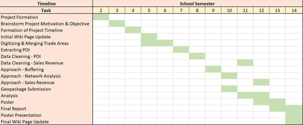
| Project Timeline |
|---|
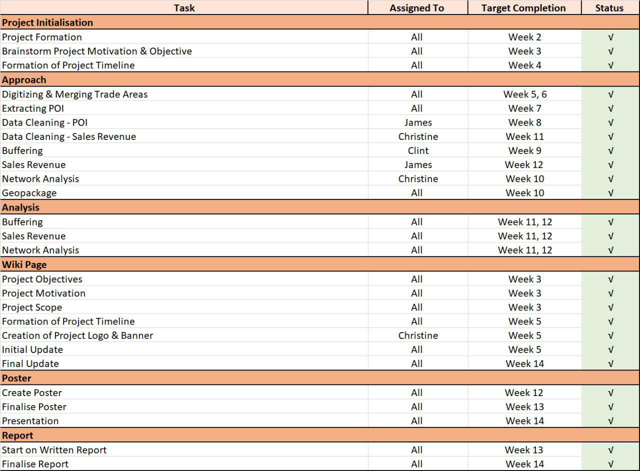
| Scope of Work |
|---|
References
[1] https://urdb.tycg.gov.tw/PLPR_TAOYUAN/web_page/PLPR010300.html
[2] DeAeth, Duncan. "Taiwan's Taoyuan Aerotropolis Project on track to begin in 2018", Taiwan News, Taiwan, 16 February 2018. Retrieved on 14 October 2019.
[3] SAS. "Big Data", SAS, USA, n.d. Retrieved on 17 October 2019.


