Difference between revisions of "SMT201 AY2019-20G1 EX2 Tan Kin Meng"
| Line 14: | Line 14: | ||
A short description of not more than 100 words for each view. | A short description of not more than 100 words for each view. | ||
| + | |||
| + | Each layer was created by extracting the respective features and clipping them with the Bukit Gombak study area. The Bukit Gombak study area was extracted from the Master Plan 2014 Subzone Boundary from URA found on Data.gov.sg [hhttps://data.gov.sg/dataset/master-plan-2014-subzone-boundary-no-sea[1<nowiki>]</nowiki>] | ||
=== Target roads === | === Target roads === | ||
| Line 25: | Line 27: | ||
=== Digital Elevation === | === Digital Elevation === | ||
| − | For the digital elevation layer, it was created by extracting the ASTER Global Digital Elevation Model (GDEM) dataset jointly prepared by NASA and METI, Japan according to the study area Bukit Gombak. After which, I used singleband grey for band rendering to show the elevation of Bukit Gombak. The map shows that the elevation increases gradually from north to the south of Bukit Gombak and peaks in Bukit Panjang camp as seen in the Open Street Map (OSM) | + | For the digital elevation layer, it was created by extracting the ASTER Global Digital Elevation Model (GDEM) dataset jointly prepared by NASA and METI, Japan according to the study area Bukit Gombak. After which, I used singleband grey for band rendering to show the elevation of Bukit Gombak. The map shows that the elevation increases gradually from north to the south of Bukit Gombak and peaks in Bukit Panjang camp as seen in the Open Street Map (OSM). |
| + | |||
| + | Data for the Digital Elevation Model was obtained from: [https://search.earthdata.nasa.gov/search?m=-7.175!25.59375!1!1!0!0%2C2[2<nowiki>]</nowiki>] and compiled by Professor Kam Tin Seong. | ||
== Proximity and slope == | == Proximity and slope == | ||
Revision as of 16:14, 10 November 2019
Contents
- 1 Objective: Identify a location suitable for building a national Communicable Disease Quarantine Centre in Bukit Gombak (Singapore)
- 2 Target roads, Buildings, Target Natural Features and Digital Elevation
- 3 Proximity and slope
- 4 A map layout with four views showing the criterion scores of each factor layers and a short description of not more than 150 words for each view
- 4.1 Economic factor: The selected site should avoid steep slope. This is because construction at steep slope tends to involve a lot of cut-and-fill and will lend to relatively higher development cost
- 4.2 Accessibility factor: The selected site should be close to existing local roads, namely: service roads and tracks. This is to ensure easy transportation of building materials during the construction stage
- 4.3 Health risk factor: The selected site should be away from population i.e. housing areas and offices in order to avoid disease spreading to the nearby population
- 4.4 Natural conservation factor: The selected site should be away from forested land, park and water
- 5 Analytical Hierarchical Process (AHP) analysis
- 6 Suitability land lot
Objective: Identify a location suitable for building a national Communicable Disease Quarantine Centre in Bukit Gombak (Singapore)
The selected site must be located at Gombak planning subzone, with a contiguous area of at least 10,000m2 and it must meet the following decision factors:
- Economic factor: The selected site should avoid steep slope. This is because construction at steep slope tends to involve a lot of cut-and-fill and will lend to relatively higher development cost.
- Accessibility factor: The selected site should be close to existing local roads, namely: service roads and tracks. This is to ensure easy transportation of building materials during the construction stage.
- Health risk factor: The selected site should be away from population i.e. housing areas and offices in order to avoid disease spreading to the nearby population.
- Natural conservation factor: The selected site should be away from forested land, park and water.
Target roads, Buildings, Target Natural Features and Digital Elevation
A short description of not more than 100 words for each view.
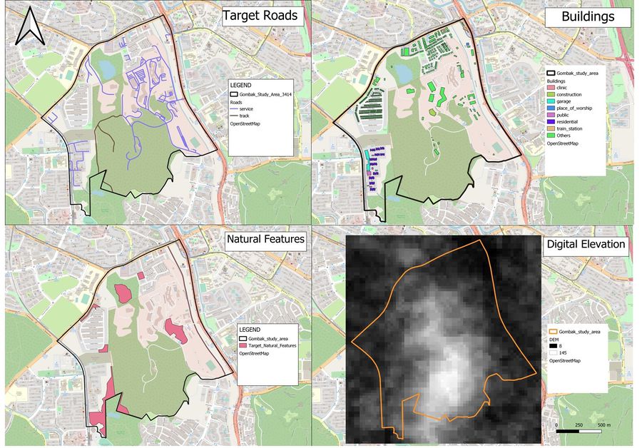
Each layer was created by extracting the respective features and clipping them with the Bukit Gombak study area. The Bukit Gombak study area was extracted from the Master Plan 2014 Subzone Boundary from URA found on Data.gov.sg [hhttps://data.gov.sg/dataset/master-plan-2014-subzone-boundary-no-sea[1]]
Target roads
For the target roads layer, we are tasked to analyse only service roads and track. Hence, I extracted the service and track layers and clip them with the Bukit Gombak study area, already extracted, to create the layer for target roads. As evident from the map, service road networks are more extensive in the North Eastern parts of Bukit Gombak.
Buildings
For the buildings layer, there are only a few types of buildings in the area and they are namely garage, construction sites, residential areas and public institutions. However, there are many buildings that are categorized under “Others” and by using the Open Street Map view, I can identify that some of these land uses are used by the military. This is relevant for the analysis later as we need to be aware that we might be building the quarantine area in the military camp.
Target Natural Features
For targeted natural features, I simply extracted the selected areas by clipping to the study area Bukit Gombak.
Digital Elevation
For the digital elevation layer, it was created by extracting the ASTER Global Digital Elevation Model (GDEM) dataset jointly prepared by NASA and METI, Japan according to the study area Bukit Gombak. After which, I used singleband grey for band rendering to show the elevation of Bukit Gombak. The map shows that the elevation increases gradually from north to the south of Bukit Gombak and peaks in Bukit Panjang camp as seen in the Open Street Map (OSM).
Data for the Digital Elevation Model was obtained from: [2] and compiled by Professor Kam Tin Seong.
Proximity and slope
A short description of not more than 150 words for each view.
Proximity to target roads layer
Description
Proximity to buildings layer
Description
Proximity to target natural features layer
Description
The study area and slope layer
Description
A map layout with four views showing the criterion scores of each factor layers and a short description of not more than 150 words for each view
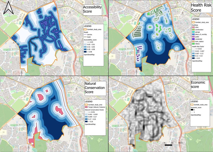
Economic factor: The selected site should avoid steep slope. This is because construction at steep slope tends to involve a lot of cut-and-fill and will lend to relatively higher development cost
Accessibility factor: The selected site should be close to existing local roads, namely: service roads and tracks. This is to ensure easy transportation of building materials during the construction stage
Health risk factor: The selected site should be away from population i.e. housing areas and offices in order to avoid disease spreading to the nearby population
Natural conservation factor: The selected site should be away from forested land, park and water
Analytical Hierarchical Process (AHP) analysis
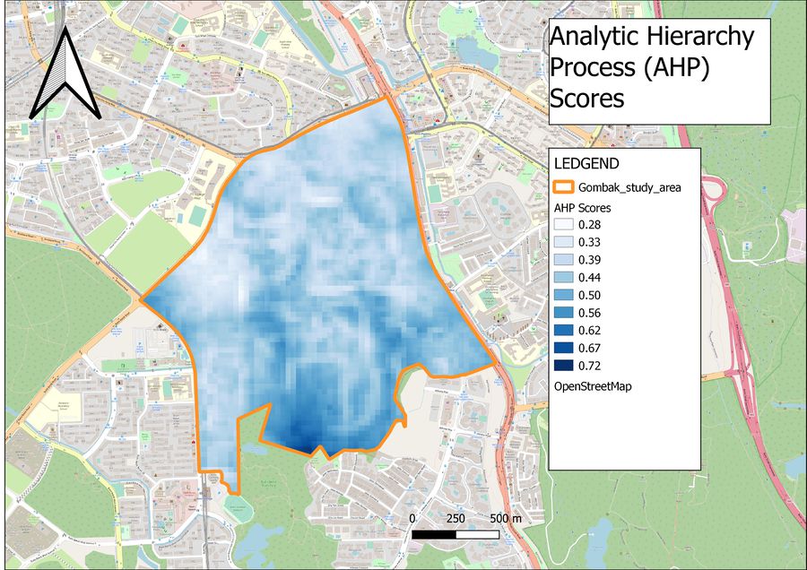
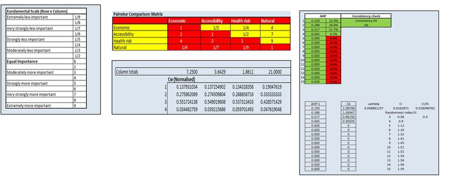
An Analytical Hierarchical Process input matrix and result report and a short description of not more than 150 words discussing the analysis results.
Analytical Hierarchical Process input matrix
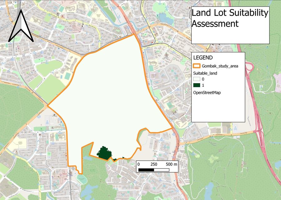
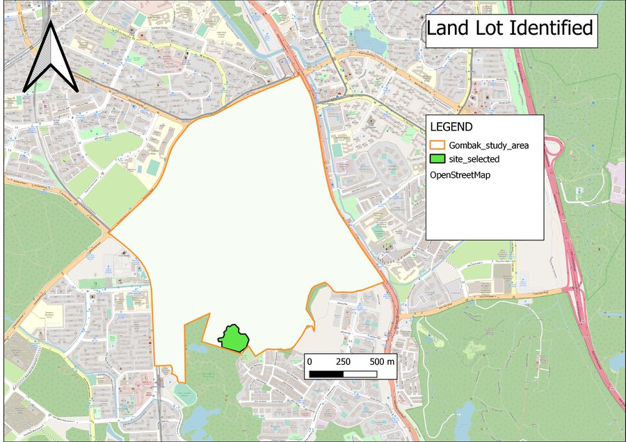
Suitability land lot
A map layout with the suitability land lot(s) and a short description of not more than 200 words commenting on each of the suitable land lot identified.
Land Lot Suitability Assessment
Area of land Identified
