Difference between revisions of "SMT201 AY2019-20T1 EX2 DionTeoMengEn"
| Line 35: | Line 35: | ||
The elevation of the land affects the economic factor when it comes to deciding a site for the construction of the National Communicable Diseases Quarantine Centre. Ideally, the selected site should avoid steep slopes to facilitate the construction process. A steep area will require a lot of cut-and-fill and result in higher development costs. | The elevation of the land affects the economic factor when it comes to deciding a site for the construction of the National Communicable Diseases Quarantine Centre. Ideally, the selected site should avoid steep slopes to facilitate the construction process. A steep area will require a lot of cut-and-fill and result in higher development costs. | ||
| − | As shown in the above map, the different intensity of blue suggests the steepness (i.e. | + | As shown in the above map, the different intensity of blue suggests the steepness (i.e. elevation) of the given area. The higher the intensity of blue, the higher the land is above sea level. With reference to the map, the elevation ranges from 8 to 145m above sea level, with the area of higher elevation lending towards the South of the study area. |
Revision as of 23:30, 9 November 2019
To build a National Communicable Disease Quarantine Centre, we need to identify a suitable plot of land that is of at least 10,000m3, the following decision factors are to be considered:
- Economic factor: The selected site should avoid steep slope. This is because construction at steep slope tends to involve a lot of cut-and-fill and will lend to relatively higher development cost.
- Accessibility factor: The selected site should be close to existing local roads, namely: service roads and tracks. This is to ensure easy transportation of building materials during the construction stage.
- Health risk factor: The selected site should be away from population i.e. housing areas and offices in order to avoid disease spreading to the nearby population.
- Natural conservation factor: The selected site should be away from forested land, park and water.
The following analysis will include discussions relating to:
- The respective target features (i.e. Roads, Buildings, Natural features, Elevation) present in the study area
- Proximity analysis of these target features
- An Analytical Hierarchical Process input Matrix and the relevant results
Combining all above discussions, a suitable land lot for the construction of the National Communicable Disease Quarantine Centre will then be suggested.
Target Features
Roads
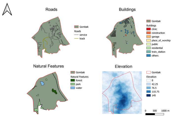
The target feature, Roads, reflects the level of accessibility in deciding the appropriate site for constructing the National Communicable Disease Quarantine Centre. The selected site should be close to existing roads so as to facilitate transportation of the necessary materials needed for construction. Particularly for this exercise, we are looking mainly at just roads for service and track, as we foresee that these are the roads that we predominantly need for the transportation of the building materials during the construction stage.
As shown in the above map, the 2 different types of road are classified and distinguished from the different colors used. There are a total of 199 service and 2 track roads serving the planning subzone of Gombak. These roads are rather well distributed across the study area of Gombak.
Buildings
The target feature, Buildings, reflects the level of Health Risks posed to the residents in the study area, Gombak. As quarantine center for communicable diseases, the selected site should, ideally, avoid and be far from buildings that house most of the population (i.e. housing or residential areas as well as offices). This is to prevent and lower the risks of such diseases spreading to the nearby population.
As shown in the above map, the different buildings that caters to the different needs of the population are classified and distinguished from the different colors used. These buildings are generally concentrated up North of the study area, Gombak, with the residential buildings focused in the general South-West of Gombak.
Natural Features
The target feature, Natural Features, reflects the factor of natural conservation when it comes to deciding and selecting a probable site for the construction of the National Communicable Diseases Quarantine Center. The selected site should, ideally, be away from forested land, parks and the water, such that we can conserve these areas and not have to demolish these areas to give way to the Center.
As shown in the above map, the different nature features are classified and distinguished from the different colors used. The colors were also selected such that users can intuitively recognize these areas (i.e. deep green for forests, plain green for parks and blue for water). These different features span across the study area, Gombak.
Elevation
The elevation of the land affects the economic factor when it comes to deciding a site for the construction of the National Communicable Diseases Quarantine Centre. Ideally, the selected site should avoid steep slopes to facilitate the construction process. A steep area will require a lot of cut-and-fill and result in higher development costs.
As shown in the above map, the different intensity of blue suggests the steepness (i.e. elevation) of the given area. The higher the intensity of blue, the higher the land is above sea level. With reference to the map, the elevation ranges from 8 to 145m above sea level, with the area of higher elevation lending towards the South of the study area.
