Difference between revisions of "SMT201 AY2019-20G1 Ex2 Luo Haonan"
(Created page with "== Part One - A Map Layout with Four Views showing Roads, Buildings, Natural Areas and Elevation == == Part Two - A Map Layout with Four Views showing Proximity Raster with R...") |
|||
| Line 1: | Line 1: | ||
== Part One - A Map Layout with Four Views showing Roads, Buildings, Natural Areas and Elevation == | == Part One - A Map Layout with Four Views showing Roads, Buildings, Natural Areas and Elevation == | ||
| + | [[File:Map1 haonan v3.png]] | ||
| + | |||
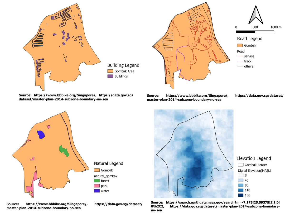
| + | === Map View(Buildings) === | ||
| + | Since the selected site should be away from the population, the suitable lot will probably be situated at the southern part of Gomabk by looking at the building layout alone, | ||
| + | |||
| + | === Map View(Roads) === | ||
| + | Since the project specification stated that the selected site should be close to local roads such as service and tracks. I have labeled other types of roads such as primary and secondary roads in black, they will not be used in the suitability analysis later. For service and tracks types of road, I am using red to represent in red and purple respectively. | ||
| + | |||
| + | === Map View(Natural) === | ||
| + | The natural features are located around the northern, eastern and western parts of Gombak. The forest areas are represented in green, the park is represented in pink and the water is represented in blue. By looking at the Natural feature alone, the suitability lots will probably be situated in the southern part of Gombak. | ||
| + | |||
| + | === Map View(Digital Elevation) === | ||
| + | In the digital elevation, darker color represents the highly elevated area, while the lighter color represents the low-lying area. The map shows that the southern part of Gombak is a highly elevated area which will incur more economic cost if the selected site is being built here. This also might be the reason why this area is not populated with buildings or roads. | ||
== Part Two - A Map Layout with Four Views showing Proximity Raster with Roads, Buildings, Natural Areas and Slope Raster layer == | == Part Two - A Map Layout with Four Views showing Proximity Raster with Roads, Buildings, Natural Areas and Slope Raster layer == | ||
Revision as of 16:38, 9 November 2019
Contents
- 1 Part One - A Map Layout with Four Views showing Roads, Buildings, Natural Areas and Elevation
- 2 Part Two - A Map Layout with Four Views showing Proximity Raster with Roads, Buildings, Natural Areas and Slope Raster layer
- 3 Part Three - A Map Layout with Four Views showing the Criterion Scores of Each Factor Layers
- 4 Part Four - An Analytical Hierarchical Process Input Matrix and Result Report
- 5 Part Five - Sutability Land Lots
Part One - A Map Layout with Four Views showing Roads, Buildings, Natural Areas and Elevation
Map View(Buildings)
Since the selected site should be away from the population, the suitable lot will probably be situated at the southern part of Gomabk by looking at the building layout alone,
Map View(Roads)
Since the project specification stated that the selected site should be close to local roads such as service and tracks. I have labeled other types of roads such as primary and secondary roads in black, they will not be used in the suitability analysis later. For service and tracks types of road, I am using red to represent in red and purple respectively.
Map View(Natural)
The natural features are located around the northern, eastern and western parts of Gombak. The forest areas are represented in green, the park is represented in pink and the water is represented in blue. By looking at the Natural feature alone, the suitability lots will probably be situated in the southern part of Gombak.
Map View(Digital Elevation)
In the digital elevation, darker color represents the highly elevated area, while the lighter color represents the low-lying area. The map shows that the southern part of Gombak is a highly elevated area which will incur more economic cost if the selected site is being built here. This also might be the reason why this area is not populated with buildings or roads.
