Difference between revisions of "G1-Group08 Project Web Maps"
Jump to navigation
Jump to search

| (4 intermediate revisions by 2 users not shown) | |||
| Line 22: | Line 22: | ||
<!------- End of Main Navigation Bar----> | <!------- End of Main Navigation Bar----> | ||
<br> | <br> | ||
| − | |||
| − | < | + | <div style="text-align: center;width: 95%;"><font size=3px; face="Open Sans, Arial, sans-serif">Click on the image below to view our <b>web maps</b> for our project.</font></div><br> |
| + | [[File: SMT201 G1-Group08 Web Maps.png|center|300px|link=https://qgiscloud.com/eddieleow/g1t8]] | ||
<div style="padding: 15px; line-height: 1em; border-bottom: #789DBF solid 2px;font-size: 20px; width=90%;"></div> | <div style="padding: 15px; line-height: 1em; border-bottom: #789DBF solid 2px;font-size: 20px; width=90%;"></div> | ||
| Line 30: | Line 30: | ||
<div style="text-align: left; padding: 15px; line-height: 1em; border-left: #789DBF solid 8px;font-size: 20px; width: 95%;"><font color=#385380">How to navigate the Web Maps</font></div> | <div style="text-align: left; padding: 15px; line-height: 1em; border-left: #789DBF solid 8px;font-size: 20px; width: 95%;"><font color=#385380">How to navigate the Web Maps</font></div> | ||
<br> | <br> | ||
| − | <div style="width: 95%;"><font size=3px; face="Open Sans, Arial, sans-serif">1. Access | + | <div style="width: 95%;"><font size=3px; face="Open Sans, Arial, sans-serif">1. Access our web maps through [http://qgiscloud.com/eddieleow/g1t8 qgiscloud.com/eddieleow/g1t8] <b><u>or</u></b> click on the above image which will direct you to the <b>home page</b> as shown below.</font></div> |
<br> | <br> | ||
[[File:G1T8 qgiscloud 1.png||center|800px]] | [[File:G1T8 qgiscloud 1.png||center|800px]] | ||
<br> | <br> | ||
| − | <div style="width: 95%;"><font size=3px; face="Open Sans, Arial, sans-serif">2. On the top right hand corner, there is a Map & Tools menu bar which has 3 options to choose from: | + | <div style="width: 95%;"><font size=3px; face="Open Sans, Arial, sans-serif">2. On the top right hand corner, there is a <b>Map & Tools</b> menu bar which has 3 options to choose from: |
* Layers & Legend | * Layers & Legend | ||
* Map Tools | * Map Tools | ||
* Print | * Print | ||
</font></div> | </font></div> | ||
| − | |||
[[File:G1T8 qgiscloud 2.png||left|240px]] | [[File:G1T8 qgiscloud 2.png||left|240px]] | ||
<br><br><br><br><br><br><br> | <br><br><br><br><br><br><br> | ||
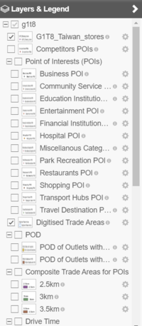
<div style="width: 95%;"><font size=3px; face="Open Sans, Arial, sans-serif">3. Upon clicking on <b>Layers & Legend</b>, you can view all the main layers. | <div style="width: 95%;"><font size=3px; face="Open Sans, Arial, sans-serif">3. Upon clicking on <b>Layers & Legend</b>, you can view all the main layers. | ||
* To view certain layers on the map, check the box beside the layer and it will appear on the map. | * To view certain layers on the map, check the box beside the layer and it will appear on the map. | ||
| − | Note: Layers are arranged in an order where the top layer will be on top of the next layer. | + | <b><font color="red">Note</font>:</b> Layers are arranged in an order where the top layer will be on top of the next layer. |
</font></div> | </font></div> | ||
| − | |||
[[File:G1T8 qgiscloud 3.png||left|240px]] | [[File:G1T8 qgiscloud 3.png||left|240px]] | ||
| − | + | <br><br><br><br><br><br><br><br><br><br><br><br><br> | |
<div style="width: 95%;"><font size=3px; face="Open Sans, Arial, sans-serif">4. To view the sub layers, click on the + sign to expand the main layer.</font></div> | <div style="width: 95%;"><font size=3px; face="Open Sans, Arial, sans-serif">4. To view the sub layers, click on the + sign to expand the main layer.</font></div> | ||
| − | |||
[[File:G1T8 qgiscloud 4.png||left|200px]] | [[File:G1T8 qgiscloud 4.png||left|200px]] | ||
<br><br><br><br><br><br><br><br><br><br><br><br><br><br><br><br><br><br><br><br><br> | <br><br><br><br><br><br><br><br><br><br><br><br><br><br><br><br><br><br><br><br><br> | ||
<div style="width: 95%;"><font size=3px; face="Open Sans, Arial, sans-serif">5. QGIS Cloud also comes with Map Tools to further enhance user experience. Click on <b>Map Tools</b> then <b>Measure</b> option will appear.</font></div> | <div style="width: 95%;"><font size=3px; face="Open Sans, Arial, sans-serif">5. QGIS Cloud also comes with Map Tools to further enhance user experience. Click on <b>Map Tools</b> then <b>Measure</b> option will appear.</font></div> | ||
| − | |||
[[File:G1T8 qgiscloud 6.png||left|240px]] | [[File:G1T8 qgiscloud 6.png||left|240px]] | ||
<br><br><br><br><br><br><br><br> | <br><br><br><br><br><br><br><br> | ||
| − | <div style="width: 95%;"><font size=3px; face="Open Sans, Arial, sans-serif">6. Upon clicking on <b>Measure</b>, a pop-up box with 4 options will appear. The options available are | + | <div style="width: 95%;"><font size=3px; face="Open Sans, Arial, sans-serif">6. Upon clicking on <b>Measure</b>, a pop-up box with 4 options will appear. The options available are: |
* Position | * Position | ||
* Length | * Length | ||
| Line 63: | Line 59: | ||
* Bearing | * Bearing | ||
</font></div> | </font></div> | ||
| − | |||
[[File:G1T8 qgiscloud 7.png||left|240px]] | [[File:G1T8 qgiscloud 7.png||left|240px]] | ||
<br><br><br> | <br><br><br> | ||
<div style="width: 95%;"><font size=3px; face="Open Sans, Arial, sans-serif">7. <b>Position</b><br> | <div style="width: 95%;"><font size=3px; face="Open Sans, Arial, sans-serif">7. <b>Position</b><br> | ||
As per stated in the title, position allows you to find the coordinates of a point in the map. To use position, simply just click on anywhere in the map and the coordinates (e.g. 190468 2634827) will appear on the white bar. Copy and paste the coordinates to the search bar to return you the point in the map.</font></div> | As per stated in the title, position allows you to find the coordinates of a point in the map. To use position, simply just click on anywhere in the map and the coordinates (e.g. 190468 2634827) will appear on the white bar. Copy and paste the coordinates to the search bar to return you the point in the map.</font></div> | ||
| − | |||
[[File:G1T8 qgiscloud 8.png||left|240px]] | [[File:G1T8 qgiscloud 8.png||left|240px]] | ||
| − | + | <br><br><br><br><br><br><br><br><br> | |
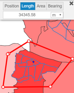
<div style="width: 95%;"><font size=3px; face="Open Sans, Arial, sans-serif">8. <b>Length</b><br> | <div style="width: 95%;"><font size=3px; face="Open Sans, Arial, sans-serif">8. <b>Length</b><br> | ||
As per stated in the title, length allows you to measure the distance between the starting point and ending point on the map. You can start the measurement by clicking a point on the map and end the measure by double clicking a point on the map. | As per stated in the title, length allows you to measure the distance between the starting point and ending point on the map. You can start the measurement by clicking a point on the map and end the measure by double clicking a point on the map. | ||
* There are 4 units of measurement available - m, ft, km and mi. | * There are 4 units of measurement available - m, ft, km and mi. | ||
</font></div> | </font></div> | ||
| − | |||
[[File:G1T8 qgiscloud 9.png||left|240px]] | [[File:G1T8 qgiscloud 9.png||left|240px]] | ||
| − | + | <br><br><br><br><br><br><br><br><br><br><br><br><br><br> | |
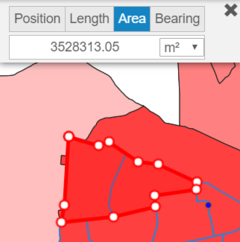
<div style="width: 95%;"><font size=3px; face="Open Sans, Arial, sans-serif">9. <b>Area</b><br> | <div style="width: 95%;"><font size=3px; face="Open Sans, Arial, sans-serif">9. <b>Area</b><br> | ||
As per stated in the title, area allows you to measure the area by plotting a polygon on the map. To form a polygon, start by clicking a point on the map and when you are done, click on the starting point of the polygon. | As per stated in the title, area allows you to measure the area by plotting a polygon on the map. To form a polygon, start by clicking a point on the map and when you are done, click on the starting point of the polygon. | ||
* There are 4 units of measurement available - m<sup>2</sup>, ft<sup>2</sup>, km<sup>2</sup>, mi<sup>2</sup>. | * There are 4 units of measurement available - m<sup>2</sup>, ft<sup>2</sup>, km<sup>2</sup>, mi<sup>2</sup>. | ||
</font></div> | </font></div> | ||
| − | |||
[[File:G1T8 qgiscloud 10.png||left|240px]] | [[File:G1T8 qgiscloud 10.png||left|240px]] | ||
<br><br><br><br><br><br><br><br><br><br><br> | <br><br><br><br><br><br><br><br><br><br><br> | ||
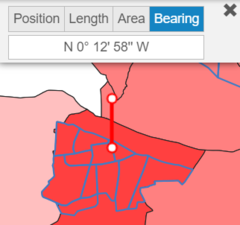
<div style="width: 95%;"><font size=3px; face="Open Sans, Arial, sans-serif">10. <b>Bearing</b><br> | <div style="width: 95%;"><font size=3px; face="Open Sans, Arial, sans-serif">10. <b>Bearing</b><br> | ||
As per stated in the title, bearing allows you to find the bearings relative to the point on the map.</font></div> | As per stated in the title, bearing allows you to find the bearings relative to the point on the map.</font></div> | ||
| − | |||
[[File:G1T8 qgiscloud 11.png||left|240px]] | [[File:G1T8 qgiscloud 11.png||left|240px]] | ||
<br><br><br><br><br><br><br><br><br><br><br> | <br><br><br><br><br><br><br><br><br><br><br> | ||
| Line 96: | Line 87: | ||
* Zoom out represented by '-' is to zoom out of the map | * Zoom out represented by '-' is to zoom out of the map | ||
</font></div> | </font></div> | ||
| − | |||
[[File:G1T8 qgiscloud 12.png||left|50px]] | [[File:G1T8 qgiscloud 12.png||left|50px]] | ||
<br><br><br><br><br><br><br><br><br><br> | <br><br><br><br><br><br><br><br><br><br> | ||
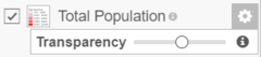
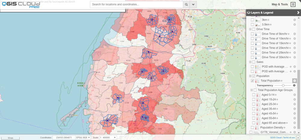
<div style="width: 95%;"><font size=3px; face="Open Sans, Arial, sans-serif">12. You may adjust the transparency of each layer or sub layer | <div style="width: 95%;"><font size=3px; face="Open Sans, Arial, sans-serif">12. You may adjust the transparency of each layer or sub layer | ||
by clicking on the setting icon right beside the layer name and slide the slider to adjust the transparency.</font></div> | by clicking on the setting icon right beside the layer name and slide the slider to adjust the transparency.</font></div> | ||
| − | |||
[[File:G1T8 qgiscloud 13.png||left|240px]] | [[File:G1T8 qgiscloud 13.png||left|240px]] | ||
| − | + | <br><br><br> | |
<div style="width: 95%;"><font size=3px; face="Open Sans, Arial, sans-serif"> | <div style="width: 95%;"><font size=3px; face="Open Sans, Arial, sans-serif"> | ||
| − | * Drag the circle on the transparency bar towards the right to reduce the transparency</font></div | + | * Drag the circle on the transparency bar towards the right to reduce the transparency.</font></div> |
| − | |||
[[File:G1T8 qgiscloud 14.png||center|1000px]] | [[File:G1T8 qgiscloud 14.png||center|1000px]] | ||
<br> | <br> | ||
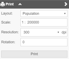
| Line 112: | Line 100: | ||
* There are 4 options to adjust the map printing - layout, scale, resolution and rotation. | * There are 4 options to adjust the map printing - layout, scale, resolution and rotation. | ||
</font></div> | </font></div> | ||
| − | |||
[[File:G1T8 qgiscloud 15.png||left|240px]] | [[File:G1T8 qgiscloud 15.png||left|240px]] | ||
<br><br><br><br><br><br><br><br><br><br> | <br><br><br><br><br><br><br><br><br><br> | ||
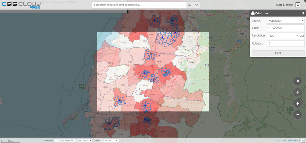
<div style="width: 95%;"><font size=3px; face="Open Sans, Arial, sans-serif"> | <div style="width: 95%;"><font size=3px; face="Open Sans, Arial, sans-serif"> | ||
| − | It will also show the area of which layer should you want to print the map.</font></div> | + | It will also show the area of which layer should you want to print the map.</font></div><br> |
| − | <br> | ||
[[File:G1T8 qgiscloud 16.png||center|1000px]] | [[File:G1T8 qgiscloud 16.png||center|1000px]] | ||
| − | |||
| − | |||
| − | |||
Latest revision as of 21:39, 24 November 2019
Click on the image below to view our web maps for our project.
How to navigate the Web Maps
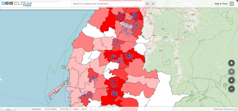
1. Access our web maps through qgiscloud.com/eddieleow/g1t8 or click on the above image which will direct you to the home page as shown below.

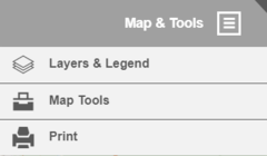
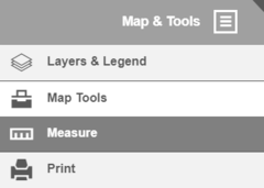
2. On the top right hand corner, there is a Map & Tools menu bar which has 3 options to choose from:
- Layers & Legend
- Map Tools

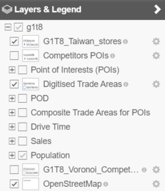
3. Upon clicking on Layers & Legend, you can view all the main layers.
- To view certain layers on the map, check the box beside the layer and it will appear on the map.
Note: Layers are arranged in an order where the top layer will be on top of the next layer.

4. To view the sub layers, click on the + sign to expand the main layer.

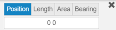
5. QGIS Cloud also comes with Map Tools to further enhance user experience. Click on Map Tools then Measure option will appear.

6. Upon clicking on Measure, a pop-up box with 4 options will appear. The options available are:
- Position
- Length
- Area
- Bearing

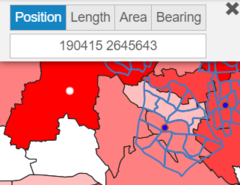
7. Position
As per stated in the title, position allows you to find the coordinates of a point in the map. To use position, simply just click on anywhere in the map and the coordinates (e.g. 190468 2634827) will appear on the white bar. Copy and paste the coordinates to the search bar to return you the point in the map.
As per stated in the title, position allows you to find the coordinates of a point in the map. To use position, simply just click on anywhere in the map and the coordinates (e.g. 190468 2634827) will appear on the white bar. Copy and paste the coordinates to the search bar to return you the point in the map.

8. Length
As per stated in the title, length allows you to measure the distance between the starting point and ending point on the map. You can start the measurement by clicking a point on the map and end the measure by double clicking a point on the map.
- There are 4 units of measurement available - m, ft, km and mi.

9. Area
As per stated in the title, area allows you to measure the area by plotting a polygon on the map. To form a polygon, start by clicking a point on the map and when you are done, click on the starting point of the polygon.
- There are 4 units of measurement available - m2, ft2, km2, mi2.

10. Bearing
As per stated in the title, bearing allows you to find the bearings relative to the point on the map.
As per stated in the title, bearing allows you to find the bearings relative to the point on the map.

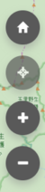
11. There are 4 buttons available on the lower right side of the map for user to navigate around the map.
- Home represented by home icon is to return to home page
- Navigation represented by navigation icon and is currently unavailable
- Zoom in represented by '+' is to zoom in to the map
- Zoom out represented by '-' is to zoom out of the map

12. You may adjust the transparency of each layer or sub layer
by clicking on the setting icon right beside the layer name and slide the slider to adjust the transparency.

- Drag the circle on the transparency bar towards the right to reduce the transparency.

13. You can also print the map in hard copy to reference.
- There are 4 options to adjust the map printing - layout, scale, resolution and rotation.

It will also show the area of which layer should you want to print the map.
