Difference between revisions of "Jingyi Proximity"
| Line 28: | Line 28: | ||
|} </div></br> | |} </div></br> | ||
<!--/Header--> | <!--/Header--> | ||
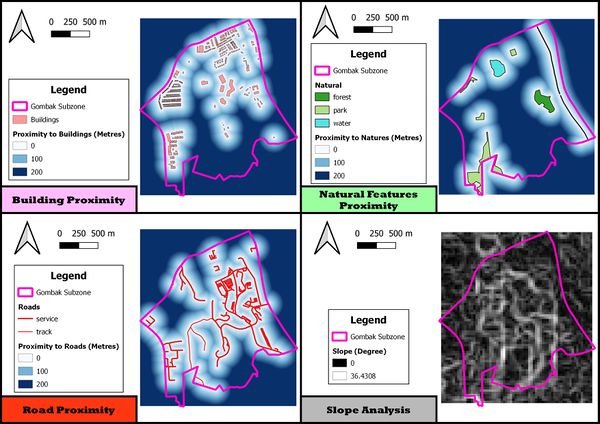
| − | + | To select a suitable site, a proximity analysis is needed to analyze the distance the potential sites is from the factors as well as the steepness of the potential sites in Gombak. | |
| − | [[File:Proxi4.jpg| | + | [[File:Proxi4.jpg|600px|frameless|center]] |
</br> | </br> | ||
| Line 35: | Line 35: | ||
</br> | </br> | ||
| − | + | A darker blue indicate a further distance the potential sites is from the buildings as compared to lighter blue. This means that potential sites that are depicted in darker blue will translates to a higher suitability in term of the health risks factor. The range of distance is capped at 200 metres as sites 200 metres away from the buildings is considered safe for the population living there if a quarantine centre is built. | |
<div class="Frame" style="{{Round corners}}; background: #50C878; text-align: center; padding: 0px; font-size: 200%;"><font face="arial" color="#ffffff " size="+1"><b>Proximity to Natural Features</b></font></div></div> | <div class="Frame" style="{{Round corners}}; background: #50C878; text-align: center; padding: 0px; font-size: 200%;"><font face="arial" color="#ffffff " size="+1"><b>Proximity to Natural Features</b></font></div></div> | ||
</br> | </br> | ||
| − | + | Similar to proximity to buildings, a darker blue indicates a further distance the potential sites is from the natural features as compared to lighter shade of blue. This also mean that a potential sites that are depicted in darker blue will translates to a higher suitability to build a quarantine centre in term of the natural conservation factors. | |
| − | |||
<div class="Frame" style="{{Round corners}}; background: #ED4337; text-align: center; padding: 0px; font-size: 200%;"><font face="arial" color="#ffffff " size="+1"><b>Proximity to Roads</b></font></div></div> | <div class="Frame" style="{{Round corners}}; background: #ED4337; text-align: center; padding: 0px; font-size: 200%;"><font face="arial" color="#ffffff " size="+1"><b>Proximity to Roads</b></font></div></div> | ||
</br> | </br> | ||
| − | + | In the case of proximity to roads, a potential sites that are depicted in darker blue will translates to a lower suitability to build a quarantine centre in term of the accessibility factor and a lighter blue will translates to a higher suitability to build a quarantine centre. | |
<div class="Frame" style="{{Round corners}}; background: #808080; text-align: center; padding: 0px; font-size: 200%;"><font face="arial" color="#ffffff " size="+1"><b>Slope Analysis</b></font></div></div> | <div class="Frame" style="{{Round corners}}; background: #808080; text-align: center; padding: 0px; font-size: 200%;"><font face="arial" color="#ffffff " size="+1"><b>Slope Analysis</b></font></div></div> | ||
</br> | </br> | ||
| − | + | Potential sites that are of lighter shades are more steep and is deemed less suitable to be selected as the site for construction of the quarantine centre in term of the economic factors. The minimum steepness of the land in Gombak is at 0 degree and the maximum steepness of the land in Gombak is at approximate 37 degree. | |
Revision as of 23:01, 10 November 2019
To select a suitable site, a proximity analysis is needed to analyze the distance the potential sites is from the factors as well as the steepness of the potential sites in Gombak.
A darker blue indicate a further distance the potential sites is from the buildings as compared to lighter blue. This means that potential sites that are depicted in darker blue will translates to a higher suitability in term of the health risks factor. The range of distance is capped at 200 metres as sites 200 metres away from the buildings is considered safe for the population living there if a quarantine centre is built.
Similar to proximity to buildings, a darker blue indicates a further distance the potential sites is from the natural features as compared to lighter shade of blue. This also mean that a potential sites that are depicted in darker blue will translates to a higher suitability to build a quarantine centre in term of the natural conservation factors.
In the case of proximity to roads, a potential sites that are depicted in darker blue will translates to a lower suitability to build a quarantine centre in term of the accessibility factor and a lighter blue will translates to a higher suitability to build a quarantine centre.
Potential sites that are of lighter shades are more steep and is deemed less suitable to be selected as the site for construction of the quarantine centre in term of the economic factors. The minimum steepness of the land in Gombak is at 0 degree and the maximum steepness of the land in Gombak is at approximate 37 degree.
