Issho-ni Proposal

From Geospatial Analytics for Urban Planning
Jump to navigation Jump to search
Home Page


HOME

PROPOSAL

POSTER

REPORT PAPER


Project Proposal


Project Motivation

Yishun overall appears to be well-equipped with plenty of schools, accommodation, parks, transportations, sport facilities, entertainment and medical facilities. Yet, the place remains to be one of the most dangerous residential areas to live in and has the highest crime rate in Singapore. Although there has been a decreasing trend in the young (aged between 10 – 25) population in Yishun, the elderly (aged 65 & above) population has increased for about 52% from 2010 to 2015. Furthermore, despite the increasing number of elderly populations in Yishun, the number of elderly care centres in the region seems to be highly lacking.

The motivation of this project is to use Geospatial information and technology in urban planning to provide useful insights that will ensure the safety and well-being of the residents, especially the elderly groups, of Yishun.

Project Objective & Scope

With the growing aging population and decreasing young population of Yishun, it is important to make use of the Geospatial information and technology in order to address some of the social problems and to ensure appropriate urban planning implementations in Yishun.

By making use of our own research and data extracted from various government sources such as Singstat and Data.gov, we aim to provide insights and analysis of Yishun planning area in terms of the followings:

  1. Population changes across all age groups
  2. Employment trends of Yishun residents
  3. Changes in the landscapes of Yishun and their purposes
  4. Recommendations on Yishun’s future urban planning

Data

Data Name Graphic Representation Format Source
Landuse
Planning Area Polygon Shapefile https://data.gov.sg/dataset/master-plan-2014-planning-area-boundary-no-sea
Master Plan 2008 Land Use Polygon Shapefile https://data.gov.sg/dataset/master-plan-2014-land-use?resource_id=0d1a6cda-7cad-4b17-b9a8-9e173afebbc1
Master Plan 2014 Land Use Polygon Shapefile https://data.gov.sg/dataset/master-plan-2014-land-use?resource_id=0d1a6cda-7cad-4b17-b9a8-9e173afebbc1
Master Plan 2014 Buildings Polygon Shapefile https://data.gov.sg/dataset/master-plan-2014-building?resource_id=c0ff19d3-5c25-4b7d-8034-e8f6dc65d75f
Road Section Line Polyline Shapefile https://www.mytransport.sg/content/dam/datamall/datasets/Geospatial/RoadSectionLine.zip
Housing
HDB Property Point CSV https://data.gov.sg/dataset/hdb-property-information
SLA Dwelling Info Point Keyhole Markup Language (KML) https://data.gov.sg/dataset/sla-dwelling-information
Landed Housing Area Polygon Shapefile https://data.gov.sg/dataset/sdcp-landed-housing-area
Transport
Bus Stop Location Point Shapefile https://www.mytransport.sg/content/dam/datamall/datasets/Geospatial/BusStopLocation.zip
Train Station Point Shapefile https://www.mytransport.sg/content/dam/datamall/datasets/Geospatial/TrainStation.zip
Demographics
Singapore Residents by Subzone, Age Group and Sex Polygon Keyhole Markup Language (KML) https://data.gov.sg/dataset/singapore-residents-by-subzone-age-group-and-sex-june-2016-gender
Educational Institutions
Pre-Schools Point Keyhole Markup Language (KML) https://data.gov.sg/dataset/pre-schools-location
Primary Schools, Secondary Schools and Junior Colleges Point CSV Dataset from Hands-On Ex 4
Private Education Institutions Point Shapefile https://data.gov.sg/dataset/private-education-institutions
Amenities
Supermarkets Point CSV https://data.gov.sg/dataset/list-of-supermarket-licences
Eldercare Services Point Shapefile https://data.gov.sg/dataset/eldercare-services
CHAS Clinics Point Keyhole Markup Language (KML) https://data.gov.sg/dataset/chas-clinics


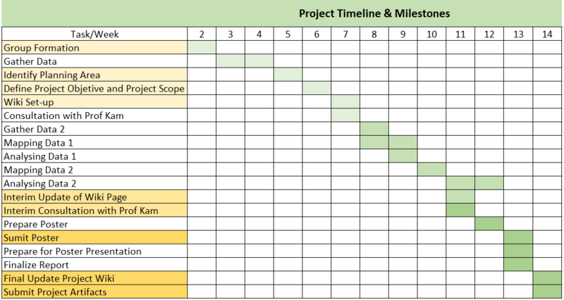
Project Schedule

G1 Group4 timeline.png