File:SchoolType.png
Jump to navigation
Jump to search


Size of this preview: 800 × 566 pixels. Other resolutions: 320 × 226 pixels | 3,507 × 2,480 pixels.
Original file (3,507 × 2,480 pixels, file size: 560 KB, MIME type: image/png)
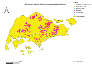
Categorized symbology was chosen in order to provide a visual representation of the different types of schools. The different school types are represented by a building icon of varying colors. The different colors provide a quick overview of the number of schools in each area. Based on the map, there is a high number of secondary and primary schools as compared to the rest.
File history
Click on a date/time to view the file as it appeared at that time.
| Date/Time | Thumbnail | Dimensions | User | Comment | |
|---|---|---|---|---|---|
| current | 14:43, 15 September 2019 | | 3,507 × 2,480 (560 KB) | Brendan.ong.2018 (talk | contribs) |
- You cannot overwrite this file.
File usage
The following page links to this file: