File:Proportion2018(1).png
Jump to navigation
Jump to search


Size of this preview: 800 × 566 pixels. Other resolutions: 320 × 226 pixels | 3,507 × 2,480 pixels.
Original file (3,507 × 2,480 pixels, file size: 1.12 MB, MIME type: image/png)
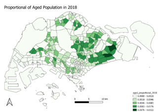
The proportion of aged population within each subzone to the total amount of population are derived from the division of aged population to the total amount of population.
File history
Click on a date/time to view the file as it appeared at that time.
| Date/Time | Thumbnail | Dimensions | User | Comment | |
|---|---|---|---|---|---|
| current | 22:42, 15 September 2019 | | 3,507 × 2,480 (1.12 MB) | Jingwen.tay.2018 (talk | contribs) |
- You cannot overwrite this file.
File usage
The following 2 pages link to this file:
.png&oldid=2946)
.png)
.png&action=edit&redlink=1)
.png&action=edit)
.png&action=history)
.png)
.png)
.png&printable=yes)
.png&oldid=2946)
.png&action=info)