ISSS608 2017-18 T3 Assign Gao Jiaoyang Conclusion
|
|
|
|
|
Contents
Conclusion
Question1
Characterize the past and most recent situation with respect to chemical contamination in the Boonsong Lekagul waterways. Do you see any trends of possible interest in this investigation? Your submission for this questions should contain no more than 10 images and 1000 words.
Question2
What anomalies do you find in the waterway samples dataset? How do these affect your analysis of potential problems to the environment? Is the Hydrology Department collecting sufficient data to understand the comprehensive situation across the Preserve? What changes would you propose to make in the sampling approach to best understand the situation? Your submission for this question should contain no more than 6 images and 500 words.
Data Issue
| Anomalies | Details |
|---|---|
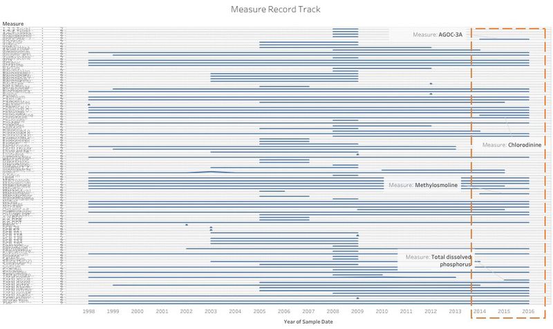
| Incomplete Data | Neither the test variables nor the date of the test seem to be random and chaotic. The date of the test is not continuous and there is no regularity, always suddenly record some measures and then stop without given any reasons. Apart from that, the test variables are not uniform, and most test data on test days are incomplete. Also, test times are rarely the same at different locations. All of these are likely to result in errors in subsequent data analysis. Because, if different test locations are compared with data from different test dates and variables, the results obtained are of little significance.
If we transform the raw dataset by split the measure into column, we can explore the missing pattern more directly. |
| Improper Timestamp | The raw dataset includes multiple records of the same measure in the same date at the same location with different values. This may due to the different test time in that day, if so, the timestamp should also include the precise time in that day instead of only the date. This issue may confuse investigators and also result in wrong conclusion. |
| Insufficient Data Source | If we want to detect the water pollution, we need more information to define the situation not just the timeline records. First, a large number of objective conditions may affect data measurements, which makes the data less "objective." Second, if we want to make sure that water pollution is related to he Kasios Furniture Company, we also need emissions data from Kasios. Third, a detailed data description will be more helpful. |
Proposal Change
| Proposal | Details |
|---|---|
| Regularise Record | The records should be regularised and unify to improve the quality of the data. Trying to unify the measure and date to improve the accuracy and the reliability of the research result |
| Supply Information |
|
Question3
After reviewing the data, do any of your findings cause particular concern for the Pipit or other wildlife? Would you suggest any changes in the sampling strategy to better understand the waterways situation in the Preserve? Your submission for this question should contain no more than 6 images and 500 words.
Finding
| Measure | Details |
|---|---|
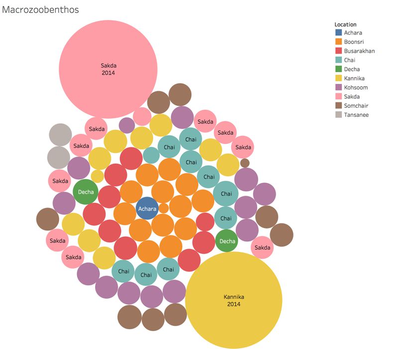
| Macrozootenthos | Benthic animals have a variety of ecological functions in the aquatic ecosystem. It can accelerate the decomposition of underwater debris to improve the self-purification of water bodies. It is also an important part of the nutrient niche of aquatic ecosystems. It is a natural live bait for fish. The material cycle and energy flow of aquatic ecosystems play an important role.Therefore, it has a good indication of environmental changes. The data shows macrozootenthos are relatively active at Sakda and Kannika in 2014. |
Suggestion
| Suggestion | Details |
|---|---|
| More information about the Pipit or other wildlife |
|
| More information about the location |
Currently, we only have a waterway map of the locations, we cannot do more exploration without more detail information. More precise data would help such as longitude and latitude. |
Reference
Page background picture.Cite error: Closing </ref> missing for <ref> tag
