Difference between revisions of "ISSS608 2016-17 T3 Assign ZHENG BIJUN"
| Line 94: | Line 94: | ||
<tr> | <tr> | ||
<td>[[File:ZBJ Activetime.jpg|600 px|left]]</td> | <td>[[File:ZBJ Activetime.jpg|600 px|left]]</td> | ||
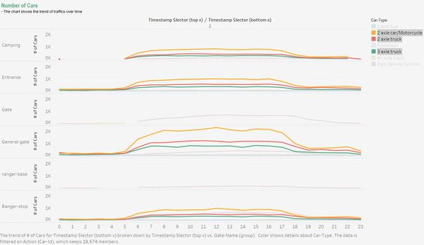
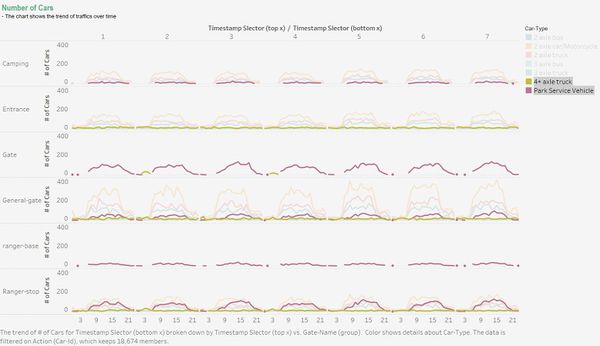
| − | <td>2 axle car/motorcycle, 2 axle truck, and 3 axle truck were most active vehicles in the preserve. Their activities started to increase at | + | <td>2 axle car/motorcycle, 2 axle truck, and 3 axle truck were most active vehicles in the preserve. Their activities started to increase at 6am and started to flatten out at around 18pm. 7am to 17pm had most vehicle activities. </td> |
</tr> | </tr> | ||
</table> | </table> | ||
Revision as of 17:07, 2 July 2017
Contents
VAST Challenge 2017: Mini-Challenge 1
Mistford is a mid-size city is located to the southwest of a large nature preserve. It has been discovered that the number of nesting pairs of the Rose-Crested Blue Pipit, a popular local bird due to its attractive plumage and pleasant songs, is decreasing! Provided several datasets, it is required to investigate the reason for the decrease of Rose-Crested Blue Pipit. In Mini-Challenge 1, traffic movement dataset is given to analyze patterns of life of vehicles through out the reserve, and detect unusual patterns that are potentially harmful to the birds. Questions raised are:
- Describe up to six daily patterns of life by vehicles traveling through and within the park.
- Describe up to six patterns of life that occur over multiple days (including across the entire data set) by vehicles traveling through and within the park.
- Describe up to six unusual patterns (either single day or multiple days) and highlight why you find them unusual.
- What are the top 3 patterns you discovered that you suspect could be most impactful to bird life in the nature preserve?
This webpage will guide you through my investigations and help to save Rose-Crested Blue Pipit!
Data Description
Entry gates are positioned at the Preserve entrances. Each vehicle receives an entry ticket at the gate and is assigned a vehicle class; the entry is recorded. The entry ticket contains an RF-tag that enables the Preserve sensors to pick up the passage of a vehicle through the Preserve. Each vehicle surrenders their entry ticket when exiting the Preserve and the exit is recorded. A .csv file containing data recorded from sensors around the Boonsong Lekagul Nature Preserve. A map containing the locations of roadways and sensors throughout the Preserve is also provided.
Dataset Overview
| 1 CSV Traffic Movement Data | 2 Roadway Map |
More Detailed Data Facts
1 CSV Traffic Movement Data
- Entrances:
- All vehicles pass through an Entrance when entering or leaving the Preserve.
- General-gates:
- All vehicles may pass through these gates. These sensors provide valuable information for the Preserve Rangers trying to understand the flow of traffic through the Preserve.
- Gates:
- These are gates that prevent general traffic from passing. Preserve Ranger vehicles have tags that allow them to pass through these gates to inspect or perform work on the roadway beyond.
- Ranger-stops:
- These sensors represent working areas for the Rangers, so you will often see a Ranger-stop sensor at the end of a road managed by a Gate. Some Ranger-stops are in other locations however, so these sensors record all traffic passing by.
- Camping:
- These sensors record visitors to the Preserve camping areas. Visitors pass by these entering and exiting a campground.
2 Roadway Map
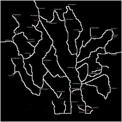
The contractors working with the Nature Preserve rangers have provided a map that presents the Preserve in terms of a 200x200 gridded area. The grid is oriented with north at the top of the map. Grid location (0,0) is at the lower left corner of the map (the SW corner). They have superimposed both the roadways and the sensor locations on this grid. The map shows an area 12 miles x 12 miles.
3 Others
- Traffic either passes through the Preserve, stay as day campers, or stay as extended campers.
- Preserve Rangers stay at the ranger-base toward the southeast of the Preserve when they are not working in the Preserve.
- The speed limit through the Preserve is 25 mph.
- The Preserve area does not observe "Daylight Savings Time".
- The roadways traveling southward from Entrances 3 and 4 do continue to other roadways outside of the Preserve area, but these are not shown on the map. Vehicle data will not reflect travel beyond the Preserve in this direction.
Data Preparation
Patterns of Life Analysis
Daily Patterns
| Images | Interpretations |
|---|---|
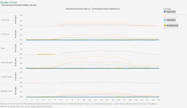
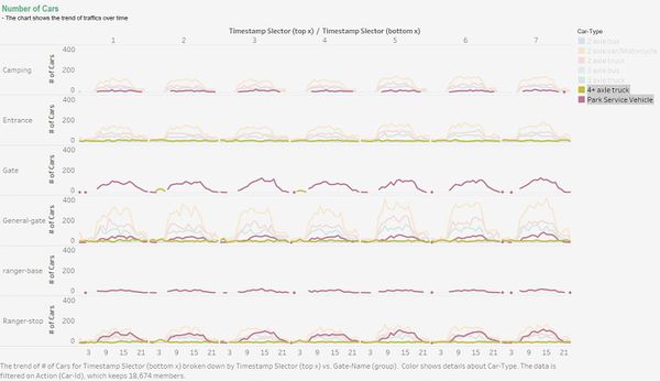
| Park service vehicles never showed up between 4am to 5am in any kind of gates. This might be the off-duty period of the rangers. | |
| The two types of buses and 4+ axle trucks, all large vehicles, had no appearance in any camping areas. It might represent that these three car-types can only be passing through the preserve, and camping area is not allowed for large vehicles. | |
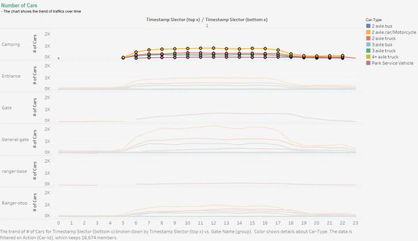
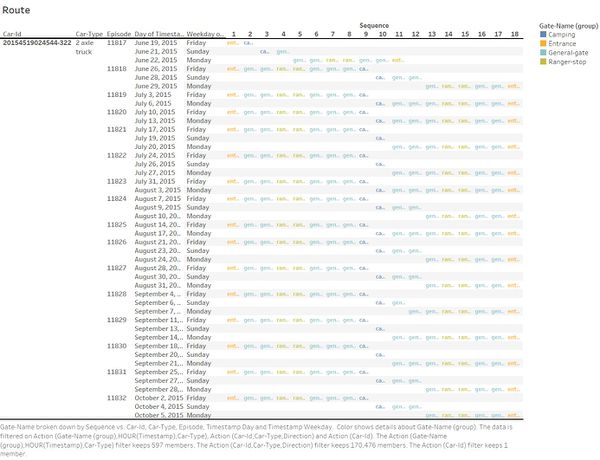
| Majority of traffics through camping areas only happened between 5am to 22pm, except for one car-id 20154519024544-322, which is discussed in later section. It might indicate that traffics were not allowed in camping areas after 22pm to ensure the safety and rest of overnight campers. | |
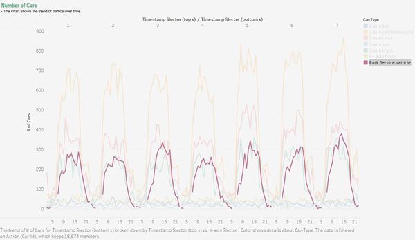
| 2 axle car/motorcycle, 2 axle truck, and 3 axle truck were most active vehicles in the preserve. Their activities started to increase at 6am and started to flatten out at around 18pm. 7am to 17pm had most vehicle activities. |
Longer-Period Patterns
| Images | Interpretations |
|---|---|
| Unauthorized 4+ axle truck appeared in gates only on Tuesday and Thursday, though not every week. | |
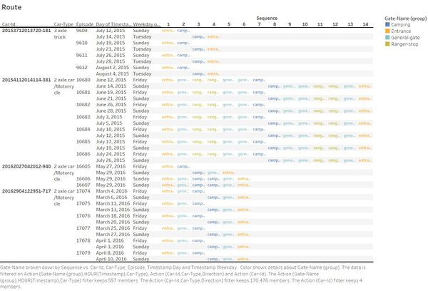
| Apart from car-id 20154519024544-322, there were another 4 car-ids that had multi-episodes. And every time they came to the preserve, they followed the same routes and went for overnight camping. |
Unusual Patterns
| Images | Interpretations |
|---|---|
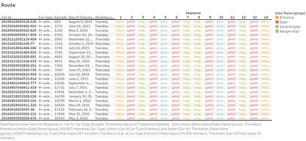
| This table displayed the route of car-id 20154519024544-322 (a 2 axle truck), which passed through camping gates after 22pm. This vehicle had 16 episodes, and each episode had exact same route except for the first episode. This vehicle came to the preserve each Friday and left the on the following Monday. | |
| The 4+ alxe trucks that passed through gates had different car-id but they all followed the exact same routes. | |
| More interestingly, apart from the fact that they only appeared on Tuesday and Thursday, the time they passed through gates could avoid the time when park service vehicles passed through those gates. |
