Difference between revisions of "Group02 proposal"
Lxguo.2017 (talk | contribs) |
Lxguo.2017 (talk | contribs) |
||
| Line 56: | Line 56: | ||
==<div style="background:#143c67; padding: 15px; font-weight: bold; line-height: 0.3em; letter-spacing:0.5em;font-size:20px"><font color=#fbfcfd face="Century Gothic"><center>DATASET</center></font></div>== | ==<div style="background:#143c67; padding: 15px; font-weight: bold; line-height: 0.3em; letter-spacing:0.5em;font-size:20px"><font color=#fbfcfd face="Century Gothic"><center>DATASET</center></font></div>== | ||
<center> | <center> | ||
| + | The Data Sets we will be using for our analysis and for our application is listed below: | ||
{| class="wikitable" width="100%" | {| class="wikitable" width="100%" | ||
|- | |- | ||
| Line 96: | Line 97: | ||
<center> | <center> | ||
<b>Commercial Data</b> | <b>Commercial Data</b> | ||
| − | (Jan 2012 - Dec 2019)<br/ | + | (Jan 2012 - Dec 2019)<br/> |
| − | |||
<br>Residential Data</b> | <br>Residential Data</b> | ||
(Jan 2012 - Dec 2019)<br/><br/> | (Jan 2012 - Dec 2019)<br/><br/> | ||
| + | (https://spring-ura-gov-sg.libproxy.smu.edu.sg/lad/ore/property_market/index.cfm)<br> | ||
</center> | </center> | ||
|| | || | ||
Revision as of 17:16, 29 February 2020
Contents
PROBLEM & MOTIVATION
Problem
When it comes to purchasing or renting a property, there are many factors that go into a buyer’s consideration before he makes the final decision. The primary concern for buyers is the pricing of the property [1]. However, our group identified that there are also secondary concerns such as the weather and the amenities available that do influence the buyer’s final decision to purchase the property. There are limited tools available to help property buyers to identify areas that suit their needs/preferences best. The current tools that are available are only optimal to suit one category of concern, but fails when we try to use more categories to make our visualization.
For example, different people have different preferences for the weather. Some may prefer sunny weather while others prefer it to rain all the time. Currently, we are able to find weather information, and property prices information, but not both at the same time.
Motivation
Through the visualization, our group hopes to be able to better allow for users to be able to visualize a home of his dreams beyond mere price.
OBJECTIVES
We aim to provide an interactive visualization dashboard to assist property seekers with identifying the housing area that best suits their needs with visualization information such as:
- Insights on the weather (which consists of the Rainfall Precipitation, Temperature and Wind speed) of each postal area.
- Insights on the available amenities within the proximity of the selected geo boundary.
- Insights on the distribution of commercial and residential prices for each postal area over the past few years.
Target Group:
- Property buyers with weather preferences
- Commerical buyers who wants to open a shop
DATASET
The Data Sets we will be using for our analysis and for our application is listed below:
| Data/Source | Variables/Description | Rationale Of Usage |
|---|---|---|
|
Temperature and Rainfall Data |
|
The dataset will be used to understand the Indonesian Export and import figure from 1996 - 2019, July across multiple categories. At the end, we wish to spot the trend or pattern of Indonesia trading and economy situation. |
|
Location Data |
|
The dataset will be used to understand the Indonesian Export and import figure from 1996 - 2019, July across multiple categories. At the end, we wish to spot the trend or pattern of Indonesia trading and economy situation. |
|
Commercial Data
(Jan 2012 - Dec 2019)
(https://spring-ura-gov-sg.libproxy.smu.edu.sg/lad/ore/property_market/index.cfm) |
|
go change |
BACKGROUND SURVEY OF RELATED WORK
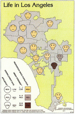
Below are a few visualizations and charts we considered making for our projects.
| Visual Considerations | Insights / Comments |
|---|---|
Title: Qualitative Thematic Map Source: https://mapdesign.icaci.org/2014/12/mapcarte-353365-life-in-los-angeles-by-eugene-turner-1977/ |
Change Pros:
|
Title: |
|
Title: |
|
Title: |
|
KEY TECHNICAL CHALLENGES & MITIGATION
| No. | Challenge | Description | Mitigation Plan |
|---|---|---|---|
| Software Challenge | Unfamiliarity of visualisation tools such as R, R Shiny, Tableau. |
| |
| Programming Challenge | Inexperince with data cleaning and transformation using R |
| |
| Workload Constraint | Time and Workload Constrains |
| |
| Dataset Complexity |
Our have different data from multiple sources in multiple different formats, hence we foresee a huge challenge in standardizing the data
|
|
STORYBOARD
| Dashboards | Description |
|---|---|
Dashboard 1: |
|
Dashboard 2 |
|
Dashboard 3: |
|
MILESTONES
COMMENTS
| No. | Name | Date | Comments |
|---|---|---|---|
| 1. | (Name) | (Date) | (Comment) |
| 2. | (Name) | (Date) | (Comment) |
| 3. | (Name) | (Date) | (Comment) |
