File:All Schools .jpg
Jump to navigation
Jump to search


Size of this preview: 800 × 566 pixels. Other resolutions: 320 × 226 pixels | 3,507 × 2,480 pixels.
Original file (3,507 × 2,480 pixels, file size: 737 KB, MIME type: image/jpeg)
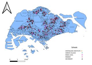
There are categorized by their school types and each data points is represented by different shape Initially i use mmqgis to plot the data points, but i realise that i have missing data as a result, hence, I use the code provided by our classmate to input the school data points
File history
Click on a date/time to view the file as it appeared at that time.
| Date/Time | Thumbnail | Dimensions | User | Comment | |
|---|---|---|---|---|---|
| current | 22:26, 16 September 2019 | | 3,507 × 2,480 (737 KB) | Cgfoo.2018 (talk | contribs) |
- You cannot overwrite this file.
File usage
The following page links to this file: