SMT201 AY2019-20G1 EX2 Ong Sin Kai Brendan
Contents
The Task
In this exercise, you are tasked to identify a location suitable for building a national Communicable Disease Quarantine Centre. The selected site must be located at Gombak planning subzone, with a contiguous area of at least 10,000m2 and it must meet the following decision factors:
- Economic factor: The selected site should avoid steep slope. This is because construction at steep slope tends to involve a lot of cut-and-fill and will lend to relatively higher development cost.
- Accessibility factor: The selected site should be close to existing local roads, namely: service roads and tracks. This is to ensure easy transportation of building materials during the construction stage.
- Health risk factor: The selected site should be away from population i.e. housing areas and offices in order to avoid disease spreading to the nearby population.
- Natural conservation factor: The selected site should be away from forested land, park and water.
Gombak Study Area
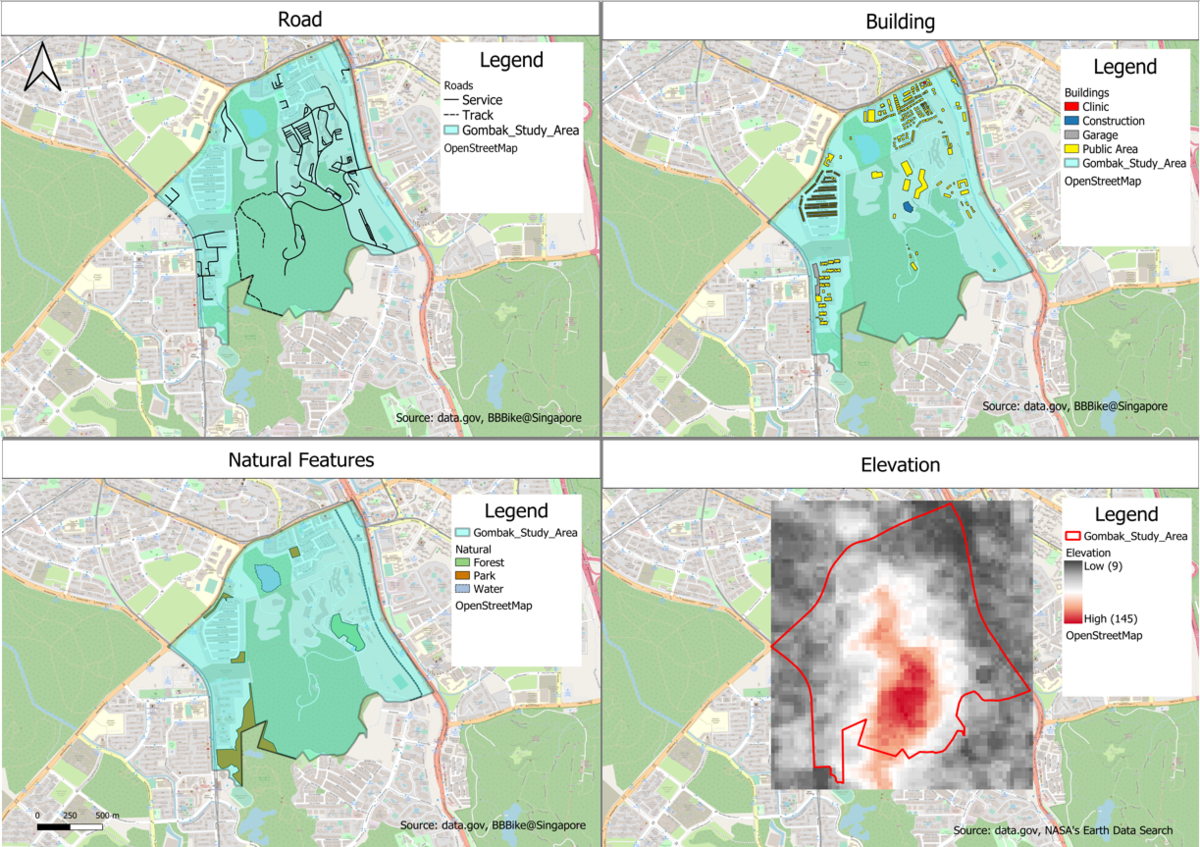
Accessibility (Roads): From a glance, we can see that the road network is much denser in the east region as compared to others. This is important as the new site location needs to be close to existing roads to ensure easy transportation of building materials. As such, it might be good to set up the site closer to the east region. The service roads are indicated with a straight black line and the tracks with a black dashed line for easy differentiation.
Health Risk (Building):The following areas were identified to have no impact on the location site selection, namely the clinic, garage and construction. A look through the dataset shows that most of the type of buildings were left empty. Hence, I assumed that those that were empty would fall under the residential areas. We can also see that the southern part of Gombak is void of residential buildings, making it a consideration for site selection as it must be away from the residential areas for health-related reasons.
Natural Conservation (Natural Features): We can see that most of the natural features fall in other regions except the south. As the site has to be away from the forest, parks and water, the southern part of Gombak would be a place to consider for the new building.
Economic (Elevation):We can see from the map that the Gombak has high elevation mostly in the southern area. As there is a need to avoid steep slopes for cost related reasons, it might not be viable to build the site in the southern area.
Proximity of Features and Slope Analysis of Gombak
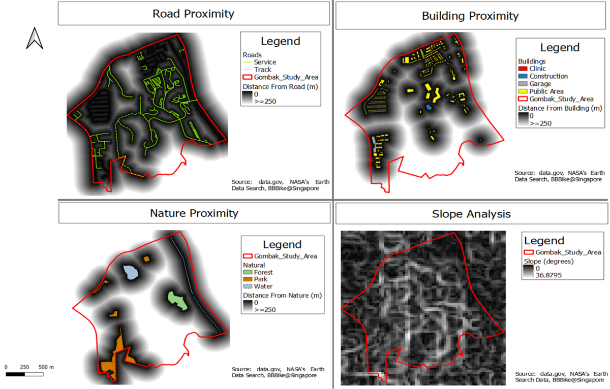
Road Proximity: Darker areas on the map indicate a better fit for the site location as it falls under the accessibility factor. The map shows that most of the region lies near the local roads except for a small area in the southern region. Any region that is below 250m would have a dark shade and any above would be shaded white.
Building Proximity: Whiter areas indicate a better fit for the site location as it falls under the health risk factor. From the map, we can see that our options for the site location is limited, being only able to build in the southern region due to the health risk factor and space constraint. Any region that is below 250m would have a dark shade and any above would be shaded white.
Nature Proximity: Whiter areas indicate a better fit for the site location as it falls under the Natural Conservation factor. Again, we can see from the map that only the center and southern region would meet the requirements for land site. Any region that is below 250m would have a dark shade and any above would be shaded white.
Slope Analysis: Darker areas on the map indicate a better fit for the site location as it falls under the economic factor. Since development cost is a concern, there is a need to choose a site with low elevation. From the slope analysis, we can see that the white and black shades are almost evenly covering the area, with a maximum steepness of 36.8795 degrees. As such, it might be difficult to meet the economic requirement.
Criterion Scores of Factors in Gombak
To calculate the criterion score, i used the Min-Max criteria standardization technique through the following formula: Standardized Score = (Proximity to Features - Min (Proximity to Features) / Max (Proximity to Features) - Min (Proximity to Features))
In the case of road and slope proximity analysis, i used the following formula to meet the factor requirements: Standardized Score = 1 - (Proximity to Features - Min (Proximity to Features) / Max (Proximity to Features) - Min (Proximity to Features))
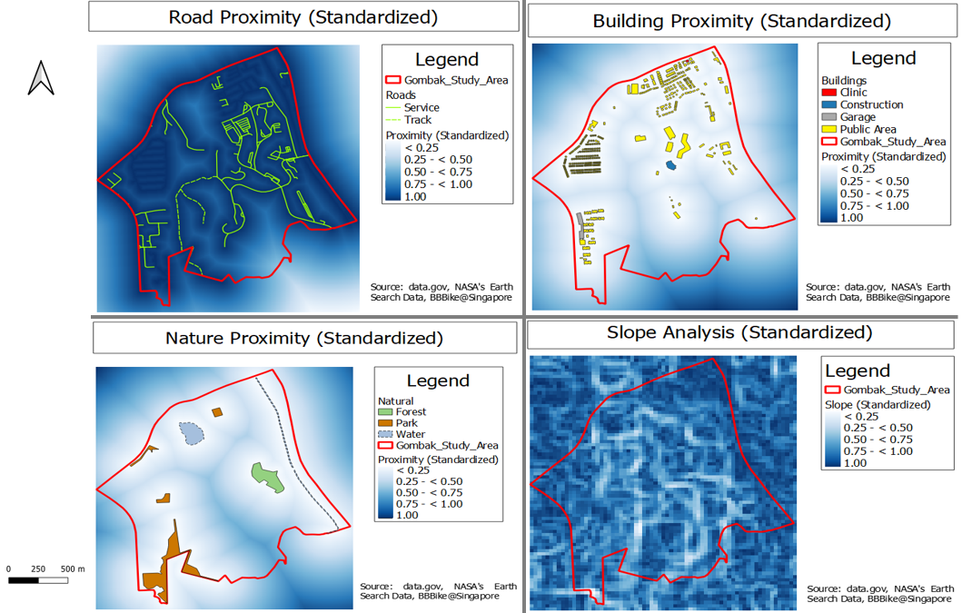
In the folllowing score maps, a higher score and darker region would indicate a better location fit for the new Centre.
Road Proximity Standardized: There is a need to use 1 minus the score as the accessibility factor is looking out for areas close to the local roads. From the map, regions that are darker indicate a closer distance to the local roads and will have a higher score, vice versa.
Building Proximity Standardized: The score can be taken as it is as we are looking for areas far from the public as required by the health risk factor. Similarly, regions that are darker indicate a further distance from the residential areas and will have a higher score, vice versa.
Nature Proximity Standardized: The score can be taken as it is as we are looking for areas far from nature as required by the nature conservation factor. Again, regions that are darker indicate a further distance from the natural features and will have a higher score, vice versa.
Slope Analysis Standardized: There is a need to use 1 minus the score as the economic factor requires us to look for areas with low steepness. Regions that are darker will indicate a lower steepness and get a higher score, vice versa.


