SMT201 AY2019-20G1 EX2 Sabrina Liau Ying Ying
Contents
Objectives
To identify a suitable site to build a National Communicate Disease Quarantine Centre in the target planning subzone, Gombak. It has to be a contiguous area of at least 10,000m2 and meet the following factors:
1) Accessibility factor: Close to existing local roads: service roads and tracks. To ensure easy transportation of building materials during the construction stage.
2) Health risk factor: Away from population: housing areas and offices. To avoid disease spreading to the nearby population.
3) Natural conservation factor: Away from forested land, park, and water.
4) Economic factor: Avoid steep slope. To reduce cut-and-fill and High development costs.
Map Layout: Study Area
Accessibility factor
Since the selected site for the Centre must be located near local roads, hence I extracted these roads and classified them according to their type: service and tracks. I used different colors to easier differentiate the different roads; red for service and blue for the track. In this map, there are a total of 186 service roads, mostly concentrated in the North-East region and 2 track roads located in the central region to the Southern region of Gombak
Health Risk Factor
Since the selected for the Centre must be located further away from the population, hence I decided to categories the buildings to understand the population flow. Based on my research, I differentiate the buildings into 3 main categories: residential, military, others. We can observe that the residential area is mostly concentrated in the northern region and southern-west region while the military area is concentrated from the central to the northern-east and to the southern region of Gombak.
Natural Conservation Factor
I used different colors to easier differentiate the different roads; brown for the forest, green for the park and blue for the waterbodies. There are a total of 1 forest, 4 parks, and 3 waterbodies located in Gombak. The forest and waterbodies are mostly located near the residential while the forest is near the military area.
Economic Factor
I used the single pseudocolor to differentiate the elevation of the Gombak area. From the map, we can observe that the Southern region has the highest elevation.
Map Layout: Proximity & Slope layers with the Study area
Accessibility factor
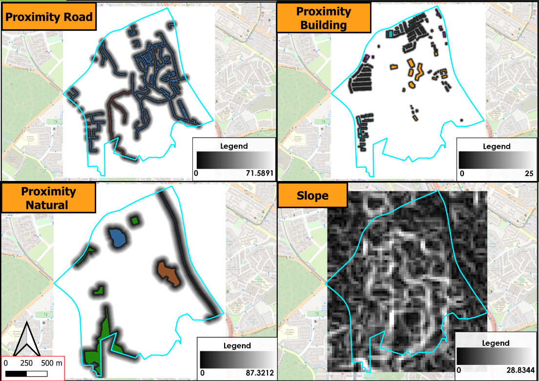
To get road proximity in Gombak, I rasterize the vector road layer to a raster layer. As we can observe, the land area that are nearer to the road is darker in color while the ones further are lighter in color. Since the selected site for the Centre must be nearer to the road, I should choose the darker color land area to ease the transportation of the materials during construction. The maximum distance of 5m by 5m land area from the map is 100m away from the road with the actual distance of 743m.
Health Risk Factor
To get building proximity in Gombak, I rasterize the vector building layer. As we can observe, the land area that is nearer to the road is darker in color while the ones further are lighter in color. Since the selected site for the Centre must be further away from the population: building, I should choose the lighter color land area to reduce the risk in exposing the Gombak residents with the disease. The maximum distance of 5m by 5m land area from the map is 100m away from the building with an actual distance of 838m.
Natural Conservation Factor
To get natural features proximity in Gombak, I rasterize the vector natural layer. As we can observe, the land area that is nearer to natural conservation is darker in color while the ones further are lighter in color. Since the selected site for the Centre must be further away from the natural conservation, I should choose the lighter color land area to minimize the risk of contaminating the resources. The maximum distance 5m by 5m land area from the map is 100m away from the natural features with the actual distance of 864m.
Economic Factor
To get the slope, I use slope raster analysis by using the elevation raster layer: DEM3. The legend shows the steepness ranging from 0 to 36.419 with the color from darker to lighter. Since the selected site for the Centre must be located at a more gentle slope, I should chose the darker area to lessen the need to cut-and-fill the land.
Criterion Scores
I used the Min-max method to standardize the score of the slope and the three other proximity layers: building, natural, and road.
Accessibility factor
After using the above method, the score has been standardized between 0 - 1. The score with 0, colored red, is the area nearest to the building and the score with 1, colored blue, is the area furthest away from the building. Hence, the area that is colored red is the most desired to build the Centre so that it is nearer to the rod for ease in transportation for constructing the Centre.
Health Risk Factor
After using the above method, the score has been standardized between 0 - 1. The score with 0, colored red, is the area nearest to the building and the score with 1, colored blue, is the area furthest away from the building. Hence, the area that is colored yellow to blue is more desired to build the Centre so that it is away from the population.
Natural Conservation Factor
After using the above method, the score has been standardized between 0 - 1. The score with 0, colored red, is the area nearest to the building and the score with 1, colored blue, is the area furthest away from the building. Hence, the area that is colored yellow to blue is more desired to build the Centre so that it is away from the natural conservation.
Economic Factor
After using the above method, the score has been standardized between 0 - 1. The score with 0, colored red, is the area with a gentle slope and the score with 1, colored blue, is the area with a steeper slope. Hence, the area that is colored red is more desired to build the Centre so that we can to reduce the cost when constructing the Centre.
Analytical Hierarchical Process: Input Matrix & Result
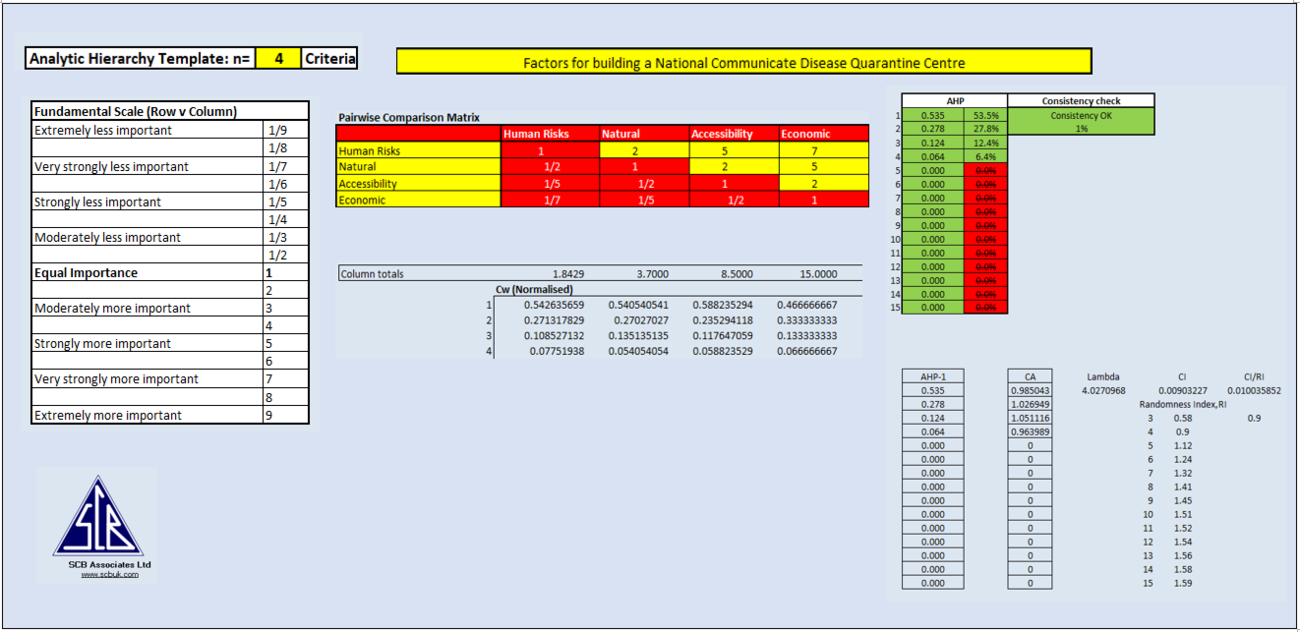
Through several consideration, I ranked the four decision factors in the following sequences: Health Risks, Natural Conservation, Accessibility and Economic . I believe that the main purpose of the Centre is to isolate patients from the other population who are healthy to prevent the spread of the disease. Hence, the Health risks factor is the most important factor.To further prevent the spread of the disease, it is important to minimize the contamination of the natural conservation as they are all located near the population. Hence, the Natural conservation factor is the next most important factor. Then, to allow the convenience of the transportation of the materials during construction and also the transferring of the patients, it is necessary for the Centre to be located near the local road. After considering all the above factors, the economic factor seems to be the least importance as money shouldn't be an issue in the face of a nation's crisis.
My AHP analysis is rather reliable and consistent as observed from the low consistency check of 1% that is within the required standard of less than 10%.


