File:MapLayout2.png
Revision as of 03:21, 10 November 2019 by Eddie.leow.2017 (talk | contribs)

Size of this preview: 800 × 566 pixels. Other resolutions: 320 × 226 pixels | 3,507 × 2,480 pixels.
Original file (3,507 × 2,480 pixels, file size: 1.03 MB, MIME type: image/png)
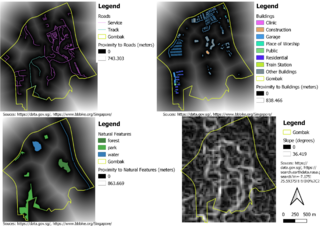
A map layout with four views showing Gombak and proximity to target road layer, Gombak and proximity to buildings layer, Gombak and proximity to target natural features layer, and Gombak and slope layer.
File history
Click on a date/time to view the file as it appeared at that time.
| Date/Time | Thumbnail | Dimensions | User | Comment | |
|---|---|---|---|---|---|
| current | 03:20, 10 November 2019 | | 3,507 × 2,480 (1.03 MB) | Eddie.leow.2017 (talk | contribs) |
- You cannot overwrite this file.
File usage
The following page links to this file: