SMT201 AY2019-20T1 EX2 Goh Jia Xin Genice
Contents
- 1 Overview of Task
- 2 Maps depicting the roads, buildings, natural areas and digital elevation in Gombak
- 3 Maps depicting the proximity to roads, buildings, natural areas and digital elevation in Gombak
- 4 Maps depicting criterion scores of proximity maps and slope in Gombak
- 5 Analytical Hierarchical Process (AHP) input matrix and result report
Overview of Task
We are intending to identify a suitable location site to build a national Communicable Disease Quarantine Centre within Gombak planning subzone. The location site should have a contiguous area of at least 10,000m2 and it must meet the following decisional factors:
- Accessibility Factor- Selected site should be close to local roads such as service roads and tracks
- Health-risk Factor- Selected site should be away from the population
- Natural Conservation Factor- Selected site should be away from natural areas
- Economic Factor- Selected site should avoid steep slope
More findings will be shared below.
Maps depicting the roads, buildings, natural areas and digital elevation in Gombak
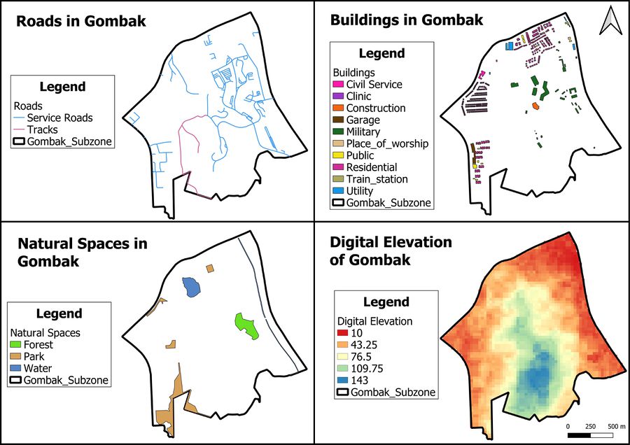
The following maps show the roads (accessibility factor), buildings (health-risk factor), natural areas (natural conservation factor) and digital elevation (economic factor) in Gombak.
Accessibility Factor (Roads)
The selected site should be close to existing local roads such as service roads and tracks, so as to ensure easy transportation of building materials during the construction stage. The service roads and tracks are labelled blue and pink on the map respectively. We can see that service roads are more extensive than tracks in Gombak planning subzone, because the northeastern part of Gombak has many service roads while there is only one stretch of tracks in the central part of Gombak.
Health-risk Factor (Buildings)
The selected site should be away from the population, such as residential areas and offices. This is to prevent the spreading of diseases to the nearby population. The majority of buildings in Gombak are residential buildings. The residential areas are mainly concentrated in the northern, western and southwestern parts of Gombak, while military landuse is concentrated in central Gombak.
Natural Conservation Factor (Natural Areas)
The selected site should be away from forested lands, parks and water. This serves to reduce the harm caused towards the wildlife and natural environment as a result of the construction of the national Communicable Disease Quarantine Centre. The forest, park and waterbody are labelled in green, brown and blue on the map respectively. They are generally spread out in Gombak, covering the eastern, northwestern and southern parts of the planning subzone.
Economic Factor (Slope)
The selected site should avoid steep slopes because the construction at steep slopes tends involve a lot of cut-and-fill and will lead to higher development costs. The smallest digital elevation value is 10m and is labelled in red, while the largest digital elevation value is 143m and is labelled in blue on the map.
Maps depicting the proximity to roads, buildings, natural areas and digital elevation in Gombak
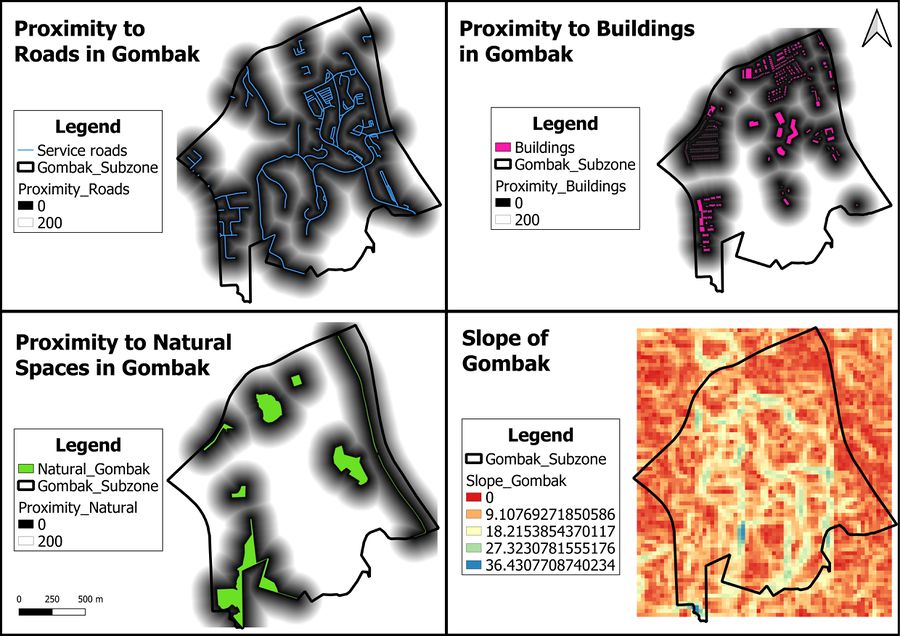
The proximity maps to roads, buildings and natural spaces in Gombak are standardised to show only the proximity range of 0 to 200m. This is to ensure that the three proximity maps can be uniformly compared against each other to gain insights on suitable location sites to build the national Communicable Disease Quarantine Centre.
Proximity to Roads
The darker spots on the map represent areas which are suitable for the building of the national Communicable Disease Quarantine Centre in terms of accessibility. The distance from a 5m by 5m land area to the nearest road is 0m while the furthest distance is 722.496m.
Proximity to Buildings
The lighter spots on the map represent areas which are suitable location sites for the national Communicable Disease Quarantine Centre in terms of health-risk. The distance from a 5m by 5m land area to the nearest building is 0m while the furthest distance is 826.62m.
Proximity to Natural Spaces
The lighter spots on the map represent areas which are suitable location sites for the national Communicable Disease Quarantine Centre in terms of natural conservation. The distance from a 5m by 5m land area to the nearest natural space is 0m while the furthest distance is 863.669m.
Slope in Gombak
The red areas on the map represent areas which are suitable location sites for the national Communicable Disease Quarantine Centre in terms of economic reasons. The smallest degree of slope in Gombak is 0 degrees, while the largest degree of slope is 36.431 degrees.
Maps depicting criterion scores of proximity maps and slope in Gombak
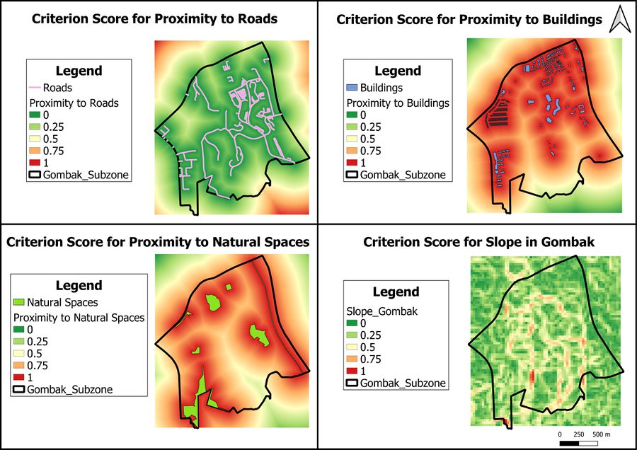
To create the criterion score maps, I had to inverse the raster pixel values for the proximity maps to buildings and natural spaces. This is because for maps depicting the slope in Gombak and proximity to roads, location sites are seen to be suitable if they have little slope and are close to roads. On the other hand, for maps depicting the proximity to buildings and natural spaces, location sites are seen to be suitable if they are further away from buildings and natural spaces.
| Factors | Criterion Scores |
|---|---|
| Accessibility | Proximity to Roads |
| Health-risk | 1 - Proximity to Buildings |
| Natural Conservation | 1 - Proximity to Natural Areas |
| Economic | Slope in Gombak |
Moreover, I had to standardise the scales across the maps using the min-max formula. This is because the proximity maps to roads, buildings and natural spaces in Gombak have different minimum and maximum values. In addition, the units used in the map depicting the slope in Gombak is in degrees and is different from the other maps which uses metres.
To achieve the steps above, I used the raster calculator in QGIS. The sample formula is as follows:
(Proximity Map to feature – Minimum Value of Proximity to feature) / (Maximum Value of Proximity to feature - Minimum Value of Proximity to feature)
Analytical Hierarchical Process (AHP) input matrix and result report


