SMT201 AY2019-20T1 EX2 Nicole Ng Linn
Contents
Map Layout with 4 Decision Factors
Gombak and Target Roads
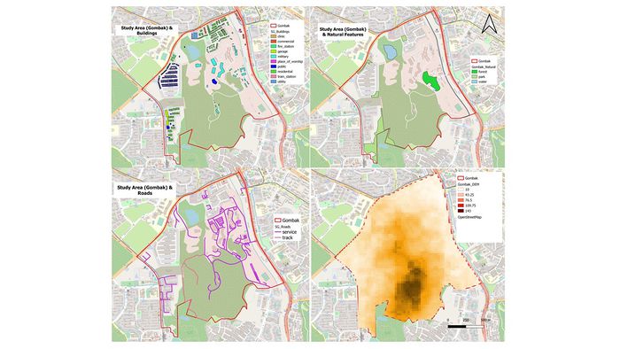
The selected site should be close to local roads to ensure easy transportation of building materials during the construction stage. The roads are shown in a line vector, and are categorized into service roads and tracks, which are shown using thicker strokes. The service roads spread across most of the Gombak planning subzone mostly located in the North-East region whereas the tracks are located in the Central region of Gombak and connecting to other roads in the South of Gombak.
Gombak and Buildings
The selected site should be away from the population to prevent diseases from spreading to the public. Out of the 527 buildings identified in Gombak, 505 buildings are of "unknown" type in the data provided. Hence, some changes to categorize the buildings were made based on their type from the OpenStreetMap. All buildings are treated as population indicators, and the selected site should be away from the buildings.
Gombak and Target Natural Features
The selected site should be also be away from natural features, such as forests, parks and water bodies. There are 1 forest, 4 parks and 3 water bodies identified. The forest is categorised in dark green on the map, while the parks and the water bodies are categorised using light green and light blue respectively.
Gombak and Digital Elevation
Finally, the selected site should avoid steep slopes to reduce the development costs for cut-and-fill construction techniques. The lowest point in Gombak is 10 meters above sea level, depicted in beige. The Southern region of Gombak has the highest elevation with 143 meters above sea level, depicted in dark brown. Only around 2% of the buildings and 5% of the local roads in Gombak are located in the region with the highest elevation. All the natural features are located within the low-lying areas of Gombak.
Map Layout with Proximity to 3 Decision Factors and Slope Layer
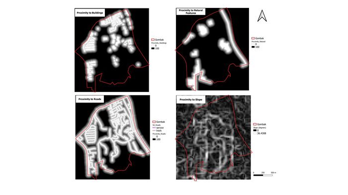
Gombak and Proximity to Target Roads Layer
Gombak and Proximity to Buildings Layer
Gombak and Proximity to Target Natural Features Layer
Gombak and Slope Layer
Map Layout With Criterion Scores
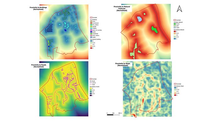
Normalised Criterion Score for Road Layer
Normalised Criterion Score for Building Layer
Normalised Criterion Score for Natural Feature Layer
Normalised Criterion Score for Slope Layer
AHP Scoring
For example, if the economic factor is in the row and accessibility factor is in the column, the corresponding value, 3, means that the economic factor is moderately more important the accessibility factor.
AHP Pairwise Comparison
1. Economic is moderately less important than Accessibility and Healthcare; is equally important to Nature Conservations. 2. Accessibility is strongly less important than Healthcare; is equally important to Nature Conservations. 3. Healthcare is moderately more important than Nature Conservations. 4. Natural Conservations is equally important to Economic and Accessibility; is moderately less important to Healthcare;


