G2-Group09 Proposal
| HOME | PROJECT REPORT |
| About Hsinchu, Taiwan |
|---|
Hsinchu is a city in northern Taiwan, southwest of the capital city of Taipei, also known as "The Windy City" for its windy climate. It’s also known for its ornate Hsinchu City God (Cheng Huang) Temple, lined with food stalls. Close by is Yin Hsi East Gate, a 19th-century structure once used as an entrance to the city. Hsinchu Zoo houses hippos, Bengal tigers and Malay bears. Southeast of the center, trails cross the forested Shibajian (18 Peaks) Mountain.
| Project Motivation |
|---|
Hsinchu Science Park in Hsinchu is home to over 360 high tech companies, and as a result, Hsinchu has the highest income level in Taiwan. In the future, the number of companies or the number of high tech investment make in this city is expected to rise further, which will potentially brings more business opportunities for the international fast food chain we are working with.
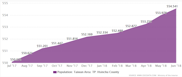
Additionally, based on Hsinchu population data gathered from CeciData shown below, it show that the population of Hsinchu is constantly growing and the population is expected to grow more in the future, which will garner more business opportunities for the international fast food chain.
Since there will be more business opportunities for the international fast food chain we are working with, we aim to utilize the data given to us to help the international fast food chain identify the most optimum location for business in Hsinchu to maximize their profits. Through identifying of optimum business location, we also aim to help the international fast food chain remain competitive among the ever-changing food and beverage industry in Hsinchu.
| Project Objective |
|---|
In this project, we will be conducting analysis on Hsinchu based on the following two considerations:
- Buffering
- Point of Interests near given stores
Our project will consist of the following tasks:
- Import relevant layers (e.g. country, town, village) into a single geopackage in QGIS
- Utilize advanced digitizing tools in QGIS to digitize relevant trade areas
- Filter out relevant Point of Interests and import it into QGIS
- Conduct analysis of the profitability of a store location using tools such as advanced digitizing and buffering
- Export the relevant maps substantiating our analysis
- Develop a wiki report that comprises of our analysis, with relevant maps embedded and visualized
All these tasks will help us come out with relevant methods (e.g. suggesting of new possible store locations or removal of current unprofitable stores) to improve the profits or sales of the international fast food chain in Hsinchu.
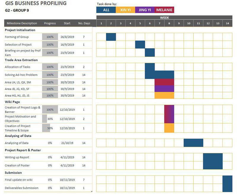
| Project Timeline |
|---|


