File:Road Network in Singapore.png
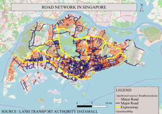
Revision as of 00:26, 16 September 2019 by Mabelletham.2018 (talk | contribs) (Data sourced from LTA did not have distinctly categorized road types, hence I used QGIS to categorize the roads by Road Type – categorizing them into Expressways, Major Roads and Minor Roads segregating them by colour and thickness.)

Size of this preview: 800 × 566 pixels. Other resolutions: 320 × 226 pixels | 1,200 × 849 pixels.
Original file (1,200 × 849 pixels, file size: 1.24 MB, MIME type: image/png)
Summary
Data sourced from LTA did not have distinctly categorized road types, hence I used QGIS to categorize the roads by Road Type – categorizing them into Expressways, Major Roads and Minor Roads segregating them by colour and thickness.
File history
Click on a date/time to view the file as it appeared at that time.
| Date/Time | Thumbnail | Dimensions | User | Comment | |
|---|---|---|---|---|---|
| current | 00:26, 16 September 2019 | | 1,200 × 849 (1.24 MB) | Mabelletham.2018 (talk | contribs) | Data sourced from LTA did not have distinctly categorized road types, hence I used QGIS to categorize the roads by Road Type – categorizing them into Expressways, Major Roads and Minor Roads segregating them by colour and thickness. |
- You cannot overwrite this file.
File usage
The following page links to this file: