SMT201 AY2019-20T1 EX1 Lee Yuan Kang
Revision as of 21:40, 15 September 2019 by Yklee.2017 (talk | contribs) (→Hierarchy of road network system of Singapore)
Part 1 : Thematic maps
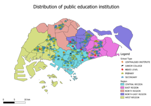
Distribution of public education institution
The based map is using the Master Planning 2014 map from data.gov.sg. Using Master Planning map will be easier to visualise as the image is clean. It is segregated based in the region with different colours. For all the points within the map are the different level of schools, and they are labelled with different icons and colours for the user to easily identify the location of the school.
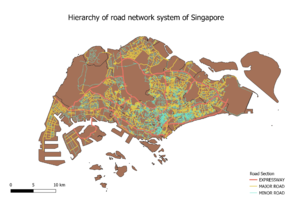
Hierarchy of road network system of Singapore
The background of the road is using MP planning area, which is clean and easy to visualise. The road is split by expressway, major roads and minor roads based on their road name. For example, highway and expressway will categorise as expressway under road type. The expressway will have bigger lines as it will be easier to identify.

