Project Proposal
|
Living in the digital age, many companies have adopted various kind of technologies to improve their profitability and competitiveness in order to stay in the market. In this project, our client was a multinational company and want to see what to improve on with the given data. We were motivated to take on this project because we can use this opportunity to apply our knowledge and understanding of what is taught in class into a real-life application. Another motivation was to explore new area that is not in the Singapore context. My team was assigned to several areas in Taiwan. With the data provided, we were able to gain insight into the past through the descriptive analysis and apply our knowledge on geospatial analysis that was taught in class. With that, we can understand what might happen through predictive analysis. And conclude any possible ways to increase their customer base in the given area. Throughout this project, we hope to deliver a meaningful analysis for our client and also gain relevant skills in the workforce. |
|---|
|
Our team objectives for 12 given outlets:
|
|---|
|
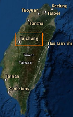
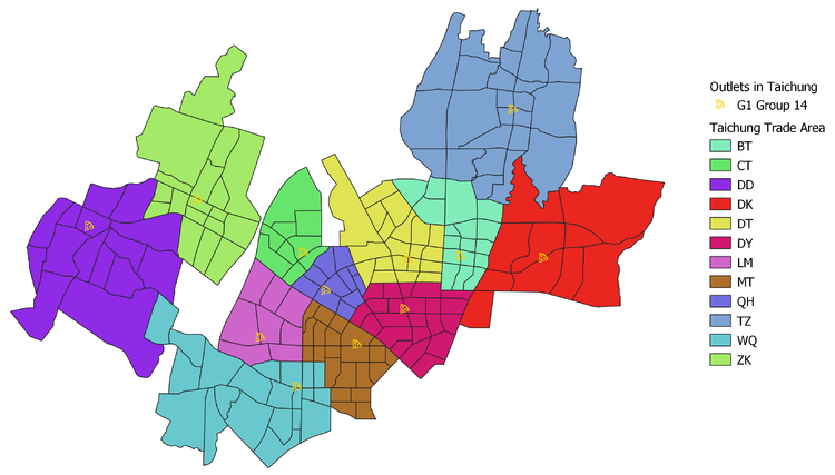
We were assigned with Taichung area. With the data given, there were 12 trade areas. we digitize them according to Taichung area. 
|
|---|
| Dataset | Purpose | Data Type | Remark |
|---|---|---|---|
| GeoPackage | |||
| Taiwan_stores | List of stores | .gpkg | |
| geo_majHwys | Show the road lines | .gpkg | |
| Raster Image | |||
| ASTGTMV003_N24E120_dem | Get the digital elevation | .tif | Retrieve from Earthexplorer |
| Admin Boundaries | |||
| COUNTY_MOI_10 | Contains county boundary | .shp | |
| VILLAGE_MOI_121 | Contains village boundary | .shp | |
| TOWN_MOI_1080 | Contains town boundary | .shp | |
| Location Maps | |||
| BT-20171218寬83高88(木)含框 | Location of store | .pptx | |
| CT-20180921寬66高85(鋁)含框 | Location of store | .pptx | |
| DD-20171218寬75高比例(木) | Location of store | .pptx | |
| DK-20171218寬100高88(木)含框 | Location of store | .pptx | |
| DT-20171208寬90高100(木)含框 | Location of store | .pptx | |
| DY-20171012寬85高72(鋁)含框 | Location of store | .pptx | |
| LM-20190325寬73高90(鋁)含框 | Location of store | .pptx | |
| MT-20171207寬72高84(木)含框 | Location of store | .pptx | |
| QH-20180822寬65高70(鋁) | Location of store | .pptx | |
| TZ-20150907寬86高92(木) | Location of store | .pptx | |
| WQ寬105高96(木)含框 | Location of store | .pptx | |
| ZK-20171110寬80高95(木)含框 | Location of store | .pptx | |
| Points of Interest(POI) | |||
| Business | Locations of businesses | .shp | - BUSINESS FACILITY - INDUSTRIAL-ZONE |
| Eduinst | Locations of education | .shp | - HIGHER-EDUCATION - SCHOOL |
| Entertn | Locations of entertainment | .shp | - NIGHTLIFE - CINEMA - PERFORMING-ARTS - BAR-OR-PUB |
| Hospital | Locations of hospital | .shp | - HOSPITAL - MEDICAL-SERVICE |
| Shopping | locations of shopping | .shp | - GROCERY-STORE - SHOPPING - CONVENIENCE-STORE - CLOTHING-STORE - DEPARTMENT-STORE - SPECIALITY-STORE - CONSUMER-ELECTRONICS-STORE - BOOKSTORE - PHARMACY |
| FinInsts | Locations of financial | .shp | - ATM - BANK |
| TravDest | Locations of travel | .shp | - HOTEL |
| Transhub | Locations of transport | .shp | - TRAIN-STATION - BUS-STATION |
| MiscCategories | Locations of building | .shp | - RESIDENTIAL-AREA/BUILDING |
| Restrnts | locations of restaurant | .shp | - RESTAURANT - COFFEE-SHOP |
| CommSvc | Contains locations of community service | .shp | - GOVERNMENT-OFFICE |
| ParkRec | Contains locations of park and recreation | .shp | - BOWLING-CENTRE - SPORTS-COMPLEX - SPORTS-CENTRE |

