SMT201 AY2019-20T1 EX2 Darren Tan Yong Heng
Contents
- 1 Take-home Exercise 2
- 2 Maps depicting the target features within Gombak - Roads, Buildings, Natural Areas and Slope
- 3 Gombak proximity to features (Buildings, Natural Areas, Roads and Slope)
- 4 Gombak Subzone Criterion Score (Natural Areas, Roads, Buildings and Slope)
- 5 Analytical Hierarchical Process (AHP) Matrix
- 6 Map of suitable land lot(s) in Gombak
Take-home Exercise 2
In this exercise, you are tasked to identify a location suitable for building a national Communicable Disease Quarantine Centre. The selected site must be located at Gombak planning subzone, with a contiguous area of at least 10,000m2 and it must meet the following decision factors:
- Economic factor: The selected site should avoid steep slope. This is because construction at steep slope tends to involve a lot of cut-and-fill and will lend to relatively higher development costs.
- Accessibility factor: The selected site should be close to existing local roads, namely: service roads and tracks. This is to ensure easy transportation of building materials during the construction stage.
- Health risk factor: The selected site should be away from population i.e. housing areas and offices in order to avoid disease spreading to the nearby population.
- Natural conservation factor: The selected site should be away from forested land, park, and water.
Maps depicting the target features within Gombak - Roads, Buildings, Natural Areas and Slope
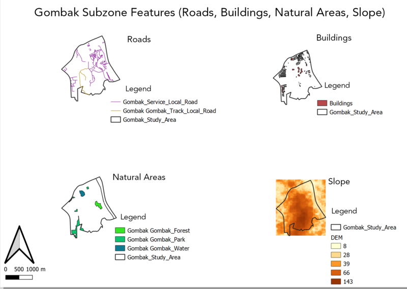
The following map images depict factors taken into consideration for building a national Communicable Disease Quarantine Centre within Gombak. The four key factors are as follows - Accessibility Factor (Roads), Health Risk Factor (Buildings), Natural Conservation Factor and Economic Factor (Slope).
Accessibility Factor (Roads)
The task requires us to choose existing local routes namely: service roads and tracks. Hence, the image above depicts service and track roads within Gombak and ideally the new quarantine center should be built near to these roads identified to ensure easy transportation of building materials during the construction stage.
Health Risk Factor (Buildings)
Due to the sheer amount of buildings that are unlabelled, I choose to represent all the buildings using a single color code. However, it is still important to consider the position of the buildings within the map as the quarantine center needs to situated away from the population to avoid disease spreading to the nearby population.
Natural Conservation Factor
There are 3 main types of natural features within Gombak, namely forest, park, and water. The natural areas are located close to the edge of Gombak, with parks located close to the southern border of Gombak. Forest is located in the eastern part of Gombak and water is located near the northern tip of Gombak. As part of the task, it is essential to find a building spot located far away from natural areas.
Economic Factor (Slope)
The darker areas indicate that the slope within the area is steeper and likewise the lighter areas indicate areas with gentler slopes. Hence, it is important to avoid the darker areas as it corresponds to higher development cost.
Gombak proximity to features (Buildings, Natural Areas, Roads and Slope)
Proximity to Buildings
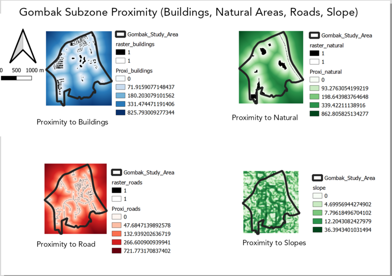
The proximity of buildings ranges from 0 to 825.7 meters. The darker shades of blue represent areas which are far away from buildings, conversely areas which are in lighter shades of blue or white are very close to buildings. As the new quarantine center needs to be built far away from residential buildings /offices/areas with a dense population, hence the areas in a darker shade of blue are the ideal locations to build the quarantine center.
Proximity to Natural Areas
The proximity of nature ranges from 0 to 862.8 meters. Areas in a darker shade of green represent a further distance away from natural areas and areas in a lighter shade of green or white represent a closer distance to natural areas. As described in the task, the quarantine center needs to be located far away from forested land, parks, and water. Hence it is more ideal to build the quarantine center in areas that are shaded in dark green.
Proximity to Road
The proximity of road ranges from 0 to 721.7 meters. Areas shaded in white are closer to local roads and are the ideal location to build the quarantine center as it helps ensure easy transportation of materials during construction. On the other hand, the areas shaded red of increasing intensity should be avoided, due to the far distance away from local roads.
Proximity to Slope
Slope ranges from 0 to 36.3 meters. Steep slopes are avoided as it leads to an increase in development cost due to cut-and-fill. Therefore, areas in the lighter shade of green and white are preferred as it is less elevated.
Gombak Subzone Criterion Score (Natural Areas, Roads, Buildings and Slope)
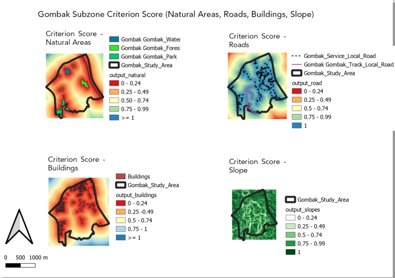
The image below shows the criterion scores of the following features - Natural areas, Roads, Buildings and Slope. The criterion scores are obtained using the min-max normalization formula shown below. A score range from 0 to 1 is obtained. A score closer to 1 indicates that the area is more suitable for the construction of the quarantine center.
Criteria Standardisation Technique
Image obtained from https://www.oreilly.com/library/view/regression-analysis-with/9781788627306/assets/ffb3ac78-fd6f-4340-aa92-cde8ae0322d6.png
Criterion Score (Natural Areas)
("Prox_Natural@1" - 0) / (862.805825134277 - 0)
The further the distance away from a natural area the more ideal the location, hence areas with values close to 1 are preferred and areas shaded in red should be avoided.
Criterion Score (Roads)
("Prox_Roads@1" - 0) / (721.773170837402 - 0)
The nearer the proximity from the local road the more ideal as it reduces development cost. Hence areas with shaded in blue with values closer to 1 are preferred.
Criterion Score (Buildings)
("Prox_Buildings@1" - 0) / (825.793009277344 - 0)
The further the distance away from buildings the more ideal the location, hence areas with values close to 1 are preferred and areas shaded in red should be avoided.
Criterion Score (Slope)
("Slope_DEM@1" - 0) / (36.3943401031494 - 0)
Construction at steep slopes involves a lot of cut-and-fill and generally leads to higher development costs. Hence, areas with a value close to 1 are preferred as it indicates that the area has a gentler slope.
Analytical Hierarchical Process (AHP) Matrix
Rationale
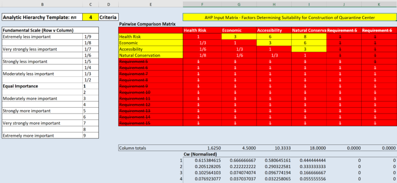
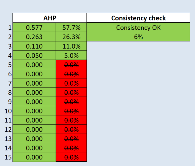
Based on the calculation derived from the AHP matrix, the score for the respective factors are as follows:
- Health Risk: 0.57
- Economic: 0.26
- Accessibility 0.11
- Natural Conservation: 0.05
The result (6%) obtained from the consistency check was below the recommended threshold of 10%, hence I decided to proceed with the usage of the values obtained from the AHP matrix.
Evidently, health risk is prioritized over other factors as the main purpose of the quarantine center is to prevent the spread of diseases. Economic (Accessibility), is second in the priority list, as high development cost may defer the timeline to build the quarantine center. Accessibility is placed third in the priority list, as it is not evident that better logistics planning will prove to be advantageous for the operation of the quarantine center. Lastly, natural conservation is placed at the bottom of the priority list as the construction of the quarantine center is still possible when the forested areas are eradicated. However, the authorities may face challenges from environmental activists and hence it is essential to not overlook the importance of preserving natural areas despite it being deprioritized when compared to the other three factors.
Map of suitable land lot(s) in Gombak
Conclusion
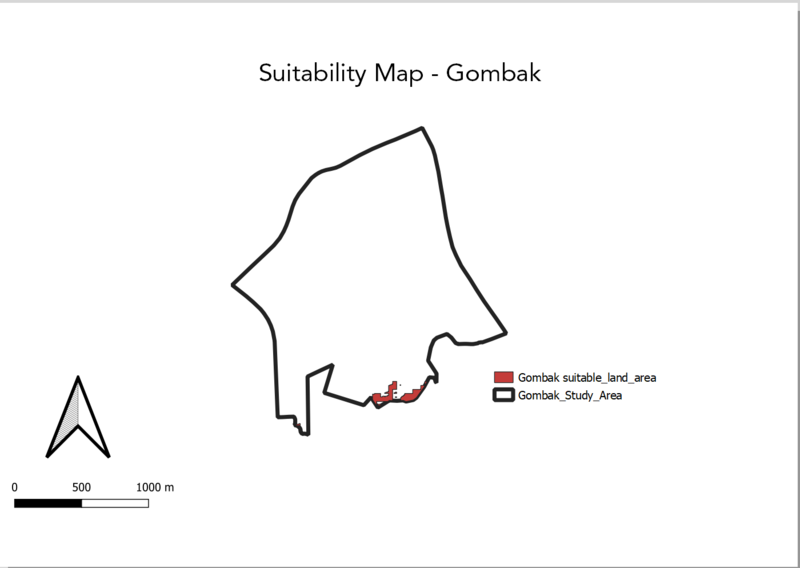
I used the raster calculator to derive the raster map, thereafter I vectorized the raster map and proceeded with clipping the vectorized layer with the Gombak layer.
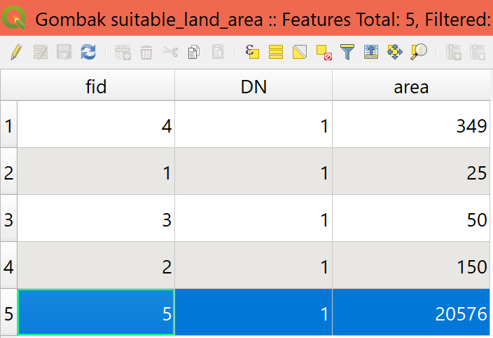
The atrribute table above shows that there is only one plot of suitable land with land area above 10,000m², hence it is selected as the final land lot deemed suitable for the construction of the quarantine center.
