SMT201 AY2019-20T1 EX2 Jaslyn Wong
Contents
Motivation of this Take Home Exercise
Motivation of this exercise is to identify a location suitable for building a national Communicable Disease Quarantine Centre with the following decision factors:
- Selected site must be located at Gombak planning subzone, with a contiguous area of at least 10,000m2
- Economic factor: The selected site should avoid steep slope to reduce higher development cost.
- Accessibility factor: The selected site should be close to service roads and tracks to ensure easy transportation of building materials during the construction stage.
- Health risk factor: The selected site should be away from population i.e. housing areas and offices in order to avoid disease spreading to the nearby population.
- Natural conservation factor: The selected site should be away from forested land, park and water.
Part 1
Roads
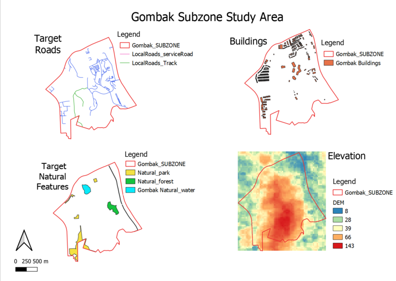
In the map, I extracted the local roads, mainly service roads and tracks. We can imply from the map that there are more tracks than service roads.
Buildings
In the map, we can see that there are only a few buildings that is located in the southern east side of Gombak. Most buildings are clustered in the northern and west area of Gombak. The buildings are generally clustered together whenever one building is seen in that area. This shows that the Quarantine centre can possibly be located near the southern side of Gombak as there are lesser buildings in that area.
Natural features
In the map, we can see that the parks are general at the sides of Gombak area. There is a line of water, located in the east of Gombak which might possibly be a canel or river. This means that the east of Gombak might not be a suitable location for the Quarantine centre.
Slope/Elevation
In this area, I used 5 classes to show the elevation. Red showing the highest value, which means that red area has a steeper slope and blue area implies lower or no slope.
Part 2
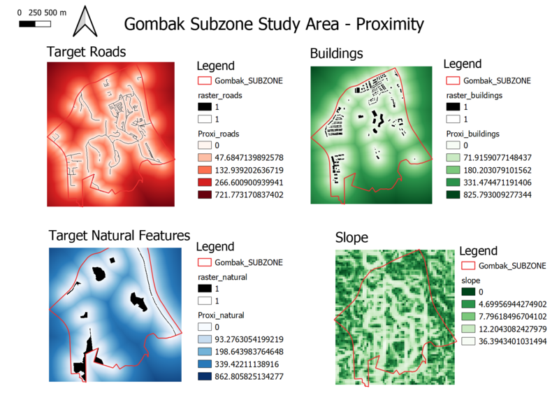
Quantile is used for all proximities' mode.
Proximity Raster for Roads
Meaures are as follows:
Min value = 0, Max value = 721.773170837402 with a resolution of 5 x 5
However, we want to build the Quarantine centre nearer to the local roads so that it is easier to move the materials over for construction, hence, I changed the min and max value to the following instead:
Min value = 721.773170837402, Max value = 0 with a resolution of 5 x 5
Proximity Raster for Buildings
Meaures are as follows:
Min value = 0, Max value = 825.793009277344 with a resolution of 5 x 5
Proximity Raster with Natural Areas
Meaures are as follows:
Min value = 0, Max value = 862.805825134277 with a resolution of 5 x 5
Slope Raster Layer
Meaures are as follows:
Min value = 0, Max value = 36.3943401031494 with a resolution of 30 x 30
However, we want to get the steeper slope with the least score when doing criterion score in the next part of this exercise so that steeper slope will not be a better suit for building the Quarantine centre, I changed the min and max value to the following instead:
Min value = 36.3943401031494, Max value = 0 with a resolution of 30 x 30
Part 3
Criterion Score for Roads
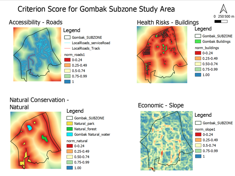
The higher the criterion score, the better the result for accessibility. As seen in the result above, the highest score is stated on the road. This is correct because we want the Quarantine centre to be build nearer to the road for the convenience of moving the materials during construction.
Criterion Score for Buildings
The higher the criterion score, the better the result for buildings. As seen in the result above, the highest score is stated away from the building. This is correct because we want the Quarantine centre to be build further away from the population so that it will avoid spreading disease to the nearby population.
Criterion Score for Natural Areas
The higher the criterion score, the better the result for natural conservation areas. As seen in the result above, the highest score is stated away from the natural conservation areas. This is correct because we want the Quarantine centre to be build further away from the forested land, water and park.
Criterion Score for Slope
The higher the criterion score, the better the result for the slope. As seen in the result above, the highest score is stated away from the steeper slopes. This is correct because we want the Quarantine centre to avoid slopes so that it will not increase the development cost.


