Uncategorised files
Jump to navigation
Jump to search
Showing below up to 50 results in range #2,661 to #2,710.
View (previous 50 | next 50) (20 | 50 | 100 | 250 | 500)
 ThematicMapRoadSectionLine.jpg 3,507 × 2,480; 1.61 MB
 ThematicMap Schools.jpg 3,507 × 2,480; 1.35 MB
 Thematic - SchoolTypes.jpg 1,055 × 515; 78 KB
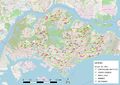
 Thematic map showing the distribution of public education institution by school types.png 3,507 × 2,480; 1.26 MB
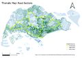
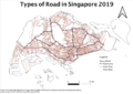
 Thematic map showing the hierarchy of road network system of Singapore.png 3,507 × 2,480; 1.77 MB
 ThematicmapEducation.jpg 3,507 × 2,480; 1.53 MB
 Thematicmap 1.png 3,507 × 2,480; 931 KB
 Theoretical vs Actual Pic.jpg 1,909 × 2,000; 332 KB
 Timeline.JPG 927 × 547; 131 KB
 Timeline.jpg 927 × 547; 131 KB
 Timeline.png 1,335 × 595; 45 KB
 TimelineG1G5.png 1,614 × 622; 55 KB
 TimelineVer1.jpg 1,075 × 889; 130 KB
 Timeline G2G13.png 2,546 × 796; 675 KB
 Timeline G2G8.png 1,348 × 1,470; 870 KB
 Timelinescope.png 1,186 × 817; 54 KB
 Timelinescope2.png 1,183 × 823; 53 KB
 Title - Highway to Taipei.png 2,100 × 314; 13 KB
 Tobepolygonized.png 919 × 766; 661 KB
 Toc.jpg 653 × 306; 11 KB
 Toc2.jpg 277 × 40; 4 KB
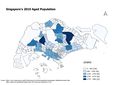
 Total Aged Population in Each Subzone for 2010 without labels.jpg 3,507 × 2,480; 841 KB
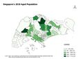
 Total Aged Population in Each Subzone for 2018 without labels.jpg 3,507 × 2,480; 838 KB
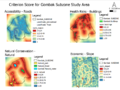
 Total Criteria Scores.jpg 2,104 × 1,488; 207 KB
 Total population in cck.png 612 × 344; 18 KB
 Tpyishun.jpg 708 × 419; 38 KB
 TradeArea.png 3,293 × 1,876; 526 KB
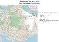 Train Travel.jpg 3,507 × 2,480; 1,024 KB
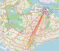 Train Travel zoomed.jpg 1,270 × 1,103; 366 KB
 Transformation matrix.png 1,366 × 361; 73 KB
 Transport.png 724 × 403; 35 KB
 Travelling pattern cck.jpg 889 × 522; 81 KB
 Two thousand eighteen.jpg 2,338 × 1,652; 439 KB
 Two thousand ten.jpg 2,338 × 1,652; 443 KB
 Type of Road.png 1,706 × 1,204; 1.23 MB
 TzyAboveandequal65(2010.png 1,843 × 1,126; 239 KB
 TzyLanduse.png 800 × 565; 125 KB
 TzyMorethan65('18').png 800 × 565; 101 KB
 TzyProportion(2010).png 800 × 565; 74 KB
 TzyProportion(2018).png 800 × 565; 80 KB
 TzyRoadnetwork.png 1,530 × 698; 529 KB
 Tzy change.png 3,507 × 2,480; 741 KB
 Unclippedfinalraster.png 829 × 770; 325 KB
 Untitled.jpg 1,017 × 721; 334 KB
 Update gombakPart3.png 1,338 × 1,004; 449 KB
 Updated gantt chart.png 1,120 × 688; 56 KB
 Updated project timeline.png 2,483 × 1,750; 454 KB
 UrbanGIS.jpg 600 × 432; 127 KB
 Values.png 403 × 369; 12 KB
 Vector.jpeg 4,960 × 3,507; 1.84 MB


.png)
.png)
.png)


