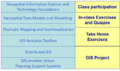
Uncategorised files
Jump to navigation
Jump to search
Showing below up to 50 results in range #2,431 to #2,480.
View (previous 50 | next 50) (20 | 50 | 100 | 250 | 500)
 SelectedLandLotFinal.png 1,696 × 2,260; 213 KB
 SelectedLandLotOBO.png 1,805 × 1,263; 135 KB
 Selected Land.jpg 982 × 693; 114 KB
 Selected Site1.png 1,273 × 555; 474 KB
 Selected Sitesab.png 917 × 624; 344 KB
 Selection of Suitable Lot (Su Yee).png 3,507 × 2,480; 298 KB
 Serangoon.jpg 1,280 × 905; 111 KB
 Serangoon 1.jpg 3,507 × 2,480; 1.07 MB
 Sgmasterplan.jpg 3,504 × 2,480; 1.17 MB
 Sgroadnetworksystem.jpg 3,507 × 2,480; 632 KB
 Sign.jpg 275 × 48; 4 KB
 Silver zone.png 512 × 512; 22 KB
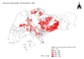
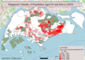 Singapore's Density of Population Aged 65 and Above (2010).png 1,681 × 1,189; 1.26 MB
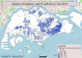 Singapore's Density of Population Aged 65 and Above (2018).png 1,681 × 1,189; 1.11 MB
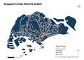
 SingaporeRoadNetworkSystem.png 1,127 × 799; 207 KB
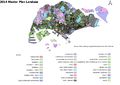
 Singapore 2014 Master Plan Landuse.png 1,169 × 826; 952 KB
 Singapore Aged Population 2010.png 3,507 × 2,480; 958 KB
 Singapore Aged Population 2018.png 3,507 × 2,480; 919 KB
 Singapore Land Use.png 3,507 × 2,480; 1.25 MB
 Singapore Land Use MP14.png 1,201 × 852; 524 KB
 Singapore Landuses 2014.png 2,923 × 2,066; 1.64 MB
 Singapore Master Plan 2014 Land Use.png 3,507 × 2,480; 1.49 MB
 Singapore Master Plan 2014 Landuse.png 3,000 × 1,791; 1.75 MB
 Singapore Road Network System.png 3,507 × 2,480; 1.72 MB
 Singapore Road Sections(Updated).png 3,507 × 2,480; 1.7 MB
 Singapore School Map.jpg 831 × 557; 54 KB
 Singapore aged population (65 and above) in 2010.png 3,507 × 2,480; 961 KB
 Singapore aged population (65 and above) in 2018.png 3,507 × 2,480; 933 KB
 Site.1.png 1,340 × 732; 146 KB
 Site.2.png 1,353 × 741; 146 KB
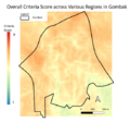
 Siti G2 4Views Criterion.PNG 716 × 671; 523 KB
 Siti G2 4Views Normal.PNG 868 × 701; 661 KB
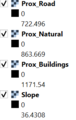
 Siti G2 4Views Proximity.PNG 613 × 701; 359 KB
 Siti G2 AHP Part1.PNG 1,689 × 579; 56 KB
 Siti G2 AHP Part2.PNG 632 × 493; 19 KB
 Siti G2 Consolidation.PNG 551 × 513; 211 KB
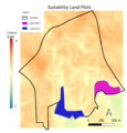 Siti G2 Land Plots.PNG 558 × 580; 258 KB
 Siti G2 OrigRange.PNG 202 × 320; 6 KB
 Siti G2 QGIS Consolidation.jpg 1,280 × 695; 113 KB
 Size.jpg 1,490 × 759; 94 KB
 Slope.jpg 3,507 × 2,480; 375 KB
 Slope1.png 470 × 372; 57 KB
 SlopeContour1.png 625 × 464; 175 KB
 SlopeGombakJ.jpg 2,800 × 1,979; 617 KB
 Slope Layer.jpg 887 × 903; 116 KB
 Slope of gombak.jpeg 3,507 × 2,480; 555 KB
 Slopestd.png 249 × 318; 83 KB
 Smt module.jpg 1,383 × 815; 56 KB
 SpaceCombined.jpg 2,230 × 1,402; 280 KB
 Stand.jpg 260 × 73; 11 KB


.png)


.png)
.png)


.png)

_in_2010.png)
_in_2018.png)


