Uncategorised files
Jump to navigation
Jump to search
Showing below up to 50 results in range #2,201 to #2,250.
View (previous 50 | next 50) (20 | 50 | 100 | 250 | 500)
 Qgislogo.png 600 × 550; 14 KB
 Qn1.png 2,338 × 1,653; 461 KB
 Qn1 edited.png 2,338 × 1,653; 466 KB
 Qn1 edited2.png 2,338 × 1,653; 470 KB
 Qn2.png 2,338 × 1,653; 1.1 MB
 Qn2 edited.png 2,338 × 1,653; 1.06 MB
 Qn3.png 2,338 × 1,653; 1.08 MB
 Qn5-1.png 1,531 × 1,080; 1.91 MB
 Qn5.png 2,338 × 1,653; 474 KB
 Quarantine-1313617-1279x263.jpg 1,279 × 264; 247 KB
 QuestionOnePartThree.jpg 2,400 × 1,696; 567 KB
 QuestionOnePartTwo.jpg 2,400 × 1,697; 457 KB
 QuestionTwoPartOne2010.jpg 2,400 × 1,697; 304 KB
 QuestionTwoPartOne2018.jpg 2,400 × 1,697; 333 KB
 QuestionTwoPartTwo2010.jpg 2,400 × 1,697; 292 KB
 QuestionTwoPartTwo2018.jpg 2,400 × 1,697; 322 KB
 Question One Part One.png 2,400 × 1,697; 395 KB
 R1.png 942 × 883; 46 KB
 Random Index.png 348 × 509; 14 KB
 Randomness index.jpg 1,268 × 734; 94 KB
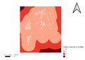 Ranked proximity to building.jpg 3,507 × 2,480; 249 KB
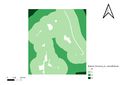 Ranked proximity to natural features.jpg 3,507 × 2,480; 224 KB
 Ranked proximity to road.jpg 3,507 × 2,480; 281 KB
 Ranked slope.jpg 3,507 × 2,480; 245 KB
 Rankedproximitytobuilding.png 958 × 615; 65 KB
 Rankedproximitytonaturalfeatures.png 966 × 629; 67 KB
 Rankedproximitytoroad.png 964 × 627; 66 KB
 Rankedslope.png 963 × 611; 66 KB
 Ranking Chart.png 486 × 570; 28 KB
 Rasdsadsadsaa2.png 2,212 × 1,572; 337 KB
 RasterCalc.PNG 1,141 × 811; 74 KB
 RasterCalculatorToCompileFactorsBasedOnAHP.JPG 1,363 × 960; 227 KB
 Raster Calc.jpg 1,440 × 996; 169 KB
 Raster Calculating Method.PNG 1,233 × 927; 82 KB
 Raster Calculator.png 1,151 × 813; 77 KB
 Raster Calculator for land lot suitability NXJ.JPG 1,210 × 964; 185 KB
 Raster calc.png 1,229 × 531; 55 KB
 Raster calc AHP.jpg 1,457 × 1,036; 175 KB
 Raster intersection suitability NXJ.jpeg 3,507 × 2,480; 937 KB
 Rastercalculator.png 758 × 725; 70 KB
 Rasterised buildings of gombak.jpeg 3,507 × 2,480; 358 KB
 Rasterised natural features of gombak.jpeg 3,507 × 2,480; 314 KB
 Rasterised roads of gombak.jpeg 3,507 × 2,480; 388 KB
 Rastersab2.png 923 × 652; 503 KB
 Rastersabby.png 1,104 × 781; 774 KB
 Rastertovector.jpg 823 × 784; 54 KB
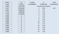
 Ratio.png 1,238 × 732; 35 KB
 Raw data overview.jpg 1,314 × 93; 28 KB
 Reclassified.png 1,213 × 684; 195 KB
 Reclassified suitability 50.jpg 3,507 × 2,480; 248 KB


