Unused files
Jump to navigation
Jump to search
The following files exist but are not embedded in any page. Please note that other web sites may link to a file with a direct URL, and so may still be listed here despite being in active use.
Showing below up to 50 results in range #151 to #200.
View (previous 50 | next 50) (20 | 50 | 100 | 250 | 500)
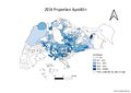
 New 2010 Proportion Aged65+.jpg 3,507 × 2,480; 456 KB
 New 2018 Proportion Aged65+.jpg 3,507 × 2,480; 461 KB
 School Map1.jpg 3,377 × 2,362; 1.18 MB
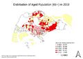
 Aged Population (+65) In 2010.png 3,507 × 2,480; 897 KB
 Aged Population (+65) in 2010 (1).png 3,507 × 2,480; 1.15 MB
 Aged Population (+65) in 2018 (1).png 3,507 × 2,480; 875 KB
 New 2010 Aged65+ Population.jpeg 3,507 × 2,480; 464 KB
 New 2018 Proportion Aged65+.jpeg 3,507 × 2,480; 461 KB
 1.2.jpg 1,109 × 782; 121 KB
 New 2018 Population Aged65+.jpeg 3,507 × 2,480; 466 KB
 2010-elderly-distribution.jpg 3,507 × 2,480; 326 KB
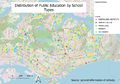
 Distribution of School Types (Public).png 3,507 × 2,480; 1.06 MB
 New Aaron 2010 Aged65+ Population.jpeg 3,507 × 2,480; 464 KB
 New Aaron 2010 Aged65+ Pop.jpeg 3,507 × 2,480; 464 KB
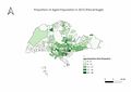
 Proportional of aged population (2010) (1).png 3,507 × 2,480; 802 KB
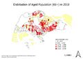
 Proportional of aged population (2018) (1).png 3,507 × 2,480; 788 KB
 1.3.jpg 1,191 × 801; 129 KB
 2010-elderly-proportion.jpg 3,507 × 2,480; 331 KB
 KO jpg Aged Population (65+) - 2018.jpg 3,507 × 2,480; 236 KB
 KO jpg Proportion of Aged Population (65+) - 2010.jpg 3,507 × 2,480; 216 KB
 2018 Proportion Aged fromaaron.jpeg 3,507 × 2,480; 461 KB
 Elderly distribution 2010.jpg 3,507 × 2,480; 496 KB
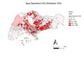
 QuestionTwoPartTwo2010.jpg 2,400 × 1,697; 292 KB
 2.1.jpg 1,111 × 772; 91 KB
 QuestionTwoPartTwo2018.jpg 2,400 × 1,697; 322 KB
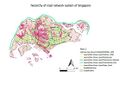
 Road Type Singapore.png 3,507 × 2,480; 1.63 MB
 Aged population (+65) in 2010 NXJ.png 3,507 × 2,480; 873 KB
 MP08 65+.png 3,507 × 2,480; 953 KB
 Landuse 2014.png 2,923 × 2,066; 1.62 MB
 Aged population (+65) in 2018 NXJ.png 3,507 × 2,480; 1,012 KB
 MP14 65+.png 3,507 × 2,480; 1.12 MB
- Error creating thumbnail: File with dimensions greater than 12.5 MP2014LandUse Map.png 4,960 × 3,507; 565 KB
 Aged population (+65) in 2018 Nxj.png 3,507 × 2,480; 1,012 KB
 Q2part3.jpg 2,400 × 1,697; 328 KB
 Aged65+Map.png 3,507 × 2,480; 864 KB
 ChristalAged65+Map.png 3,507 × 2,480; 864 KB
 Part 2 Aged Population (+65) in 2018 (1).png 3,507 × 2,480; 875 KB
 Distribution of Public Education Institutes by School Types.png 1,147 × 814; 234 KB
 Part 2 Aged Population (+65) in 2010 (1).png 3,507 × 2,480; 1.15 MB
 Christal2018Aged65+Map.png 3,507 × 2,480; 870 KB
 Aged population (+65) in 2010.png 3,507 × 2,480; 873 KB
 Geolu.jpg 1,631 × 874; 173 KB
 Aged population (+65) in 2010 .png 3,507 × 2,480; 882 KB
 2010 Aged Population 65+.jpg 875 × 632; 53 KB
 Aged population (+65) in 2010 lhy.png 3,507 × 2,480; 1,023 KB
 +65 aged 10.png 1,000 × 707; 60 KB
 2010 Population.png 1,169 × 826; 211 KB
 SchoolsbyType-min.jpg 3,838 × 2,658; 1.46 MB
 2018 population.png 1,169 × 826; 238 KB
 Landuse.png 1,169 × 826; 305 KB


_In_2010.png)
_in_2010_(1).png)
_in_2018_(1).png)


.png)


_(1).png)
_(1).png)


_-_2018.jpg)
_-_2010.jpg)


_in_2010_NXJ.png)


_in_2018_NXJ.png)

_in_2018_Nxj.png)


_in_2018_(1).png)

_in_2010_(1).png)

_in_2010.png)

_in_2010_.png)

_in_2010_lhy.png)


