G1-Group15
Organizations today are collecting data at every level of their business and in volumes that in the past were unimaginable, and 80% of all data collected has a spatial component. Therefore, the ability to generate insights using geospatial information system in the business world become utmost important. In this project, we are required to utilize the sales and geospatial data provided by our client to generate insights and provide recommendations to improve the performance of its stores in different trade areas.
Our client is a global brand in the Food and Beverage industry. It provides both dine-in and food delivery service to its customers. As the number of its stores grows bigger, it urgently needs a way to analyse the performance of its stores in different trade areas. The company provided us with data such as the boundaries and sales of their trade area, and the location of different commercial facilities to conduct our geospatial analysis. Therefore, our team aims to perform in-depth analyses of their geospatial data and uncover the relationship between its stores' location and sales.
Our team aims to perform in-depth analyses of their geospatial data and uncover the relationship between its stores' location and sales.
|
Meme Lovers aims to achieve the following project objectives:
|
| Data File | Description | Data Format | Purpose |
|---|---|---|---|
| GeoPackage | |||
| Taiwan_stores | Contains geo-coded stores | .gpkg | Allocation of Stores |
| Administrative Boundaries | |||
| County MOI | Contains county area | .shp | Show boundary |
| Town MOI | Contains town area | .shp | Show boundary |
| Street | Contains vector of street and roads | .shp | Show street and road |
| Location Maps | |||
| AE-20190313寬100高等比(鋁)含框參觀版 | Trade area of store | .pptx | Reference Layer for Digitising |
| PF-20171122寬62高103(鋁) | Trade area of store | .pptx | Reference Layer for Digitizing |
| TU-20171128寬83高53(鋁) | Trade area of store | .pptx | Reference Layer for Digitizing |
| UM-20171212寬80高67.2(木)含框 | Trade area of store | .pptx | Reference Layer for Digitizing |
| AK-20190402寬90高等比(鋁)實際版 | Trade area of store | .pptx | Reference Layer for Digitizing |
| GH-20171121寬90高70(鋁) | Trade area of store | .pptx | Reference Layer for Digitizing |
| HT-20150407寬90高115(木) | Trade area of store | .pptx | Reference Layer for Digitizing |
| MQ-20171120寬70高70(鋁)含框 | Trade area of store | .pptx | Reference Layer for Digitizing |
| SH-20171128寬84高76(鋁)含框 | Trade area of store | .pptx | Reference Layer for Digitizing |
| TC-20171129寬121高92(木)含框 | Trade area of store | .pptx | Reference Layer for Digitizing |
| TR-20171128寬70高70(鋁) | Trade area of store | .pptx | Reference Layer for Digitizing |
| XS-20171129寬63高93(木) | Trade area of store | .pptx | Reference Layer for Digitizing |
| YG-20171128寬92高92(鋁) | Trade area of store | .pptx | Reference Layer for Digitizing |
| Points of Interest | |||
| Business | Contains locations of businesses | .shp | Type of facility that will be used for analysis |
| CommSvc | Contains locations of community service facilities | .shp | Type of facility that will be used for analysis |
| EduInsts | Contains locations of education institutions | .shp | Type of facility that will be used for analysis |
| Entertn | Contains locations of entertainment facilities | .shp | Type of facility that will be used for analysis |
| FinInsts | Contains locations of financial institutions | .shp | Type of facility that will be used for analysis |
| Hospital | Contains locations of medical facilities | .shp | Type of facility that will be used for analysis |
| MiscCategories | Contains locations of miscellaneous amenities | .shp | Type of facility that will be used for analysis |
| ParkRec | Contains locations of parks and recreational areas | .shp | Type of facility that will be used for analysis |
| Restrnts | Contains locations of restaurants | .shp | Type of facility that will be used for analysis |
| Shopping | Contains locations of shopping malls | .shp | Type of facility that will be used for analysis |
| TransHub | Contains locations of transport hubs | .shp | Type of facility that will be used for analysis |
| TravDest | Contains locations of travel destinations | .shp | Type of facility that will be used for analysis |
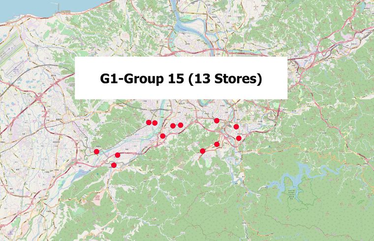
Our team has been allocated 13 Stores in New Taipei City (shown in the map below)
The table below shows the relevant facility types extracted from POI files
| Relevant Facility Type from POIs | |||
|---|---|---|---|
| ATM, 3578 | GOVERNMENT OFFICE, 9525 | ||
| BANK, 6000 | GROCERY STORE, 5400 | ||
| BAR OR PUB, 9532 | HIGHER EDUCATION, 8200 | ||
| BOOKSTORE, 9995 | HOSPITAL, 8060 | ||
| BOWLING CENTRE, 7933 | HOTEL, 7011 | ||
| BUS STATION, 4170 | MEDICAL SERVICE, 9583 | ||
| BUSINESS FACILITY, 5000 | PHARMACY, 9565 | ||
| CINEMA, 7832 | RESIDENTIAL AREA/BUILDING, 9590 | ||
| CLOTHING STORE, 9537 | RESTAURANT, 5800 | ||
| COFFEE SHOP, 9996 | SCHOOL, 8211 | ||
| COMMUTER RAIL STATION, 4100 | SHOPPING, 6512 | ||
| CONSUMER ELECTRONICS STORE, 9987 | SPORTS CENTRE, 7997 | ||
| CONVENIENCE STORE, 9535 | SPORTS COMPLEX, 7940 | ||
| DEPARTMENT STORE, 9545 | TRAIN STATION, 4013 | ||


