G1-Group05 Proposal
Contents
Proposal
About Taipei and Yilan
Taipei, the capital of Taiwan, is the most populated city in Taiwan with around 7 million people in the city and surrounding areas. In contrast, Yilan is a county in northeastern Taiwan. Even though its land area is 8 times the size of Taipei, it has a low population of around 450,000 people. Joining together both counties is Jiang Yushui Expressway (National Freeway 5).
Project Motivation
Our client is part of the International Food and Beverage franchise that is currently present in Taiwan. Our client has provided us with data to analyse each outlet and their respective trade areas have impacted the franchise's business in Taipei and Yilan. By understanding the trade areas of each location better, we can identify what influences the performance of each outlet.
Our project aims to digitise and delineate the trade areas, as well as study the points of interest per area. We can then provide useful information for our client by analysing effect the different points of interests have on sales. This information will allow for more informed business decision-making, especially when assessing the success of their current outlets considering the viability of a potential new outlet location.
Project Objectives
Highway to Taipei aims to achieve the following objectives by the end of the project:
- Digitise and delineate Operational Trade Areas
- Analyse the overlapping trade areas of the outlets
- Extract significant POIs
- Analyse impact of POIs in each trade area of each outlet
- Perform drive time analysis & impact on trade areas
- Create GIS maps for data visualisation
- Summarise findings in a poster & report
About Areas Studied
Our group studied 14 franchise outlets, 9 of which were located in Taipei and 5 in the Yilan region of Taiwan. The areas we received were mostly clustered together. This allows us to take away certain assumptions, and instead focus on seeing how the points-of-interest and trade area properties impact annual sales.
Scope of Work
Our main tool to perform our analyses was QGIS, a free and open-source geographic information system. To support our findings with more in-depth calculations, we used SAS Enterprise Guide.
Data Preparation
- Digitisation of trade areas onto QGIS
- Trade Area Buffer Creation
- Voronoi Polygon Creation
- POI Counting
- Data Cleaning
Performing GIS Analysis
- Vector-Based Analysis
- Raster-Based Analysis
- Trade Area Analysis
- Multiple Linear Regression
- POI-Sales Analysis
- Drive Time Analysis
Project Deliverables
- Poster for Townhall Presentation
- Full Report
- Wiki Report
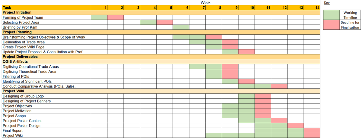
Project Timeline
Project Reference
Data Sources
| Data Name | Data Format | Source | |
|---|---|---|---|
| Landuse (2008/2014/2019) | |||
| URA Planning Areas (2008) | Shape files | https://data.gov.sg/dataset/master-plan-2008-planning-area-boundary-no-sea | |
| URA Planning Areas (2014) | Shape files | https://data.gov.sg/dataset/master-plan-2014-planning-area-boundary-web | |
| URA Planning Areas (2019) | Reference | https://www.ura.gov.sg/Corporate/Planning/Draft-Master-Plan-19 | |
| Population | |||
| Population (2015) | CSV | https://www.singstat.gov.sg/find-data/search-by-theme/population/geographic-distribution/latest-data | |
| Population (2019) | CSV | https://www.singstat.gov.sg/-/media/files/publications/population/population2019.pdf | |
| Profession | CSV | https://www.tablebuilder.singstat.gov.sg/publicfacing/createSpecialTable.action?refId=8321 | |
| Education & Healthcare Services | |||
| Childcare Services | Shapefile | https://data.gov.sg/dataset/listing-of-centres | |
