G1-Group05 Proposal
Contents
Proposal
About Taipei and Yilan
Taipei, the capital of Taiwan, is the most populated city in Taiwan with around 7 million people in the city and surrounding areas. In contrast, Yilan is a county in northeastern Taiwan. Even though its land area is 8 times the size of Taipei, it has a low population of around 450,000 people. Joining together both counties is Jiang Yushui Expressway (National Freeway 5).
Project Motivation
Our client is part of the International Food and Beverage franchise that is currently present in Taiwan. Our client has provided us with data to analyse each outlet and their respective trade areas have impacted the franchise's business in Taipei and Yilan. By understanding the trade areas of each location better, we can identify what influences the performance of each outlet.
Our project aims to digitise and delineate the trade areas, as well as study the points of interest per area. We can then provide useful information for our client by analysing effect the different points of interests have on sales. This information will allow for more informed business decision-making, especially when assessing the success of their current outlets considering the viability of a potential new outlet location.
Project Objectives
Highway to Taipei aims to achieve the following objectives by the end of the project:
1. Digitise and delineate Operational Trade Areas
2. Analyse the overlapping trade areas of the outlets
3. Extract significant POIs
4. Create business / customer profiles
5. Analyse impact of POIs in each trade area of each outlet
6. Create GIS maps for data visualisation
7. Summarise findings in a poster & report
About Areas Studied
Digitisation
Stores alr have their own trade area based on delivery services (operational trade area) --> Manually digitise outer boundary, then inner boundary
Trade Area Analysis
- Buffer trade area --> Mutually exclusive (like today's lesson)
- Varied distance trade area
Comparative Analysis
Compare btw theoretical & operational trade area
- Points of interests (POI) within each TA (eg. Biz establishments) -- Use facility type codes in code book "Map Releases - Taiwan PDF"
Point in polygon count for each POI of interest --> Run as Batch Process
- Sales figures
- Drive time
Scope of Work
Data Preparation
- Digitisation of trade areas
- Ideal trade area
- Operational trade area
Performing GIS Analysis
- Comparison between ideal & operational trade area
* POI within each TA
* Sales figures
* Drive time
Project Deliverables
- Preparing report of survey
- Preparing poster and materials for townhall presentation
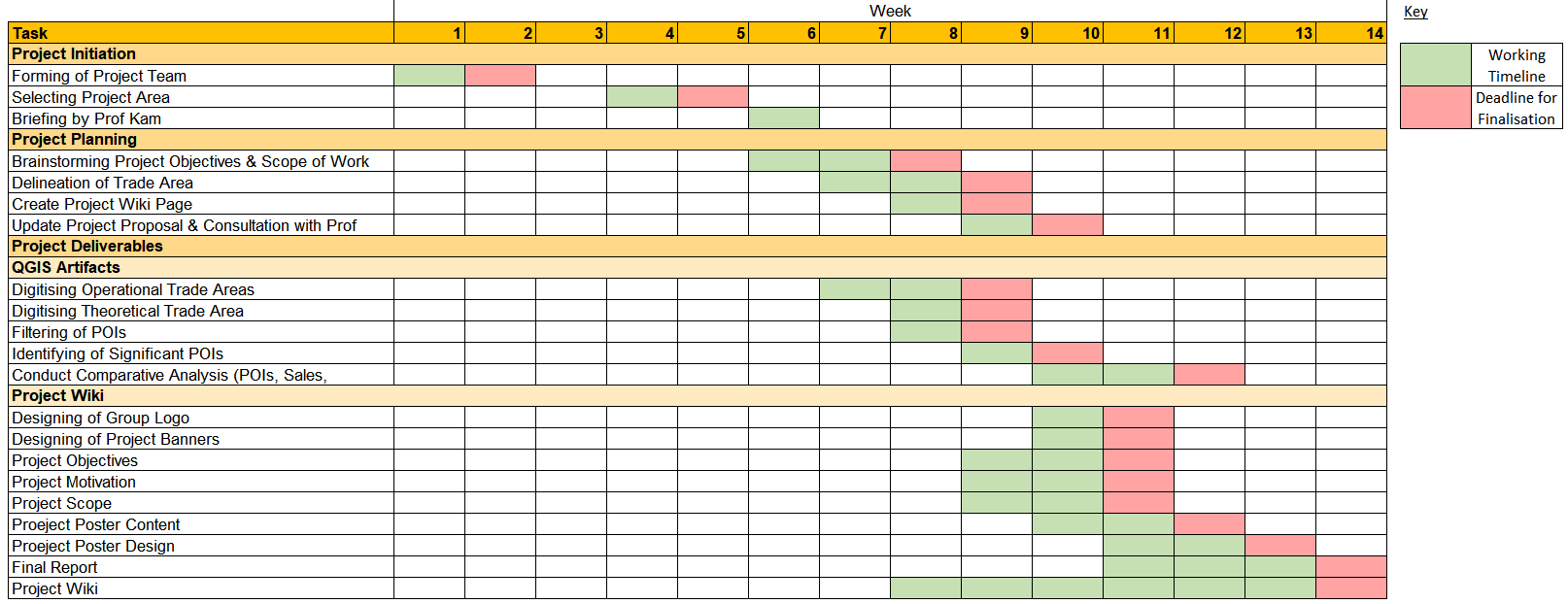
Project Timeline
Project Reference
Data Sources
| Data Name | Data Format | Source | |
|---|---|---|---|
| Landuse (2008/2014/2019) | |||
| URA Planning Areas (2008) | Shape files | https://data.gov.sg/dataset/master-plan-2008-planning-area-boundary-no-sea | |
| URA Planning Areas (2014) | Shape files | https://data.gov.sg/dataset/master-plan-2014-planning-area-boundary-web | |
| URA Planning Areas (2019) | Reference | https://www.ura.gov.sg/Corporate/Planning/Draft-Master-Plan-19 | |
| Population | |||
| Population (2015) | CSV | https://www.singstat.gov.sg/find-data/search-by-theme/population/geographic-distribution/latest-data | |
| Population (2019) | CSV | https://www.singstat.gov.sg/-/media/files/publications/population/population2019.pdf | |
| Profession | CSV | https://www.tablebuilder.singstat.gov.sg/publicfacing/createSpecialTable.action?refId=8321 | |
| Education & Healthcare Services | |||
| Childcare Services | Shapefile | https://data.gov.sg/dataset/listing-of-centres | |
