Difference between revisions of "SMT201 AY2019-20T1 EX1 Eddie Leow Kian Giap"
| Line 7: | Line 7: | ||
[[File:14MPLandUse MapImage.png|thumb|center]] | [[File:14MPLandUse MapImage.png|thumb|center]] | ||
<br> | <br> | ||
| + | For each of the thematic map above, explain why your cartographic technique makes sense, your choice of classification and visual variable. Please limit your discussion to a maximum of not more than 100 words per map. | ||
| + | |||
=== Part 2: Choropleth Mapping<br> === | === Part 2: Choropleth Mapping<br> === | ||
Using planning subzone GIS data from data.gov.sg and Singapore residents by age group and gender, prepare the following choropleth maps:<br> | Using planning subzone GIS data from data.gov.sg and Singapore residents by age group and gender, prepare the following choropleth maps:<br> | ||
Revision as of 01:07, 15 September 2019
Part 1: Thematic Mapping
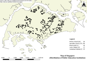
Using school information from data.gov.sg, prepare a thematic map showing the distribution of public education institution by school types such as primary, secondary, etc.
Using road GIS data of LTA, prepare a thematic map showing the hierarchy of road network system of Singapore such as expressway, major road, minor road, etc.
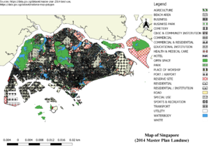
Using master plan landuse GIS data from data.gov.sg, prepare a thematic map showing 2014 Master Plan Landuse.
For each of the thematic map above, explain why your cartographic technique makes sense, your choice of classification and visual variable. Please limit your discussion to a maximum of not more than 100 words per map.
Part 2: Choropleth Mapping
Using planning subzone GIS data from data.gov.sg and Singapore residents by age group and gender, prepare the following choropleth maps:
- Aged population (+65) in 2010 and 2018.
- Proportional of aged population in 2010 and 2018.
- Percentage change of aged population between 2010 and 2018.
In separate text describe the spatial patterns, if any, reveals by each of the choropleth maps prepared.
Explain the reasoning behind your classification choices, how you derived the new variables and handled missing values, and any other relevant judgments and assumptions. Please limit this discussion to a maximum of not more than 500 words.
In order to derive the missing values of the aged population (65 years old and above) in 2018, I calculated the percentage of each subzone based on the data set found in 2017 on data.gov. With the percentage, I multiplty it with another data set which compromises of aged population in 2018 found on data.gov to derive the value for each subzone in 2018. The missing values found in the data set are ignored because it does not affect the outcome of the mapping.


