Difference between revisions of "SMT201 AY2019-20T1 EX2 Lim Jia Khee"
Jump to navigation
Jump to search
| Line 19: | Line 19: | ||
</br> | </br> | ||
[[File:Map Layout 2.png|1000px|thumb|center]] | [[File:Map Layout 2.png|1000px|thumb|center]] | ||
| + | </br> | ||
| + | {| class="wikitable" | ||
| + | |- | ||
| + | ! Data !! Source !! Data Description !! Source URL !! Data Type | ||
| + | |- | ||
| + | | <center>Seattle Open Airbnb Data</center> || <center>Inside Airbnb</center> || <center>Information on all Airbnb listings found within Downtown Seattle, last scrapped on 15 November 2018</center> || <center>http://insideairbnb.com/get-the-data.html</center> || <center>CSV File</center> | ||
| + | |- | ||
| + | | <center>Common Place Name (CPN)</center> || <center>City of Seattle Open Data Portal</center> || <center>A point feature class showing common place names and corresponding locations in Seattle.</center> || <center>https://data.seattle.gov/Land-Base/Common-Place-Names-CPN-/599c-9ddc</center> || <center>CSV File</center> | ||
| + | |- | ||
| + | | <center>City Clerk Neighbourhoods</center> || <center>Seattle.gov</center> || <center>Displays the 20 Large City Clerk neighborhood boundaries, along with their smaller neighborhood boundaries.</center> || <center>https://data.seattle.gov/dataset/City-Clerk-Neighborhoods/926y-cwh9</center> || <center>SHP File</center> | ||
| + | |- | ||
| + | | <center>Zoning (Generalized)</center> || <center>Seattle GIS Open Data</center> || <center>A polygon feature class showing zoning areas. It also provides information on the type of zoning such as Downtown, Major Institutions, Manufacturing/Industrial, Multifamily, Neighbourhood/Commercial, Residential/Commercial and Single Family.</center> || <center>https://data-seattlecitygis.opendata.arcgis.com/datasets/a85e74dac41d43cab5a8b840558c4d77_3?page=15</center> || <center>SHP File</center> | ||
| + | |} | ||
== Part 3: Standardisation of Proximity Analysis == | == Part 3: Standardisation of Proximity Analysis == | ||
Revision as of 23:13, 9 November 2019
Contents
Part 1: Initial Data Visualisation/Exploration of Vector Layers

| Data | Source | Data Description | Source URL | Data Type |
|---|---|---|---|---|
Part 2: Proximity Analysis

| Data | Source | Data Description | Source URL | Data Type |
|---|---|---|---|---|
Part 3: Standardisation of Proximity Analysis

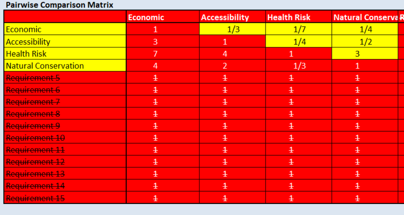
Part 4: Analytical Hierarchical Process (AHP) input matrix and result report
 |
 |
| Data | Source | Data Description | Source URL | Data Type |
|---|---|---|---|---|
Part 5: Suitable landlot(s) identified
