Difference between revisions of "Course information"
(Created page with "<div style=background:#2B3856 border:#A3BFB1> 200px <font size = 5; color="#FFFFFF">SMT201 Geospatial Analytics for Urban Planning</font> </div> <!--MA...") |
|||
| Line 1: | Line 1: | ||
<div style=background:#2B3856 border:#A3BFB1> | <div style=background:#2B3856 border:#A3BFB1> | ||
[[Image:UrbanGIS.jpg|200px]] | [[Image:UrbanGIS.jpg|200px]] | ||
| − | <font size = 5; color="#FFFFFF">SMT201 | + | <font size = 5; color="#FFFFFF">SMT201 Geographic Information Systems for Urban Planning</font> |
</div> | </div> | ||
<!--MAIN HEADER --> | <!--MAIN HEADER --> | ||
Latest revision as of 09:03, 14 August 2019
|
|
|
|
|
|
Contents
Synopsis
Effective planning and management of smart cities require urban planners to integrate and share data from multiple sources to the urban users so that they can be active participants in the smart city planning process. GIS with its capability to capture, manage, display, and analyse information spatially is emerging as one of the important enabling tool in smart city planning.
This course provides students with an introduction to practical applications of GIS in smart city management and planning. Emphasis will be placed on (i) locating, acquiring and integrating multi-sources of data into GIS, (ii) understand the principles and methodologies of geocoding and geo referencing , (iii) become familiar with geovisualisation and GIS analysis techniques, and (iv) explore the technologies and possibilities of GIS-enabled Planning Support Systems for smart city management.
Objectives
Upon completion of the course, students will be able to:
- Understand the basic concepts and theories of GIScience and trends of GIS technologies.
- Create, integrate, manage geospatial data and build enterprise level geospatial database management systems.
- Use appropriate GIS analysis functions to visualise and analyse urban sector data.
- Model smart city processes using GIS’ advanced analytical methods.
- Design and implement cutting-edge GIS-based Planning Support Systems for smart city management.
Course structure
Basic Modules
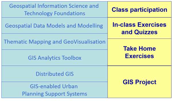
This course comprises ten integrated components as shown below:
Course description
- Concepts and Theories of GIS in Smart City Planning and Management
- GISystems, GITechnologies, and GIScience
- Computerised mapping and GIS
- A gallery of GIS applications in smart cities planning and management
- Geospatial Data Repositories: Design, Implementation and Management
- Representing geography: spatial data models
- Modelling our world: spatial data modelling
- Bringing data into GIS: projection, georeferencing, and geocoding .
- Data quality, management and distribution issues.
- A Picture is Worth a Thousand Words: Visualising Geographic Information
- Thematic mapping and cartography
- Geovisualisation and spatial query
- Map analysis
- GIS Analytics Toolbox
- Basic GIS analysis and functions: measurements and spatial query
- Vector-based geoprocessing and analysis: spatial join, map overlay, and buffering.
- Raster-based GIS analysis
- Terrain analysis
- Network analysis and GIS
- Bringing It All Together: GIS-enabled Urban Planning Support System
- Cartographic modelling
- Analytical modelling and decision support
- Distributed GIS
- Web-based GIS
Grading Summary
The grading distribution of this course are as follows:
- Class Participation 5%
- In-class Exercises and Quizzes 15%
- Take Home Exercises 30%
- GIS Project 50%
There will be no mid-term test or final examination for this course.

